Summer-like pattern is setting up for drought conditions.

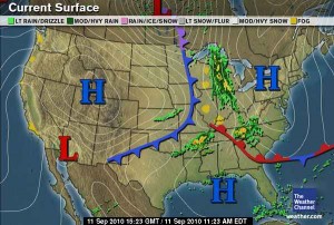
The passage of the cold front early this morning has left the area with much cooler and drier air in place, but the heat shall return for the weekend and well into next week.  The main reason for this is due to the overall lack of soil moisture.  This lack of soil moisture is leaving the boundary layer much drier, and the jet stream pattern has gone to a more summer-like pattern as opposed to something that would be expected in mid-September, with the main core of jet energy well to the north over southern Canada, leaving much of the United States high and dry.  Lack of moisture is going to allow for wide temperature fluctuations between day and night, and indications show that next week daily maximum temperatures could reach into the mid 90s—rather unseasonable warmth for this time of year.  This pattern is somewhat reminiscent of what was seen during the summer and early fall of 2007.  All indications are that the next week will be dry and hot, only exacerbating the drought conditions.

Posted in Kentucky Weather | Comments Off on Summer-like pattern is setting up for drought conditions.

Severe potential diminishing, but not gone.

The 17Z GOES Skew-T sounding shows much greater CAPE than earlier, just shy of 4000, as well as a lifted index of -7.  The SWEAT index was also close to 300 as well in this sounding.  At the same time, the latest (18Z) SPC Mesoanalysis does not concur with that very well at all, showing CAPE of 1000 in the area.  Much of the dynamics needed to fuel severe thunderstorms are concentrated farther north in Illinois, Indiana and Ohio, and storms are already firing up in central and northern Indiana and into northern Ohio.  All of that being said, severe storms cannot be ruled out here in the area, but conditions just are not that conducive here for widespread severe weather.  Severe weather, if any, will likely be very isolated.

Posted in Kentucky Weather | Comments Off on Severe potential diminishing, but not gone.

Storms today? Weekend weather.

A low centered about over Lake Michigan is bringing Bowling Green area much of the Mid-South some rain and thundershowers this morning.  Indications from the SPC, yesterday, showed a Slight Risk for severe weather, but in accordance with some of the latest model runs, that threat has been shifted more toward the east, with Bowling Green and places to the west and immediately to the east of I-65 not really expecting to see the greatest amount of convection, as these areas are on the far western extent of the risk area.

Continue reading

Posted in Kentucky Weather | Comments Off on Storms today? Weekend weather.

Another nice day today, Thursday storm chances?

Today will be much the same story as yesterday, with the exception of slightly warmer temperatures as winds have shifted out of the south. Bowling Green should reach 90 today with a low tonight of around 65 with increasing clouds.

The main story however is tomorrow’s weather. Currently a potent mid level shortwave, and its resulting surface low and cold front, are ejecting out of the Rockies and is forecast to be in the Great Lakes region by tomorrow. This coupled with upper level jet dynamics will make for a descent synoptic setup for thunderstorm development over Eastern Kentucky. However, both the NAM and GFS forecast models have sped up the surface cold-front, and show this cold-front passing much earlier than was forecast yesterday. It is presently forecast to be Through south-central Ky by mid-day, before maximum heating and instability can be realized. Model soundings indicate only marginal CAPE at less than 1000 J/Kg for our region as surface instability will be a limiting factor for severe weather.

So, in a nutshell, tomorrow’s slight severe threat seems to be decreasing for Bowling Green, but only time will tell. Clouds will be on the increase tonight as this system approaches, which will keep nighttime temps higher than yesterday. There is a good chance for rain tomorrow morning through mid-day as the cold front approaches, with some embedded thunderstorms. If you live in eastern Ky the threat of severe weather increases as maximum daytime instability is realized before passage of this cold front. Regardless, hope for some rain…we could use it.

Posted in Kentucky Weather | Comments Off on Another nice day today, Thursday storm chances?

Another nice day..storms for thurday?


Today’s weather will be similar to yesterday with the exception of a few 500mb shortwaves traveling through the flow. Visible satellite imagery shows this in the form of mid to high level clouds moving into our area this afternoon. The high today will be 86 and a low tonight of 59.

Thursday, both the NAM and GFS are in good agreement of a surface low ejecting out of the southern plains. We will be in the warm sector of this surface low and moisture should be on the increase by Wed night, with resulting cold front moving through Bowling green on Thursday increasing the chance for showers or thundershowers. With increased instability and frontal timing approaching maximum heating, the SPC has put our area under a slight risk for severe thunderstorms on Thursday.

day3otlk_0730

On a side note, hurricane Igor is still a major category 4 hurricane and is expected to have minimal impact on the contiguous United States. This information on Igor and other tropical systems can be found at the National Hurricane Centers website at http://www.nhc.noaa.gov/ .

Posted in Kentucky Weather | Comments Off on Another nice day..storms for thurday?

Cool nights… warm days ahead.

Today’s weather is dominated by a northwest flow aloft, with a jet parked over the mid-west. This upper level feature will keep any cool air bottled up over the great lakes. At the surface, a high pressure maximum exists along the TN border which should keep our weather rather tame, with the next chance of precipitation being Thursday. With subsiding dry air associated with this high pressure in place, expect comfortable conditions with highs through Wednesday in the mid to upper 80’s and the lows at night trying to reach the 60 degree mark. Today expect sunny skies with a WSW wind of 5-10mph with a high temp in Bowling Green of 88, and a low of 59 tonight as radiational cooling takes place under clear skies. More on Thursdays precipitation chances to come…

Posted in Kentucky Weather | Comments Off on Cool nights… warm days ahead.

A possible stormy afternoon

Mother nature looks to be giving us a break today as the severe threat this afternoon has minimized. A warm front will pass through the area late morning, allowing some warm moist air to advect ahead of the advancing cold front that could allow for some re-development of some strong storms later in the afternoon. But models are agreeing in some weakening of the low level winds which will lessen the convergence ahead of the cold front.  Re-development is still possible but not as likely as previously predicted. So still keep an eye on the sky, I will update and inform you of any changes through out the day.

Otherwise, enjoy the sunshine the first part of the day as clouds will move back into the area in the afternoon.  Will likely see some showers throughout the day, with a possible stray thunderstorm.  High 87. Low 63.

Tonight:  Cold front should pass through around dinner time and all chances of rain should diminish by 8 p.m.

Sunday:  Mostly sunny, with a nice northerly wind to help keep the high at 81. North winds 5-10 knots.

Current Weather Map

Posted in Kentucky Weather | Comments Off on A possible stormy afternoon

Rain looks to continue

Persistent rain looks to stick around for much of the day today, with little chance of strong storms.  However right now Saturday afternoon looks like instability is in place for some severe activity to initiate.  An update will be available Saturday morning as the instability of the atmosphere becomes more apparent.

Today- Expect rain to stick around with a high temperature of 76. Low 65. Winds from the southeast 5-10 knots.

Saturday- Rain staying persistent through the overnight hours and into the morning, as the day goes on severe weather could threaten the area. A bit warmer and humid with a high of 87. Low 65. Winds weakening heading into the evening.

Be sure to stay tuned for the update on tomorrow’s severe potential. Here is an SPC forecast for Saturday (see the link below).

http://www.spc.noaa.gov/products/outlook/day2probotlk_0600_any.gif

Posted in Kentucky Weather | Comments Off on Rain looks to continue

Remnants of Hermine may bring some rain this way…

The remnants of tropical storm Hermine is located over the western portion of Arkansas and is bringing showers and storms into that area at the moment.  As the low pressure slowly progresses its way eastward, we start to increase our chances of some stray showers and storms.  There is a stationary boundary south of the area that will push its way E/NE over the area in the next 24 to 48 hours.  The boundary will bring with it increasing chances of rain, but little in the way of cooler temperatures as it passes.

Today we can expect mostly cloudy skies, clouds increasing more throughout the day.  30% chance of showers late tonight and early morning. High 79. Low 63. Light winds out of the East.

Look for a weekend update sometime tomorrow.

Posted in Kentucky Weather | Comments Off on Remnants of Hermine may bring some rain this way…

Status report on La-Nina

Right now la-nina conditions are present in the pacific ocean. Modeling suggests that the la-nina will become moderate to strong by the start of winter before returning back to moderate by the end of  winter. For us this likely means a return to wetter than normal conditions by the end of the year. This is good news for the western part of the state still currently in drought.  Here are some links to the latest la-nina report and to our new wrf model here at western.

Posted in Kentucky Weather | Comments Off on Status report on La-Nina