Lovin’ Winter

Familiar sight this morning, isn’t it? Clipper system pushed through with the front last night, this will continue to effect the area throughout the day as a dry slot will shift from west to east. This is expected to drop even more snow across the area, with more blowing and drifting expected. Skies have opened for a brief period, only to allow strong winds and clouds to roll back in later today. Surface low that is currently over Louisville will shift east, while the upper-level low over southeast Missouri will push E/NE across the area today. Continue reading

Posted in Kentucky Weather | Comments Off on Lovin’ Winter

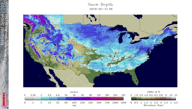
Snow in all lower 48 states

This map of snow cover from this morning shows snow cover in all lower 48 states. This is a very rare event that has not happened in recent memory. Scientists at the Rutgers Global Snow Lab are investigating when the last time this may have happened.

snow-in-49-states1

Posted in Kentucky Weather | Comments Off on Snow in all lower 48 states

More snow on Sunday

It appears we will see yet another decent snowstorm on Sunday and into Monday over the Mid-South, as expected. Continue reading

Posted in Kentucky Weather | Comments Off on More snow on Sunday

Manitoba Mauler on track for Sunday/Monday

The latest model runs of the GFS, CMC, and ECMWF all show a Manitoba Mauler (the mean, nasty cousin of the Alberta Clipper) poised to bring more snow to the Mid-South late this weekend. Both the CMC and ECMWF are further south with the track of the vort max (over TN) compared to the GFS (over KY) which will strongly influence snow amounts. Continue reading

Posted in Kentucky Weather | Comments Off on Manitoba Mauler on track for Sunday/Monday

A break in the action, for now

It’s been an interesting couple of days as far as winter weather goes here in south central Kentucky, but it appears we’ll be getting a break from the snow for a few days. Continue reading

Posted in Kentucky Weather | Comments Off on A break in the action, for now

Snowiest winter in Bowling Green since 1985

The storm that brought several inches of snow to KY on February 8-9 ended up bringing a total of 5.1″ of snow to Bowling Green. Here is the breakdown of the storm…

Monday, February 8th, 7:30 pm – 12:00 am: 2″ of snow

Tuesday, February 9th, 12:00 am – 7:00 am: 0.40″ of rain

Tuesday, February 9th, 7:00 am – 12:00 pm: 0.9″ of snow

Tuesday, February 9th, 4:00 pm – 10:00 pm: 2.2″ of snow (3.1″ of snow for the day sets a new record for the date)

Storm total: 5.1″ of snow and 0.40″ of rain.

Season total: 13.5″ of snow which ties for 30th all-time for Bowling Green and is the most snow since 1985 (17.6″).

The longrange models and the weather pattern suggest several more snow chances through the end of the month.

Posted in Kentucky Weather | Comments Off on Snowiest winter in Bowling Green since 1985

Bowling Green will see snow tonight, but how much?

Recent model runs are predicting better snowfall totals than previously expected for south central Kentucky with tonight’s impending winter storm. Continue reading

Posted in Kentucky Weather | 1 Comment

Early-week storm heating up…literally

The belief over the past week is that the major storm that will move through the Mid-South early next week would be a significant snow-maker for everyone in Kentucky.  But recent model outputs express a mixed-bag of precipitation for south central Kentucky with warmer temperatures in place than previously thought. Continue reading

Posted in Kentucky Weather | Comments Off on Early-week storm heating up…literally

dry slot takes away second band and higher end totals

Storm totals were from 5-7 inches across our region. This was slightly less than my going forecast of about 8 inches with the potential for locally more perhaps even over a foot. This was due to a dry slot which formed along the Kentucky/Tenn line late in the overnight  as a result another period of snow across western Kentucky which was producing moderate snowfall tracked just north of our region this would have produced another 2-4 inches of snow ( locally more) and the forecast would have verified.  As for the historical aspect of the storm we’ll see if the official measurement is 6 inches right now I would doubt it only getting 5.5 where i am.

looking ahead the rest of the weekend will be cold with highs only in the 20’s and single digits for lows. There will be a chance of light snow on Tuesday with another system late next week.  enjoy the snow.

MG

Posted in Kentucky Weather | 2 Comments

updated forecast

snow ratios- using the avg mesonet qpf of .15 and snowfall reports of 2-3 inches earlier and looking at the composition of the snow a 15:1 ratio seems reasonable with temps in the 20’s.

banding- snow had become banded in nature with dry slots heading heading our way getting filled back in again moderate snow should continue through 1 am with rates of .5 to 1 inch per hour. It is very possible as the low moves east the bands stay right over the bowling green area and then as the low moves northeast pinwheel back around again along the snow from the second part making it a steadier area tomorrow morning. Right now no major dry slot is expected.

modeling- the gfs had to many deep thunderstorms in the first 6 hrs ,while the nam’s frist 6 hrs were a fairly accurate view of things. I will use a blend of the nam and ruc models for this forecast. The ruc is the rapid update which updates every hour and is ncep’s model page.

forecast- thse models call for an addtional .5  qpf give or take a little overnight and Saturday morning which could be another 7.5  inches of fresh snow. so with that being said will raise totals to 7-14 inches for the Bowling Green which would make this the biggest snow in over 20 years. One point unlike with the 6-10 where I leaned toward the higher end this forecast will lean toward the lower end of the range (7-14).

Enjoy the snow!!

MG

Posted in Kentucky Weather | 1 Comment