Remnants of Delta Passing Through

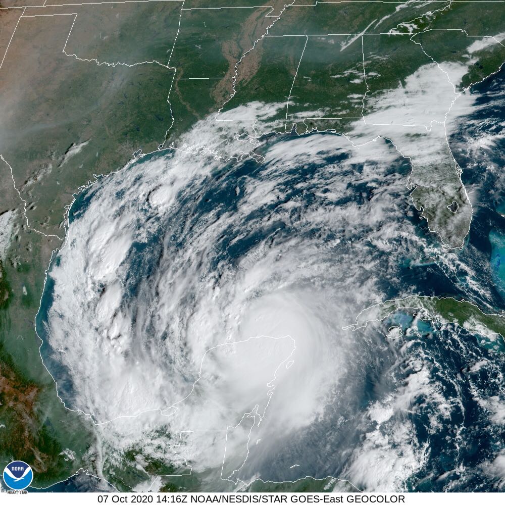
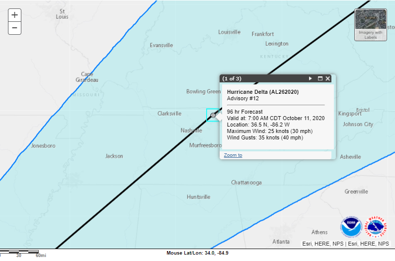
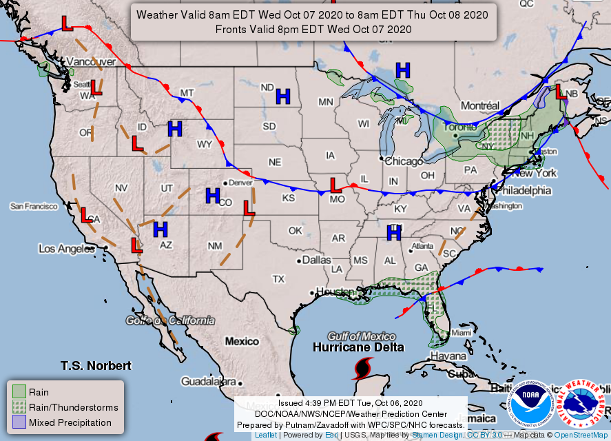
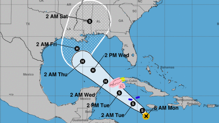
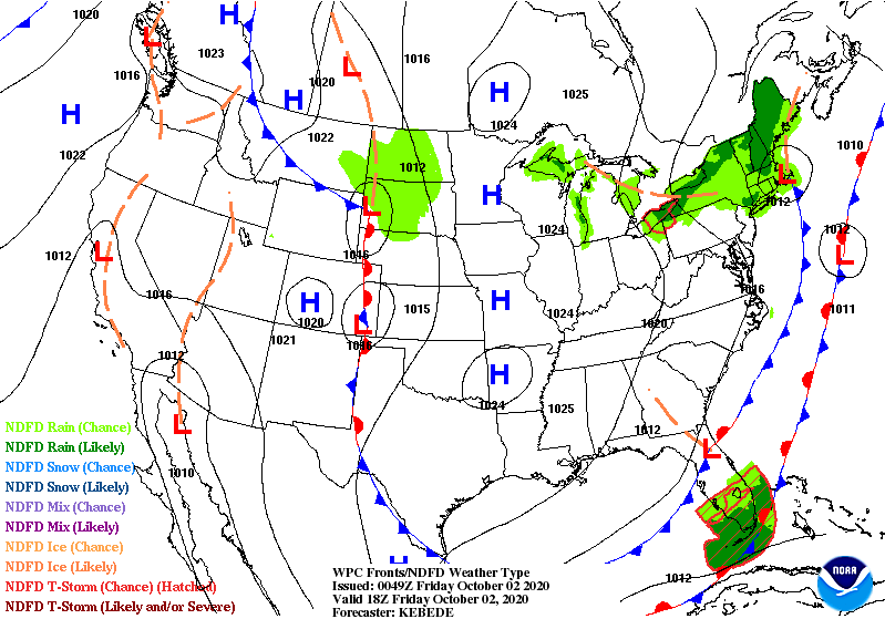
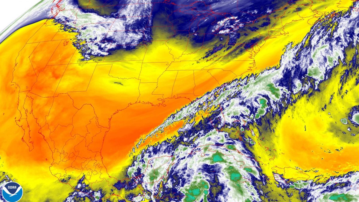
The remnants of Delta have mostly finished passing through and that’s going to come with a small chance of rain for the start of your work week. The high for today is 81F and the low is 47F with a slight chance of rain being the main concern for the day right around lunch hour to 3:30 pm as a weak frontal boundary passes through. Nothing major though as this is only expected to affect our western counties. Winds will remain out of the southwest for the day at 13mph, keeping us mild for the day. Sunshine will remain on the board for the rest of the week, but we do catch another chance of rain as we end the work week so definitely stay tuned!

Posted in Kentucky Weather | Comments Off on Remnants of Delta Passing Through

Prepare for a Soggy Weekend!

Well the week has remained fairly mild and dry for the most part but that is coming to an end as we approach the weekend. The high for today is 82F and the low is 62F. If you have any last minute outdoor work to do before the weekend, today is the day to get that out of the way. Though today is expected to remain dry, Hurricane Delta will be the primary cause of showers intervening with out Saturday into Sunday. The day is expected to remain mostly cloudy due to cloud cover coming in from Hurricane Delta. Precipitation for the weekend will be anywhere from 1-2″, though some areas of localized flooding is the main concern. Overall though, there is no concern for a severe weather threat we’ll just have to bunker down for a rainy weekend.

[Image of WPC QPF U.S. rainfall potential]

Source: https://www.nhc.noaa.gov/refresh/graphics_at1+shtml/091227.shtml?rainqpf#contents

Posted in Kentucky Weather | Comments Off on Prepare for a Soggy Weekend!

Today in Weather History

On October 8th, 2008, the southern region of the country had its fair share of severe weather. That day, a surface low pressure system was stationed over the state of Alabama with a cold front extending from the southwestern part of the state to western Florida. This frontal boundary promoted the presence of severe weather, having created eight total tornadoes over Alabama, Georgia, and Florida. Of these, according to the National Weather Service, two were EF1 and six were EF0.

Below is a photo from Panama, FL, where a tornadic waterspout moved inland and stirred up trouble.

(National Weather Service)
Posted in Kentucky Weather | Comments Off on Today in Weather History

Warm Conditions Before a Wet Weekend

Good morning! Hopefully everyone is enjoying the sun right now because this weekend will be a soggy one. Winds from the west continue to help bring in warmer temperatures as they move around the high pressure sitting to the southwest.

This afternoon that cold front will drift through but won’t have much of an impact on temperatures outside of preventing them from getting any warmer.

The next biggest impact to local weather will come from what is now Hurricane Delta. Here is the latest satellite image of the hurricane as it approaches landfall:

Source: NOAA
Source: NHC

The latest advisory from the National Hurricane Center has the system as a tropical depression that should be around the area early Sunday morning. With the rain bands, we will likely start to see impacts Friday night with the peak of the system hitting Saturday night into Sunday. Soon we should have a clearer picture of timing and those impacts. For now, enjoy the sunshine!

  • SUMMARY:
    • Wednesday:
      • High: 84
      • Low: 53
    • Thursday:
      • High: 81
      • Low: 52
    • Friday:
      • High: 80
      • Low: 58
      • Precipitation: Trace

Stay safe, stay healthy, and have a great week!

Posted in Kentucky Weather | Comments Off on Warm Conditions Before a Wet Weekend

The Calmness Continues

Welcome back to the Western Kentucky University Meteorology Blog! So far, we’ve had a rather pleasant trend thanks to the lack of disturbances in the atmosphere and we can expect for it to continue on throughout the work week. As shown below, a high pressure system will be dominating our forecast for tomorrow, bringing about a similar forecast for what we’ve seen so far this week.

Moreover, expect lots of sunshine paired with dry, breezy conditions. We will see temperatures reach the lower 80’s and drop to the lower 50’s. For now, Friday looks to be the start of storm chances for the week, but we will be monitoring this closely and updating you in the days to come.

Posted in Kentucky Weather | Comments Off on The Calmness Continues

Sun Galore for the Week!

Expect temperatures to be cooler for the start of the week with a high of 66F and a low of 38F. Some folks even woke up to some patchy frost this morning! The Tennessee Valley is currently under a high pressure system, which is expected to keep those sunny and dry conditions around for most of the week! Things will start warming up tomorrow and temperatures will stay in the high 60’s to mid 70’s for the remainder of the work week.

Tropical storm Delta is expected to make landfall on the Louisiana, Mississippi, and Atlanta coast sometime late this week. Delta is expected to strengthen into a hurricane by the time it makes landfall. Stay tuned to see how this will affect our weather story for next week!

Courtesy: https://www.npr.org/2020/10/05/920304101/tropical-storm-delta-forms-forecast-to-hit-gulf-coast-as-hurricane-late-this-wee

Posted in Kentucky Weather | Comments Off on Sun Galore for the Week!

Fall Weather is Here!

Prepare for a chilly but sunny Friday as the Tennessee Valley as a high pressure system rolls in. The high for today is 64°F and the low is 41°F. Winds out of the SW are helping in bringing that colder air in. Though things are cooling down, some regions in Kentucky will struggle to make it out of the 60’s and remain in the upper 50’s, so definitely pull that sweater out as you head on with your day! Expect the same weather story for Saturday, with a high of 67°F and a low of 46°F with mostly sunny conditions. Sunday brings in a chance for pop up scattered showers, but the models show uncertainty in some areas of KY so stay tuned! Sunday’s high will be 66°F with a low of 45°F.

Enjoy your weekend and these first tastes of Fall!

Posted in Kentucky Weather | Comments Off on Fall Weather is Here!

Pleasant Seasonal Trend

Welcome back to the Western Kentucky University Meteorology Blog! That seasonal trend will carry out through the start of the weekend, so expect fair skies, gentle breezes, and cooler temperatures. To put it simply, high pressure will be prominent in the Midwest, as shown in the graphic below. We won’t be expecting any disturbances until Sunday, where we may have a handful of showers move through the area.

(Weather Prediction Center)

Check out the photo below to see the water vapor content in the lower levels of the atmosphere. For reference, the warmer colors indicate lower amounts of moisture whereas cooler colors indicate the opposite. Right now, almost all of the country has little to no moisture to start out the season!

(NOAA GOES Image Viewer)

That’s all for today! I hope you have some free time to spend outdoors!

Posted in Kentucky Weather | Comments Off on Pleasant Seasonal Trend

Warm Up Before Another Cool Down

Good morning everyone! Hopefully you all are enjoying the beautiful weather we have been having. Things should remain as beautiful for the next few days. Temperatures today look to be a little warmer than what they have been the past couple of days with highs in the mid 70s. There will still be plenty of sunshine but will also be a little windy. As a cold front moves towards the area it will have winds around 15-20 mph ahead of it. There could be gusts up to 30 mph at times so be careful when driving.

Satellite imagery with the approximate location of cold front. Source: IDV

The cold front shown above will pass through Thursday bringing cooler temperatures. With upper 60s on Thursday and dropping to lower 60s on Friday. Both days will be sunny and so will be beautiful days to go out for a walk and see some of the leaves that are starting to change colors.

GFS on the left, NAM on the right. Model guidance showing temperatures and winds for the next few days. Source:IDV

There’s not much else to say but stay safe, stay healthy, and enjoy the rest of your week!

  • SUMMARY:
    • Wednesday
      • High: 75
      • Low: 51
    • Thursday
      • High: 71
      • Low: 43
    • Friday:
      • High: 64
      • Low: 42
Posted in Kentucky Weather | Comments Off on Warm Up Before Another Cool Down

Welcome Back, Autumn!

Tomorrow, we will no longer see those pesky showers that were rather consistent so far this week. We will have those all-too-familiar seasonal conditions return with sunny skies and comfortable breezes. As a warm front moves through our area, temperatures will reach the mid-70’s and lower to the upper-50’s. For the rest of the week, we will see this trend remain in the forecast.

(Weather Prediction Center)
Posted in Kentucky Weather | Comments Off on Welcome Back, Autumn!