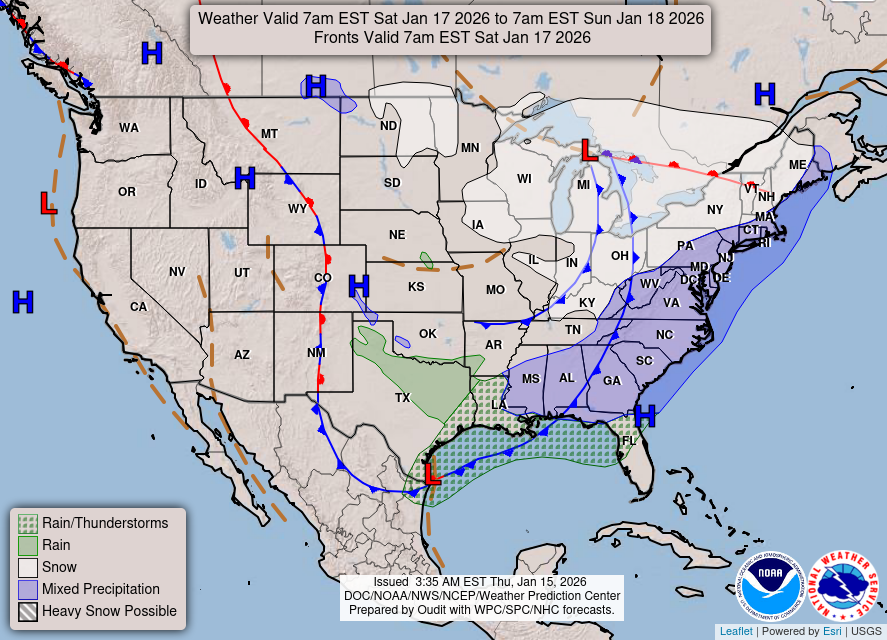
Wintry Weather Heading into the Weekend?

The gusty winds that we experienced today will weaken as we head into the overnight hours. A slight forcing mechanism from the approaching storm system could spark off a few showers across the region tonight. Temperatures throughout the area will be well above freezing heading into tomorrow morning with lows bottoming out around 40 degrees. Cold air advection will filter into the area following a weak cold front, keeping tomorrow’s high temperature into the middle 40s. Clouds will stick around throughout the day ahead of our next storm system.

Quick-hitting upper-level shortwave trough will swing through the Ohio River Valley Friday. The National Weather Service out of Louisville, KY issued a Winter Weather Advisory for Warren County as this system could bring the area a quick-hitting round of wintry weather.

High temperatures tomorrow drop off quick as cold air advection noses into the area dropping temperatures around the area to right around the freezing mark. If temperatures drop below freezing, that could lead to a quick changeover from rain to some sort of frozen precipitation. Model guidance hasn’t been consistent on the magnitude of cold air filtering into the region and when that changeover could happen. As we get closer to the event, model guidance should have a good grasp on the amounts of freezing precipitation. As of now, model guidance is spitting out a light glaze to possibly a .10 of an inch of ice.

The wintry precipitation will exit the region before the daylight hours on Saturday morning as high pressure builds to the north. Model guidance is indicating at high temperatures on Saturday staying in the middle 30s with partly sunny skies. Another shortwave will impact the region late Saturday night into Sunday bringing back the chance for light precipitation.

The entire area we continue to be in this active weather pattern heading into next week. For further updates visit the WKU Meteorology Blog and White Squirrel Weather.

Friday: Rain likely after 4pm with otherwise mostly cloudy skies, high temperature in the middle 40s.

Friday night: Rain before 3am, changing over to light freezing rain/mix. Low temperatures right around 30 degrees. Little to no ice accumulation expected.

Saturday: Partly sunny, with a high right around 40 degrees.

Sunday: Chance of rain throughout the day, high temperature in the low 50s.

Posted in Kentucky Weather | Comments Off on Wintry Weather Heading into the Weekend?

Valentine’s Day Forecast

What is that bright yellow ball in the sky?

It sure seems like it has been a while since the sun has been visible! Rain has been the story for much of February so far; and some long range models are hinting that the active pattern continues for at least the next week or so.

12Z GFS Model run

Models, such as the 12Z GFS shown above, are signaling the potential for another system to impact us this weekend. This far out it’s hard to tell where that rain to ice/snow line will fall- but it is certainly something to keep an eye on over the next few days. With an ongoing active pattern into the latter half of February, there’s a good chance that we could see some more winter weather before the month is over.

18Z NAM Model Run

Check out that surge of yellows from the south at the beginning of the model run above. That’s a decent warm-up (50’s) for Valentine’s Day, before another cold front passes and it gets cold yet again.

01Z HRRR

Above, the short range HRRR model illustrates gusty winds of about 30-40mph moving into the area by the early afternoon tomorrow. For those in high profile vehicles, take it slow and safe out there on the highways as these winds could make travel difficult. For those delivering Valentine’s Day flowers, do it in the morning and avoid losing them to the wind!

Summary:

  • An active weather pattern continues; chances for wintry precipitation over the next few weeks
  • Southerly winds ahead of a cold front bring milder temperatures and strong winds for Valentine’s Day
Posted in Kentucky Weather | Comments Off on Valentine’s Day Forecast

Good News and Bad News

Well the good news is that the rain is on its way out. The bad, it’s gotten chilly again. We’ve seen it rain all day with quit a few heavy gusts of wind. White Squirrel Weather recorded a gust of 45 mph earlier.

Looking at the surface map, the stationary front that was keeping all that nasty rain around has finally been pushed out of the way. Behind it is the cold front that has today so windy and temperatures dropping.

Satellite also shows most of those clouds being pushed out of the way for a brighter tomorrow.

Thursday is looking to be a nice day for Valentine’s. Towards the night time we do have a 40% of rain.

  • SUMMARY:
    • Tuesday:
      • High: 59
      • Low: 30
      • The rain is on its way out but with it comes the cold. Please continue to watch for flooded roadways!
    • Wednesday:
      • High: 48
      • Low: 37
      • Sunny skies!
    • Thursday:
      • High: 56
      • Low:45
      • Happy Valentine’s!! There will be increasing rain chances into the night but overall it should be a pleasant day.
Posted in Kentucky Weather | Comments Off on Good News and Bad News

The Rain Continues

Grab those umbrellas and rain jackets as it will be a wet one for the early portion of this week. As previously described, Bowling Green and the surrounding area is under a Flood Watch. The flood watch is in effect until Tuesday (1/12) at 12 pm. A low pressure system to our west is bringing a large amount of precipitation being fed from the southeastern Pacific. As the low progresses to the east this afternoon and into the evening, it will bring heavier periods of rain.

Rain this evening and overnight is expected to bring an additional 1 to 2 inches for our area. According to the USA Climate Data, Bowling Green typically receives around 4″ of precipitation for the month of February. This means, this afternoon and tonight alone could bring half of the monthly average amounts. Due to the active pattern of the subtropical jet and polar jet, we have received above average amounts of rainfall for the month of February. As you can see below, heavier rain is expected to arrive late tonight and continue into the first half of Tuesday.

24-Hour Precipitation Amounts (Source: COD Weather)

If you are looking for the “sunnier side of things” hold on for another couple of days as mid week looks to clear up before the rain once again returns.

FORECAST:

Today (1/11): Rain throughout the day. Chance: 100%.
High: 57
Low: 55
Tonight: Rain continues becoming heavier at times overnight and into the early morning hours. Chance of rain 100%.
Tuesday (1/12): Heavier showers possibile for the morning commute then a steady rain continuing throughout the day before moving out in the evening.
High: 59
Low: near 30
Side Note: Winds are likely to be pretty strong Tuesday with gusts of 35+ mph possible in the afternoon.

Posted in Kentucky Weather | Comments Off on The Rain Continues

Sunday: Soaked and not Stoked

We are looking at a strong chance of rain for today, so when going out, pack a raincoat and/or and umbrella. The fuel for today’s rains come from the Southern Pacific, with water vapor content being very high.

Mid-Level Water Vapor (Source: College of DuPage)

The Bowling Green Area is also under a Flood Watch, which will range from tonight until Tuesday afternoon. Rains from today until Tuesday can bring a flood danger for a vast majority of Kentucky. The map below is a weather outlook map from the National Weather Service in Louisville.

Weather Outlook Map (Source: NWS Louisville)

Remember to stay dry! Highs today will be in the upper 30’s with lows in the upper 20’s. Monday will have similar conditions as Sunday, with highs in the upper 50’s and lows in the lower 40’s. The main question here is when will the rain chances end. Projections are showing the rains could end Tuesday afternoon, with highs in the mid 50’s and lows in the mid-lower 30’s.

6Z GFS SLP and Precipitation (Source: College of DuPage)

Forecast:

Sunday: 100% chance of rain, High: 40, Low: 30

Monday: 100% chance of rain, High: 59, Low: 43

Tuesday: Rain ending in the afternoon, High: 56, Low: 34

Posted in Kentucky Weather | Tagged , | Comments Off on Sunday: Soaked and not Stoked

Short Sunny Saturday

Due to a high pressure centered over Wisconsin, our break from the rain will continue; however, this break will be short lived as there are calls for rain towards the end of this weekend.

14Z SFC Observations (Source: College of DuPage)

Increasing cloudiness will be the call for our Saturday. Colder conditions will persist, with the highs in the upper 30’s and lows below freezing in the upper 20’s. With complete cloudiness for Sunday, there is a chance that we will return to the rainy conditions that once plagued us three days ago. Highs will be in the low 40’s, with lows in the lower 30’s.

6Z GFS SLP and Precipitation (Source: College of DuPage)

It appears as if the presence of rain will be a long one, persisting from Sunday morning and into Monday night. If the projected rain event shown above will be similar to the one last Wednesday and Thursday, there will be a return of a potential flood danger. Highs for your Monday can reach the low 60’s, with lows in the lower 40’s.

Forecast:

Saturday: Increasing cloudiness; High: 39, Low: 29

Sunday: Periods of rain starting in the morning; High: 41, Low: 32

Monday: 100% chance of rain; High: 61, Low: 43

Posted in Kentucky Weather | Tagged | Comments Off on Short Sunny Saturday

Dry and Cooler Conditions for Now…

Flash Flood Warnings continue for several rivers in our region. Warnings for the Green River at Woodbury and at Rochester continue until Monday at 12:20 AM CST. Here is a look at the river gauges for those two spots.

Green River Gauge Forecast at Woodbury.
Courtesy of NOAA.
Green River Gauge Forecast at Rochester.
Courtesy of NOAA.

Flooding at Woodbury and at Rochester is expected to stay within the minor range. This means that low laying fields, properties, or roads along the Green River at these two locations could experience some minor flooding until late Monday evening as the river settles back below flood stage.

Setup:

A cold polar airmass descends on the region for the start to your weekend bringing much cooler temperatures than what we started with at the beginning of the week. That airmass moves out of the region by Sunday, placing us in the return flow region of the high pressure. This will warm our temperatures slightly but also will bring about our next chance of rain as well. Rain showers will start shortly after daybreak on Sunday, and will be on the increase throughout the day. Prior to the onset of the rain on Sunday temperatures could cause a brief period of glaze to form on elevated or metal surfaces. The main threat for this looks brief and sets up to the west of I-65. Warm air aloft will then quickly transition the precipitation type to all rain. Another brief period of glaze could be possible for the far northern counties as the main shield of rain moves out. But this depends on several factors including how much moisture remains and what will the temperatures be around that time? Unsettled weather continues into the start of the workweek.

Forecast:

Tonight- Lows in the 20s under Partly Cloudy skies.

Saturday- Sunny, Highs in the low 40s with windchills in the teens possible.

Saturday Night- Lows hover around 30 degrees with increasing clouds ahead of the next system.

Posted in Kentucky Weather | Comments Off on Dry and Cooler Conditions for Now…

Chilly Air Invades the Region

Rain showers will move out of the area within the next hour or two, with cold air filtering into the region during the night time hours with morning lows on Friday in the lower 20s. Temperatures behind the cold front will drop rapidly as high pressure moves into the area leaving us with clear skies all day on Friday. Highs on Friday will top out in the lower-to-middle 30s.

Above: NCEP SREF Plume 3 hourly Temperature

Thanks to the mostly clear skies and light winds, temperatures will drop to right around 16 degrees Friday night into Saturday Morning. With high pressure over the region, Saturday will be similar to Friday but with slightly warmer temperatures. Temperatures on Saturday will struggle to reach the 40 degrees mark. Late in the day on Saturday and heading into the overnight hours, the region will experience a shift in the winds that will be coming in from the southeast. Cloud cover will move into the area during the overnight hours on Saturday into Sunday morning thanks to a disturbance that will swing through the Midwest. As the storm system moves into the Ohio River Valley, precipitation will break out across the area during the morning hours on Sunday. The temperature on Sunday will top out around 45 degrees.

Above: Precip Type, Mon 2019-02-11 00z

An active weather pattern will be expected during the first half of next week as a storm system moves back into the region. Visit White Squirrel WX or WKU Meteorology Blog for further updates.

Friday: Sunny skies, chilly with temperatures right around 34 degrees.

Friday Night: Clear skies, chilly with a low of 17 degrees.

Saturday: Mostly sunny with a high of 40 degrees, winds will be light.

Sunday: Rain after 8am with cloudy skies. High near 45 degrees. 

Posted in Kentucky Weather | Comments Off on Chilly Air Invades the Region

Rainy but Warm!

Please make sure you step outside for a bit today because it is nice! Right now we have a stationary front laying on top of us which will help that warm weather stay with us for the next couple of days. There are quit a few clouds in the sky right now, but the sun still has plenty of room to shine through!

There are still a few pop up showers that could make their way into the area. Temperatures today have skirted right around 70. This unfortunately is not something that will last as will be felt Friday. We will see rain chances increase into tonight and especially into tomorrow when thunderstorms are possible. With the rain this week do keep an eye on the potential for flash flooding. Tomorrow and Thursday seem the most likely for any flash flooding, so be careful and don’t drive into any high waters. Temperatures will hit a high around 70 again tomorrow and Thursday. A cold front on the surface will bring the forcing necessary for a thunderstorm. On the backside of that cold front will be chilly temperatures for Friday.

Day 3 image not available
Thursday’s weather
  • Summary
    • Tuesday:
      • High: 71
      • Low:60
      • Precipitation: A few showers could still be seen especially going into later tonight.
    • Wednesday:
      • High:69
      • Low:62
      • Precipitation: Showers along with a chance for some storms
    • Thursday:
      • High:71
      • Low:25
      • Precipitation: Some showers with a better chance for storms. Keep an eye out for flash flooding!

Stay safe and have a good week everyone! Happy Weatherpersons Day to all my fellow meteorologist! Thank you to everyone (professors and professionals) who have helped us newbies get into and more comfortable with the field!!

Even the atmosphere is feeling the love!
Posted in Kentucky Weather | Comments Off on Rainy but Warm!

A Gloomy and Wet Work Week Ahead

Happy Monday to everyone! If you haven’t already, grab an umbrella on your way out of the door this morning. Rain showers will be scattered throughout the day. Along with the occasional shower, expect those temperature to be pretty comfortable with above average temps for this time of the year. Below is the latest High Resolution Rapid-Refresh model run at 14z (HRRR).

HRRR at 14z (Source: COD Weather)

As you can see, scatter showers are expected to pass through the south-central KY region this afternoon. The chance of rain increases into this evening and the overnight hours. Overall this week, expect this type of weather to continue. Much of the work week will be mostly cloudy with scattered showers. The greatest chance of rain will be mid week (Wednesday and Thursday). Once that system moves out the cold front associated will bring high’s back into the 30’s for your Friday.

FORECAST:

Today (1/4): Mostly cloudy with scattered rain showers throughout the day. Chance of rain 50%.
High: 65
Low: 52
Tonight: Chance of showers increasing with light rain expected this evening and overnight. (chance of rain 60%)

Tuesday (1/5): Mostly cloudy with a chance of a shower or two throughout the day. Chance of rain 30%.
High: 68
Low: 58

Posted in Kentucky Weather | Comments Off on A Gloomy and Wet Work Week Ahead