WKU Storm Chase – Day 1

After a long day of travel out to Hays, Kansas, Tuesday was our first real opportunity for chasing storms. After looking a the data the night before, it was clear that the only real opportunity to see storms would be well south- possibly in the Texas Panhandle. Knowing the long distance we’d have to travel, we jumped in the van at 8am and conducted a quick forecast discussion in the van to pinpoint our target.

This would prove to be a tough forecast due to the lack of upper level winds throughout all of the Plains. Basically, we were chasing a pocket of winds at the 500mb level. Models suggested a pocket of winds would move across the Texas Panhandle by late afternoon along with a shortwave disturbance. This shortwave would provide the lift needed for initiation. The region was under the influence of a very weak surface low which provided light southwesterly flow across the panhandle. With the dry line set up in eastern New Mexico, this is where initiation of the storms would most likely take place. Taking distance in mind though, I suggested a target just north of Amarillo, Texas. This is where a sort of psuedo-triple point could potentially set up with the low, cold front, and dry line. However, our expectations weren’t too high with all things considered.

A surface analysis of the the potential chase spot

As we reached Amarillo in the mid-afternoon, we decided to head west toward where the storms were developing because waiting would most likely bring messy, multi-cellular storms rather than single cells. This is because of the lack of low-level shear within the area. Heading toward the storms proved to be the best decision as we reached a pretty cell just west of Tucumcari, NM.

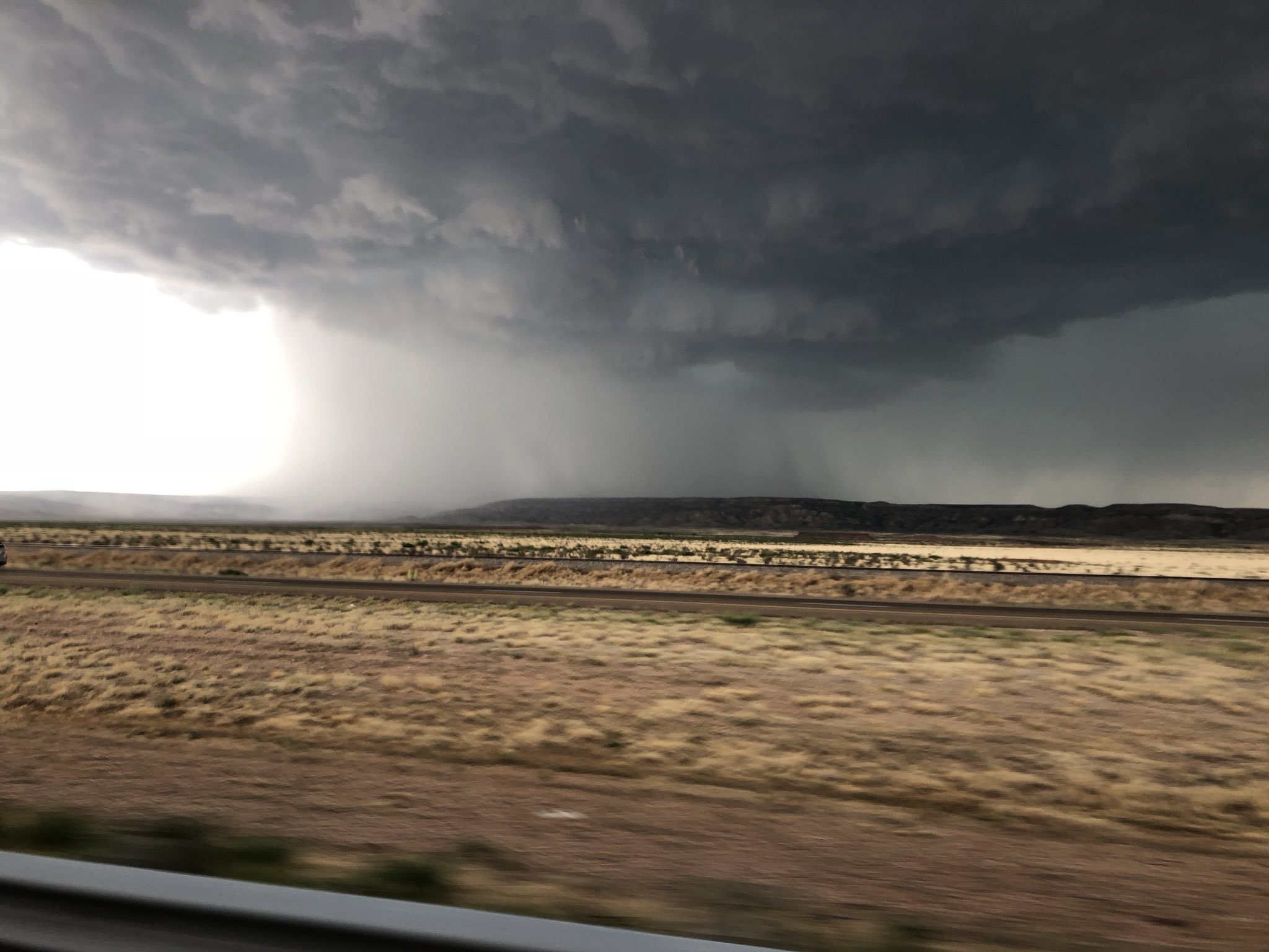
A severe storm just west of Tucumcari, NM

We chased this cell as it headed eastward back toward the Texas Panhandle. We were able to get a few unique views of the storm including from the back side where we could feel the outflow winds. This was the first time for many of us in which we experienced the howling winds associated with the RFD. We also saw many picturesque cloud-to-ground lightning strikes that had many of us in awe.

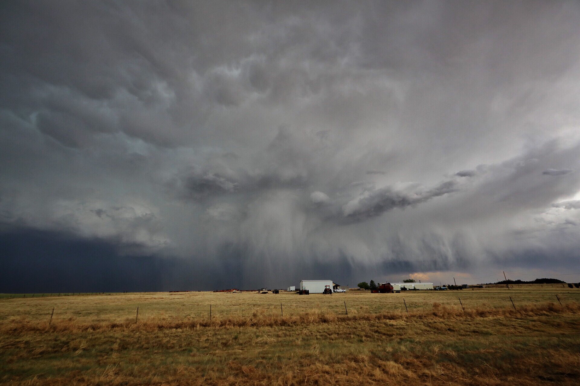
The same cell near the New Mexico and Texas border

When the storms began merging and becoming more of a messy structure, we decided to punch through the storm and make a dash toward Amarillo where we would stay the night. But first, we had to continue the tradition of stopping at The Big Texan. While this tradition is usually saved for groups that have seen a tornado, we could not pass up the opportunity for great steaks and a good time! So, we need to catch a tornado by the end of this trip to be fair to the other groups…

A rainbow outside of The Big Texan

Overall, it was a great day that actually exceeded our expectations. We are looking forward to seeing what else the Plains has in store for us over the next two weeks!

Posted in U.S. Weather | Tagged , , , | Comments Off on WKU Storm Chase – Day 1

Your Winter Break Weekend!

I have enjoyed forecasting the weather this week. It was interesting throughout and kept me on my toes at the beginning.

It has been frigid cold the past couple days with lows yesterday getting down into the 20s.

The Solomon Islands experienced a 7.8 magnitude Earthquake, leaving Hawaii in a Tsunami Watch.

Forecast 12-9-16

Forecast 12-9-16

Nothing super eventful will happen today as we are set in a high pressure area. A front out west is driving winter weather from Oregon down south into Colorado. We also see snow possibilities to our north in Indiana and Ohio. Arctic winds from the north will make sure we stay cold all day.

Forecast 12-10-16

Forecast 12-10-16

As we move into Saturday, our winter weather chances increase. Possible snow will move more south towards Kentucky and we will stay in the cold temperatures. Eastern Texas can expect a rainy Saturday.

12-11-16

12-11-16

As we get into Sunday the winter weather chances move even closer to Kentucky. This is where it gets interesting and more difficult to forecast. Winter weather is tricky, even the best forecasters can be caught off guard. With my skills, I will keep an eye of freezing levels in our area.

Expected as of right now, a band of freezing rain will be in between regular rain to the south and snow to the north. This is al happening to our north, depending on the direction of the wind and frontal movement will determine if we get any of this winter weather.

As for your weekend numbers:

Tonight: A frigid night ahead with a low of 20 degrees. This could be lower in localized areas.

Tomorrow: A little warmer with a high near 40 degrees. Low around 27.

Sunday: Snow possible in the early morning that will transition into rain. High around 47 degrees. 50% chance of rain. Low around 43. Higher rain chances in the night.


It has been a blast writing for the blog this semester! Have a safe winter break and a fantastic holiday season!

Cheers.

Posted in Kentucky Weather | Comments Off on Your Winter Break Weekend!

Mid-Finals Week Forecast

Forecast 12-7-16

Forecast 12-7-16

For the first time in a while we have seen the sun  today! Wouldn’t you know it?! After what seemed like a month of straight rain and gloom we finally get a sunny day.

A sunny day right before what is going to be the coldest days we have seen this season.

Yes, starting tonight we are going to see some unseasonably cold temperatures. After Monday’s post the possible winter weather I discussed coming Thursday has dried up with all models agreeing to drier conditions. However it is leaving us with bitter cold temperatures.

After the final cold front passed through, high pressure set up in our region. Even though it is not as sensational as it once was with the possibility of snow, it’s still going to be very cold for our region this time of year.

The cold temperature will be fueled by northerly winds bring that arctic air into Kentucky Thursday into Friday.


The numbers:

Tonight: It starts us off with some cold temperatures tonight going into Thursday. Low of 27 degrees.

Tomorrow: High of 35 expected which is ten degrees cooler than today. Low of a frigid 18 degrees.


I apologize for the lateness of this blog post! I will return Friday with a summary of this week and your weekend forecast.

Cheers.

Posted in Kentucky Weather | Comments Off on Mid-Finals Week Forecast

Cold Finals Week

If you’re reading this and happen to be a student at WKU, happy finals week! If you’re not a student, I hope you have a good week. It is going to be cold.

Keeping up with the forecast discussions released by the NWS Louisville over the past couple of days, this week is going to be interesting.

My posts this week will all build on one another, I may also post more than I usually do as I get more information on the forecast. Plus, I have more free time, so why not?

Right now Bowling Green is sat in the middle of some very fast upper level winds. These winds are from the south and as I move down the atmosphere, they stay coming from the south until I reach 1000mb. At 850mb there is a center of high pressure directly to our northwest that is going to hold our cold temperatures for today.

You have probably heard the term “arctic blast” over the past few days. Basically upper level winds form the north are going to move in our direction, bringing very cold temperatures. What fun.

As for today, it’s going to be very gloomy and you should not rule out rain. Rain is possible all day so be prepared. Here is a map:

WPC Forecast Map 12-5-16

WPC Forecast Map 12-5-16

Even though the colors aren’t correct, it still tells you the good story. Possible rain as the remnants of that cold front finally dissipate away. Leaving us cold and wet, sometimes the weather is mean. It does not show the center of high pressure that is just to the north of Paducah, but that’s because it is only seen at 850mb and below, it is fairly insignificant.

Now here are some more maps, I usually don’t do this but since the weather is interesting, I want to go into more detail.

WPC Forecast Map 12-6-16

WPC Forecast Map 12-6-16

Yay, more rain. A low pressure system will power a cold front, bringing us more rain. Remember those winds from the south, those carry moisture from the Gulf Coast, you can also thank those winds for more rain! You also start seeing winter weather showing up close to Kentucky, freezing rain possible in West Virginia.

One more map and I’ll get on with today’s numbers.

WPC Forecast 12-7-16

WPC Forecast 12-7-16

That snow is just going to cuddle up right next to us. As of right now, the models are in disagreement with what is actually going to happen. Fore Wednesday and Thursday here is what the models are suggesting. Now, only time will tell and I will give more details with a much more confident prediction as we get closer.

GFS(Global Model): Running fairly fry with precipitable water which is a good representation on how moist the atmosphere is. It is also running dry with accumulated precipitation

NAM(North American): Running moist on both precipitable water and accumulated precipitation.

I do not have access to the Euro Model(ECMWF) however, from forecast discussions I have read from the NWS it is also running moist.

NOW the numbers!

Today: High of 50 degrees with continued chances of rain.

Tonight: Low of 46 degrees and it will rain tonight.

Tomorrow: High around 50 degrees. More rain likely.

Thanks for reading, I will post more as more information is gathered.

Cheers.


Posted in Kentucky Weather | Comments Off on Cold Finals Week

Monday & Tuesday Storm System

The atmosphere will really be cranking up Monday evening and into Tuesday with the approaching trough of low pressure out of the NW United States. Currently this trough is merging the polar and subtropical jet streams in the Four Corners region and has already induced cyclogenesis over the central Great Plains. This storm system will continue to evolve and propagate eastward toward the Ohio Valley today and tonight. Tomorrow, more upper-level wind energy and difluent flow will kick off precipitation across the the State of Kentucky.

Below are a series of graphics generated from the latest NAM run (12 Z) illustrating the dynamics of this system at varying layers of the troposphere. These are valid for 00 Z tomorrow evening (6 p.m. CST):

  • 300 hPa winds and heights – notice the large trough axis and jet streak to our SW as winds approach ~165 kts (~190 mph), as well as the difluent flow helping to aid large scale ascent.
  • 500 hPa relative vorticity and heights: – Here you can see the vort max (curvature vorticity) over North Dakota associated with the closed low, as well as vorticity maxima  (shear vorticity) associated with wind shear due to the jet streak mentioned earlier. Positive vorticity advection (PVA) will also aid lift with this system.
  • 700 hPa heights and vertical velocity – The dynamics of this system will certainly favor synoptic scale lift, as well as localized convection to the south. Lift = clouds and precipitation for the area.
  • 850 hPa winds and heights – In response to the upper-level jet streak, a strong low-level jet (LLJ) will develop across the area. Here, winds are forecast (by this NAM run) to be ~80 kts! The LLJ serves as a pipeline for low-level advection of warmer air and higher moisture content, necessary for storms and rainfall, which we desperately need.
  • Surface MSLP, 1000-500 thickness, simulated precipitation: – Now you can see how the dynamics in the low, mid, and upper-levels of the atmosphere come together to create weather in our world. Here you can see the low over the Dakotas and trailing frontal boundary down into the Ohio Valley. The warm air and moisture advections ahead of the front are lifted via the warm conveyor belt and eventually result in the formation of rainfall.

In short, we have a dynamic system coming our way tomorrow. We will certainly see some much needed rainfall for the area, as well as some pretty gusty winds. With the LLJ parked over Bowling Green in the evening, surface wind gusts could easily approach the 40 mph range.

We should expect ~1″ of rain up to ~2″ in some places with temperatures getting up and around the 60 degrees. However, the cooler air won’t make its way into the region until Wednesday evening as the trough axis takes its time moving eastward. This is partly due to the upper-level ridge of the SE Florida coast and the digging nature of the trough out west. Hopefully this system puts a good dent in the drought conditions for the area and puts and end to the wildfires across the Appalachians.

Bring your rain jackets to work and school on Monday, and be prepared for additional rainfall on Wednesday as another round of PVA & other upper-level dynamics attempt to make their exit.

Posted in Kentucky Weather, U.S. Weather | Comments Off on Monday & Tuesday Storm System

Drought Conditions Upgraded, Rain Soon?

Another update to the drought conditions just released and puts a good portion of southeastern KY in the D3, or extreme drought, category. This came in just before that little bit of rainfall relief was received across the state yesterday, but simply not enough.

Below is the Multi-Radar Multi-Sensor (MRMS) platform displaying 24-hour QPE:

MRMS QPE estimated rainfall - Courtesy NOAA/NSSL

MRMS QPE estimated rainfall – Courtesy NOAA/NSSL

Despite this, here’s the latest drought condition map for the state. As you can see above, little precipitation fell across the state, but this was expected.

Drought Monitor for KY

Drought Monitor for KY

As mentioned in the last post, active jet stream conditions will favor cyclogenesis and low pressure systems over the Ohio Valley within the coming days. Ideally, warm sector conditions and cold fronts will produce rainfall, but its uncertain exactly where and how much. Below is an image from the GFS Ensemble showing forecast QPF:

It looks like a  range from around 1″ to 1.75″ is expected across the state, which would be very beneficial to drought and possible wild fire conditions in the Commonwealth. A good portion of this is expected to arrive on Tuesday when an amplified trough approaches from the west parenting a low pressure system.

Latest GFS runs below help to paint this picture; 300 hPa winds, 500 hPa vorticity, MSLP & PWAT valid for 12 Z Tuesday:

This will be a fairly dynamic system which has good potential for bringing some very needed rain to the state, hopefully this pans out!

Otherwise, we remain in the typical up and down jet stream pattern we typically see this time of year. Cold -> warming -> precipitation -> cold -> repeat. Hopefully this puts a dent in the drought conditions soon, for us, and much of the southeast US as well. Fingers crossed!

HAPPY THANKSGIVING FROM WKU METEOROLOGY

Posted in Kentucky Weather, U.S. Weather | Comments Off on Drought Conditions Upgraded, Rain Soon?

Dry KY Conditions, But Relief Coming

Drought conditions over the past several days haven’t had any improvement despite occasional light rain episodes, but it appears a more active jet stream will help to put a dent in the rainfall deficits across the state, starting tomorrow. A trough is working its way from the west and is setting up a an area of low pressure which will send rain across the Ohio Valley.

Currently, the drought situation for the state of KY can be seen in the graphic below:

Current KY Drought Condtions

Current KY Drought Conditions

Upper level dynamics are helping to provide beneficial rainfall to our area though. Currently a trough of low pressure and surface low are propagating across the central US and entering the Ohio Valley:

The below graphic displays the latest NAM run and it’s thinking on surface conditions and precipitation tomorrow morning, as compared to the same time as the image above ^

Generally it is expected that most locations receive about a .25″ of rainfall with this approaching system. Not a drought buster, but perhaps and aid to wild fire situations to our east.

As mentioned before, the jet stream is becoming more active after a prolinged period of anomalous heat and dryness, as well as above average heights. As seen below, another upper-level system can be seen entering the Ohio Valley by 00 Z Friday:

This particular piece of energy isn’t expected to bring any additional rainfall to the area, but is a sign that supports the more active pattern we need in order to improve the drought conditions longer-term. Currently, the GFS is suggesting additional precipitation from more low pressure systems into next week.

Hopefully this week I will provide some additional details on approaching systems and hopeful outlooks on improving drought conditions across the area. until then, have a great Thanksgiving!

Posted in Kentucky Weather | Comments Off on Dry KY Conditions, But Relief Coming

Warm and Wet Today, Cool and Dry Weekend

Afternoon everyone! Another week has come and gone as have the temperature swings. As of this posting the current temperature ranges from 70 to lower 80s across the Mid-South region, particularly it is 77 degrees in Bowling Green (kymesonet.org). High temperature are expected to range between mid to upper 70s into the lower 80s for most of the region. The outlook for today was sunny with increasing clouds and rain during the afternoon to evening hours.

SPC Categorical Outlook for Severe Storm Potential for November 18, 2016 20Z

SPC Categorical Outlook for Severe Storm Potential for November 18, 2016 20Z

Currently there is a surface low pressure system located in northern Michigan near the Great Lakes area moving north east with a cold front that stretches from the Great Lakes region down into Texas, Arkansas, Louisiana area.

SPC/NWS/NOAA Forecast Map for November 18, 2016 20Z

SPC/NWS/NOAA Forecast Map for November 18, 2016 20Z

This cold front has a rain band associated with it. The movement of this front is driven by the trough axis that is moving through behind the front pushing the air mass across the region. This system has slight severe weather potential due to some measurable cape values, areas with potential energy available, a conditionally unstable atmosphere were areas with more instability bringing greater rain amounts and severe weather. Also a dangerous wind speed situation with winds at the 10 meter level around 20 mph sustained with gusts of 40 to 45 mph possible, indicating a severe storm situation. Expected cumulative rain for this system over the next 6 to 12 hours is around 0.5 inch to 1 inch.

In order these maps show the upper level trough location identified by dip in isotachs (solid lines). The next map shows the CAPE measures associated with this rain band of areas measuring between 500 (purple) to 1000 (blue) Joules of potential energy. The third map shows the 10 meter high wind gusts., where the purple line is increased wind gusts from the frontal passage in due to the convergence of wind to the surface level low.

Upper Level Wind Speed Map Showing Trough location at 3Z November 19, 2016 (College of Dupage Model Analysis)

Upper Level Wind Speed Map Showing Trough location at 3Z November 19, 2016 (College of DuPage Weather Analysis Tool)

Mid Level CAPE and Bulk Shear (College of DuPage Weather Analysis Tool)

Mid Unstable CAPE and Bulk Shear (College of DuPage Weather Analysis Tool)

10 Meter Wind Gusts (College of DuPage Weather Analysis Tool)

10 Meter Wind Gusts (College of DuPage Weather Analysis Tool)

Outlook for Tonight and through the weekend:

Tonight: Rain showers and thunderstorms before 3am with rain chances afterwards. Cumulative rain totals range from a tenth of an inch to a half inch possible, with areas

Saturday: Rain showers leaving area early morning, with conditions becoming Sunny and clear. The high temperature will be around 43 degrees and wind speeds will range from 5 to 15 mph throughout the day originating from the northwest.

Saturday Night: Clear with low temperature of 26 degrees and winds from the west at 5 to 10 mph.

Sunday: Clear and Sunny with high temperature of 42 and winds from the west at 5 to 10mph.

Sunday Night: Clear and cool with a low temperature of 26 degrees and winds from the west at around 5 mph.

Enjoy the weekend everyone!

Posted in Kentucky Weather | Comments Off on Warm and Wet Today, Cool and Dry Weekend

Quick Warming Trend

Evening again! Today was a bit warmer than the past week and a half! Today’s high for Bowling Green was 73 degrees according to the Kentucky Mesonet (kymesonet.org). Look for the trend to continue as the warm front moves north of Kentucky and the cold front located in the mid west moves towards the area reaching the Mid-South region by the weekend bringing chances of rain Friday night into Saturday morning.

NWS National Forecast Map for Nov 16, 2016

NWS National Forecast Map for Nov 16, 2016

Outlook through Thursday Night:

Tonight: Calm winds, clear skies with a low temperature around 46 degrees.

Thursday: Sunny with a high of 73 degrees and wind from the south around 10 mph.

Thursday night: Clear with a low of around 53 degrees and wind from the south around 5 mph.

Posted in Kentucky Weather | Comments Off on Quick Warming Trend

Another Fall Like Week

Evening everyone, another Monday has come and gone but there is only 6 left in 2016! Since the start of the month high temperatures in Bowling Green have decreased from the mid 80s at the start of the month to the mid to lower 60s for the past week according to the Kentucky Mesonet. The fall weather seems like it might remain prevalent across much of the Mid-South region. With the freeze warning overnight last night it very much seems like winter is approaching. Today’s high temperature for Bowling Green was 65 degrees and the previous overnight low was 28 according to the Kentucky Mesonet.

NWS National Forecast Map for 11-15-16

NWS National Forecast Map for 11-15-16


Overnight expect a low pressure area associated with an approaching cold front to move through the Mid-South area into the east coast and high pressure moving into the area. With the frontal boundary passing there is a small chance that precipitation could form. The chance of rain is might accumulate trace amounts if any precipitation occurs. Expect not nearly as cool temperatures as last night due to the clouds keeping some of the solar radiation in the atmosphere.

Here is the forecast through tomorrow night:

Tonight: Low of 40 degrees, calm wind, and increasing clouds. Enjoy the supermoon before the clouds roll in.

Tuesday: Clouds decreasing throughout morning hours becoming sunny with a high of around 64 degrees and light 5 mph winds coming from the west.

Tudsday Night: Mainly clear with low temperature around 40 degrees, with light winds coming from the west.


Posted in Kentucky Weather | Comments Off on Another Fall Like Week