Chance for rain…Spring like conditions by the weekend!

Wednesday started out as a breezy but cool day across the area.  Plenty of sunshine with southwesterly winds around 5-10 mph gave a brisk chill to the air, but quickly warmed up into the low 50’s across south-central Kentucky.  Through much of the morning and early afternoon hours, sunshine filtered in over the region, but increasing clouds from the southwest has since moved in as overcast conditions have began to take over.   High pressure is currently situated over the Great Lakes region and will continue its progression towards the east.  Tightening pressure gradients between the stout high to the north and deepening low pressure system to the south has been increasing easterly winds across southern Kentucky.  Into the evening hours, winds are expected to settle down a bit as relative humidity values will rise.  Clouds will continue to thicken and lower, especially over central and south-central Kentucky.  Overnight lows are expected to be cold with temperatures dropping into the low 30’s.  Areas to our north could see slightly colder overnight lows as clouds will be slower to move in, allowing temperatures to drop a few degrees below the freezing mark.

fill_98qwbg

NOAA/HPC precipitation forecast (Day 1-2) valid for Thursday 00Z – Saturday 00Z.

Looking ahead for tomorrow, temperatures will once again start off very cool, but should quickly warm up into the low 50’s for southern Kentucky where cloud cover and approaching showers will keep temperatures slightly cooler than areas to our north.  Both the GFS and NAM models continue to trend the system tracking to our south as the Tennessee Valley Region and points southward will see the best chance for precipitation.  Areas along southern Kentucky should see rain showers filter into the area, but should remain light at best.   The HPC suggest that the broad area for heavier rain will occur to our south and eventually to the southeast and along the eastern coast.  Counties along the KY/TN border will see the best chance for showers.

The aforementioned high pressure will continue to move off towards the east coast as any showers along the southern and eastern parts of the state should come to an end as winds begin to back towards the north by Thursday evening.  Thursday night should feature a rather calm, clearing night with a low around 40 degrees.  Skies should begin to clear throughout the overnight hours and into Friday morning, as the long awaited arrival of spring will finally impact the region.  Highs for your Friday are expected to reach the low to mid 60’s under mostly sunny skies! Winds should remain light and from the north around 5-10 mph!


Posted in Uncategorized | Comments Off on Chance for rain…Spring like conditions by the weekend!

Weekend Forecast

Well, this week has been interesting, but we are on the up and up temperature wise.  Today was a gorgeous day with temperatures in the 50s.  These should continue to go up to the mid to upper 50s by tomorrow.  This is all because of a high pressure system just to the west of Bowling Green.

temps

Now this weekend we are going to see some rain and possible thunderstorms because of a low pressure system sweeping into our area.  This will cause our temperatures to stay relatively the same and may go down a bit. If you look in the second box, the 540 line is clearly to the north of us, so we will see only rain and now snow.  We will see showers throughout the whole weekend.  There is tons of moisture in the atmosphere.

friday night

Weekend forecast:

Friday: Slight chance of showers, high of 53.

Saturday: Showers likely, high of 60.

Sunday: Showers, highs in the low 60s.

Posted in Uncategorized | Comments Off on Weekend Forecast

Weather Rollercoaster


First off, we were under a Severe Thunderstorm Warning this afternoon and with it came some hail.

radar

Photo taken my Landon Oliver in Bowling Green, KY.

Now onto the forecast.   Today we are going to continue to see showers and thunderstorms roll through.  Now as we go through the evening, its going to get a little tricky.  Depending on the temperatures we are going to see a mix of rain and snow tonight, we could see up to a half inch of snow. Then, tomorrow another half inch is possible.

weather

In the top right image, there is a low situated to our north.  Also, notice the line in the bottom right, that is the rain/snow line.  We are going to see small accumulations as we go through the night tonight.  Again, it all depends on the temperatures   Northern counties will likely see more snow. There is tons of moisture and because of the temperature the snow is going to be a wet and slushy consistency if we see any.

Forecast:

Monday: Rain showers likely, could mix with snow.  Highs in the mid 30s.  Could see snow anywhere up to one inch.

Tuesday: Highs in the upper 30s, 30% chance of rain.

Wednesday: Clear skies, highs in the mid 40s.


Posted in Uncategorized | Comments Off on Weather Rollercoaster

Rain to Close the Weekend

Days at a Glance:

Thursday:  High – 39  Low – 18  Winds – 5-7 mph NW  Precipitation – 0%  Skies – Clear

Friday:  High – 49  Low – 22  Winds – 5-6 mph E  Precipitation – 50% widespread rain showers into the evening and overnight hours  Skies – Clear becoming mostly cloudy and overcast by late afternoon

Saturday: High – 52  Low – 33  Winds – 6-8 mph ENE  Precipitation – 100% widespread rain showers in the early morning hours with more scattered, but heavier rain further into the evening and overnight

Sunday: High – 51  Low – 32  Winds – 6-8 mph E increasing to 20-23 mph SW mid afternoon slackening to 15-17 mph NW late evening Precipitation – 80% residual rain as the front moves through the area with total accumulations for both days under one inch


Discussion:

Currently, the temperature at the WKU Farm Mesonet is at 27 F. By tomorrow morning, temperatures will have bottomed out to the upper teens, so bundle up! Tomorrow will be another nice day with temperatures struggling to escape the 30’s. Thursday night will be another cold one in the lower 20’s. Friday will be another beautiful day with a high near 50, but clouds will be increasing throughout the day into the evening. Widespread, but light rain showers will be an increasing possibility into the overnight hours and Saturday morning before tapering off by mid-morning. Clouds will stick around throughout the day with increasing winds until another round of rain impacts the area into the evening and around midnight. This will be more scattered, but intense in nature because it is associated with a cold front compared to the warm front Saturday morning.

GFS 12Z (7 am) surface winds, temperature, and mean sea level pressure Sunday morning. Notice the low pressure system responsible for the weekend rain passing our area, and the cold, northwest winds behind it.

Models are not agreeing very well with total rainfall accumulations, but I’ll keep the baseline at half of an inch with one inch as the limit for the weekend event. With the rain clearing out by mid Sunday morning, skies will clear out by late afternoon with temperatures falling throughout the day thanks to gusty NW winds.

Forecaster: Austin Boys


Posted in Uncategorized | Comments Off on Rain to Close the Weekend

Soaking Rains

Days at a glance:

Monday: High – 67  Low – 46  Precipitation – 100% moderate to heavy rain ending completely by noon with peak intensities around 5-7 am.  Winds – 16-18 mph S switching and slackening to 5 mph WNW by midnight  Skies – Overcast clearing out into the evening


Tuesday: High – 54  Low – 31  Precipitation – 20% rain around midnight Wednesday morning (confidence: 30%)  Winds – 12-17 mph W  Skies – Clear becoming mostly cloudy to overcast into the evening and around midnight


Wednesday: High – 46  Low – 29  Precipitation – 20% rain around midnight Wednesday morning (confidence: 30%)  Winds – 17-21 mph W  Skies – Partly to mostly cloudy


Discussion:

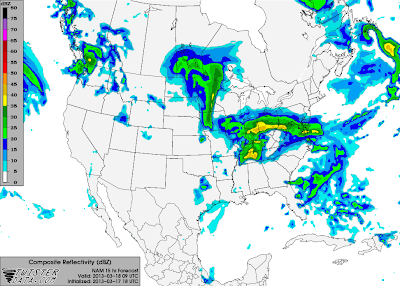
The warm temperatures in the low 70’s we experienced earlier this weekend will reappear shortly into tomorrow before colder temperatures return. A frontal boundary is currently stalled in an east-west orientation across our area. This is the stalled cold front from the beginning of the weekend. Precipitation has been mostly light, but persistent along this boundary today as southerly winds across the deep south bring moisture into the area. With temperatures currently at 42 F in Bowling Green, precipitation will stay in the form of rain as temperatures will remain in the 40’s and warm through the night due to warm air advection preceding tomorrow’s cold front. Rain will taper off overnight as an approaching low pressure system lifts the warm front to the north of our area. Temperatures will rebound nicely into the low to mid 60’s tomorrow under cloudy skies before a cold front sweeps through the area around 3-5 pm. Precipitation associated with this front will come much sooner around early to mid-morning hours before moving out by noon with 5-7 am being the hours of peak intensity. Due to the timing in the early morning, lack of wind shear, and marginal instability, the threat for severe weather will be low with small hail and damaging winds as the primary threats. Widespread and persistent rain will be the main story. Overall, rain amounts could reach up to 1 inch in our area with .65 of an inch as the baseline by tomorrow afternoon.

NAM 9Z (4 am) 3/18 Composite Reflectivity. Notice the precipitation beginning to reach our area in association with the cold front.


Monday night, skies will clear allowing temperatures to fall at or below freezing. Tuesday will be a nice day with a high in the low 50’s. The second feature of concern is a clipper system affecting our area around midnight Wednesday morning. Current sounding profiles for that time are not very promising for anything other than a few hundredths of an inch of rain. Since the temperature will be close to freezing and it is still a few days out, updates will be issued if conditions change.Wednesday will have a high in the mid 40’s with partly cloudy skies.


Forecaster: Austin Boys

Posted in Uncategorized | Comments Off on Soaking Rains

Warm Friday… Then Rain & Storms Possible

The first half of the week has been chilly with an occasional snow or rain shower.  Generally highs have been in the 40s to low 50s. A welcome sight to most however is on the way…. warmer weather! A trough has been in place across the Ohio Valley and much of the eastern United States most of this week and thus temperatures have been cool.  The trough will break down and be replaced by a zonal flow across the nation.  This along with the return flow around a high pressure system near the gulf coast will allow temperatures to warm.  It may be hard to believe since we currently sit in the 30s but we’ll climb to a high in the low 70s tomorrow!  Saturday will also be warm with highs in the 60s, however a cold front will move in during the evening bringing temperatures down Saturday night and into Sunday.  This front will stall out over our area and will be a focal point for rain from Saturday evening though Monday.  The rain won’t be continuous during this time put rather there will be waves of rainfall.  Rainfall isn’t expected to be excessive despite the longevity.  Generally around an inch of rain is expected through Monday night though more may fall in localized areas as a result of a few thunderstorms.

WPC's forecast QPF or precipitation totals through Sunday afternoon.  A clear east-to-west line of heavier precipitation can be seen from MO through KY thanks to the stalled front in the area.

WPC’s forecast QPF or precipitation totals through Sunday afternoon. A clear east-to-west line of heavier precipitation can be seen from MO through KY thanks to the stalled front in the area.

By Monday the stalled front in the area will be pushing back to the north as a warm front just ahead of a low pressure system and cold front which will move through Monday afternoon. At this point in time it does look possible that there could be some storms and some severe storms cannot be ruled out. However confidence in the severity is low at this point as we are still several days out.

By Monday around 1 pm CDT the GFS is clearly showing a strong low pressure system over the upper-Midwest. Furthermore warm moist air is being brought in from southerly winds around this system creating an environment in which storms are possible across south-central KY.

By Monday around 1 pm CDT the GFS is clearly showing a strong low pressure system over the upper-Midwest. Furthermore warm moist air is being brought in from southerly winds around this system creating an environment in which storms are possible across south-central KY.

Nevertheless at least be aware that storms are possible Monday and that further monitoring is necessary as to whether any of these storms will be severe. By Tuesday the cold front will have moved through allowing conditions to clear and temperatures to cool down.

————————————————————————-

Potential Severe Storms Monday… Update (11:26 am Friday)

The Storm Prediction Center has, since the writing of the forecast above, placed all of central Kentucky and Tennessee under an area with the risk of severe storms for Monday afternoon. As more data comes in we will continue to monitor and update you on the severe weather potential. For now at least be aware that Monday has the potential for severe storms.

An area of heightened severe storm potential has been outlined over the areas in red for Monday.

An area of heightened severe storm potential has been outlined over the areas in red for Monday.

——————————————————————–

Daily Forecasts:

Tonight: Mostly cloudy becoming partly cloudy by morning.  Temperatures will hold steady in the mid 30s and may warm to near 40 by morning. Light SE to S winds.

Friday: Partly to mostly sunny with increasing clouds in the late afternoon.  Warm with a high near 72. Breezy with WSW winds from 8-15 mph.

Friday Night: Partly to mostly cloudy with a low near 56. 30% chance of a few showers. Southwest winds from 8-14 mph.

Saturday: Some peaks of sun early before becoming mostly cloudy to even overcast during the afternoon. 30% chance of a few showers/thunderstorms during the afternoon.  Winds from 8-15 mph and switching from the WSW to the NNW through the day.

Saturday Night: 70% chance of rain especially after midnight. Low near 45. 0.1-0.3 inches of rainfall possible. Northeast winds from 5-10 mph.

Sunday: 60% chance of scattered rainfall with 0.1-0.3 inches of rainfall possible. High in the upper 40s to near 50.  Northeast winds from 8-14 mph.

Monday: Low in the upper 40s with a high in the mid 60s. 60% of scattered showers in the morning with thunderstorms possible by the afternoon.

Posted in Uncategorized | Comments Off on Warm Friday… Then Rain & Storms Possible

Heavy Rain Tonight with Cooler Temps to Start the Week

Unseasonably warm temperatures have been welcomed to southern Kentucky this weekend.  Temperatures rose to the low 70s for the first time since late January.  Normally highs should be in the upper 50s for this time of year!  The warmth has been thanks to an upper-level ridge in place over the Ohio Valley.  This has placed a High pressure system to our southeast and a low pressure system and cold front off to our west.  Sitting between these pressure systems has place southern Kentucky in the return flow area which means southerly winds have been bringing in warm and moist air.  Those southerly winds have been strong at times with gusts in excess of 35 mph!

The aforementioned low pressure system and cold front which is now located from Missouri to Texas is pushing east and will be bringing with it heavy rainfall which will start this evening.  A few scattered showers or sprinkles are possible before midnight but most of the heavy rainfall will move in around midnight and continue through midday tomorrow.  The rainfall will be steady to even heavy at times.  In total 1 to 2 inches of rain is likely across all of south-central Kentucky with most of that falling between midnight and 9 am.  After the rainfall moves out tomorrow around midday, skies will remain cloudy and temperatures will continue to cool behind the passage of a cold front.  Temperatures will start in the mid to upper 60s at midnight but will fall through the 50s during the day with 40s by 6 pm tomorrow.

WPC's QPF precipitation forecast valid overnight through tomorrow.

WPC’s QPF precipitation forecast valid overnight through tomorrow.

Beyond tonight and tomorrow’s weather maker much of the rest of the week looks to be fairly quite.  An upper-level trough pattern will works its way in behind this system which won’t allow temperatures to warm back up very quickly.  In fact highs will likely be in the 40s on Wednesday.  Along with the trough some minor disturbances will pass through the Ohio Valley which will bring some clouds and the occasional chance of a sprinkle/flurry primarily Tuesday evening.  Looking on to the later part of the week and on to the weekend, it seems as though the trough will push to our east and a ridge and high pressure system will again move in bringing with it temperatures near 70 again by Friday and Saturday.

Daily Forecasts:

Tonight: Rain, which could be heavy at times.  Temperatures will start in the mid to upper 60s but will fall into the 50s by morning. South winds from 10-15 mph.  Rainfall between 0.75 -1.5 inches.

Monday: Rain likely in the morning ending around midday.  Otherwise cloudy with temperatures cooling from the 50s into the 40s by mid-afternoon. WSW to west winds from 8-16 mph. Total rainfall between 1 and 2 inches (including overnight rainfall).

Monday Night: Cloudy skies could become partly cloudy at times by morning. Light westerly winds with a low near 31.

Tuesday: Mostly sunny becoming partly to even mostly cloudy in the afternoon/evening.  High near 54. West winds from 8-14 mph.

Tuesday Night: Mostly to partly cloudy; a sprinkle/flurry cannot be ruled out early. WNW winds from 6-12 mph. Low near 31.

Wednesday: Mostly Sunny but cool with a high in the mid 40s.  Northwest winds from 5-12 mph.

Thursday: Cold start with lows in the upper 20s.  Mostly sunny with highs in the low 50s.

Posted in Uncategorized | Comments Off on Heavy Rain Tonight with Cooler Temps to Start the Week

Warming trend to continue into the weekend…

Good Friday everyone! Weather conditions have been absolutely great across the Commonwealth as temperatures have continued to warm over the past couple days. After a cold, wintry start to the week, a spring time ending for the weekend looks like a real possibility as surface high pressure and upper level ridging will take hold of our area!  Satellite imagery indicated some lower level stratus clouds earlier this morning  but have since thinned out leaving mostly sunny skies with temperatures reaching the low 50’s over Bowling Green.

Capture

300 mb Heights and Winds map, Valid for Saturday 15Z. Upper level ridge builds over much of the Eastern U.S. as our next trough amplifies to the west over the 4-corner region. Red arrows indicate areas of difluence showing favorable areas for rain and storm development over the Central Plains.

Looking ahead for tonight, clear and cold conditions are expected as the surface high keeps skies generally clear through the evening and overnight hours.  Lows will drop into the low 30’s here in Bowling Green with slightly colder temperatures in the upper 20’s the further north and east you live.

Colder temperatures will kick off our day tomorrow, but should rebound nicely throughout the afternoon as Saturday looks to be the warmest day of the week! Highs in and around Bowling Green will give a spring tease to many as temperatures flirt with the low 60’s across the region.  The highly amplified upper level ridge axis will continue its progression towards the Mid-Atlantic by Saturday night, as we should start to see some higher cirrus clouds work their way in ahead of the next system moving through.  Upstream troughing will continue to amplify  over the Central United States with a spit flow. This will translate to a rainy period beginning late Saturday night while extending into Monday.

—————-

Saturday night: Partly cloudy with a 20% for showers.  Low: 47º. Winds from the south 5-10 mph.

Sunday: Mostly Cloudy, with a warm high of 65º. Chance of rain, 50%. Winds from the south 15-20 mph, with gust up to 30 mph.

Posted in Uncategorized | Comments Off on Warming trend to continue into the weekend…

Nice Sunday….conditions expected to change.

Conditions for your Sunday are expected to clear out nicely as cold but sunny skies prevail.  Morning temperatures have reminded many that winter is hanging tough with lows dropping into the upper 20’s across south-central Kentucky.   A weak shortwave is currently passing overhead as the responsible trough will act to clear out the remaining flurries and embedded snow showers across the region.  A decrease in intensity/coverage is expected with the progression towards our east through the late-afternoon hours.  Skies should continue to clear from west to east as temperatures struggle to reach the mid 30’s for today.

Monday, we’ll begin to turn our attention towards a surface low that will begin to organize during the morning hours as an upper trough digs southeast into the Great Plains.  Isentropic lift associated with the northward advancement of the warm front will help generate bands of light precipitation across the Mississippi Valley tonight, before moving eastward into our area by tomorrow morning.  A light mix is expected although chances for precipitation will be very light as temperatures will warm up quickly over south-central Kentucky.  Highs are expected to reach the low 50’s over our area with temperatures in the upper 40’s towards our north and east.  Conditions will begin to change as we head into the evening and overnight hours.  An elongated trough with an axis extending from parts of North Dakota through central Missouri with an increased southerly flow ahead of this system will help increase moisture values through the overnight hours. This moisture, accompanied by a region of strong isentropic lift passing through will allow a good shot for precipitation as our area could see moderate to heavy rainfall.  Low temperatures across the area are expected to drop into the upper 30’s, low 40’s under mostly cloudy skies.

fill_98qwbg

HPC’s QPF map valid for Tuesday 0Z showing a light-moderate rainfall event over the Ohio Valley Region.

——————

Tuesday: Showers likely. Cloudy, with a high near 52. Southeast winds 5-10 mph. New rainfall amounts 0.10” – 0.25” expected. Chance of precip. 70%

Tuesday night:  Rain transitioning to snow. Cloudy, with a low around 31. West wind 10-15 mph.  Chance of precip. 60%

Wednesday: Rain/snow ending. Mostly cloudy, with a high near 40. Chance of precip. 30%

Wednesday night. Mostly cloudy and colder. Low near 29.

Thursday: Sunny and warmer.  High near 49.


Posted in Uncategorized | Comments Off on Nice Sunday….conditions expected to change.

Recent graduate lands position as Air Force Weather Officer

Recent meteorology graduate Nathaniel Shearer has accepted a position with the Air Force as a Weather Officer, becoming the first WKU Meteorology graduate to follow that career path. Nate will begin his career by attending Officer Training School at Maxwell Air Force Base in Alabama. Read more about Nate here.

Posted in Uncategorized | Comments Off on Recent graduate lands position as Air Force Weather Officer