Beautiful fall weekend and some weather links

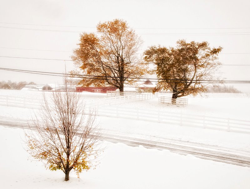
A broad upper level ridge will dominate the pattern over the eastern half of the U.S. for the next several days, leading to picture perfect fall weather over the weekend for the mid-South. Highs in the middle to upper 60s are expected tomorrow and Sunday under mostly clear skies. These clear skies and light winds will provide ideal radiational cooling conditions, so overnight lows are expected to drop down into the middle 30s tonight and tomorrow night. These conditions will also be favorable for cold air drainage into Kentucky’s valleys and large overnight temperature spreads between adjacent ridgetops and valleys. This phenomenon can be monitored in real time using temperature data at the Kentucky Mesonet web site.

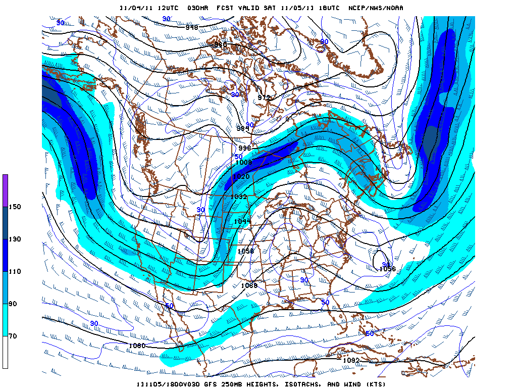
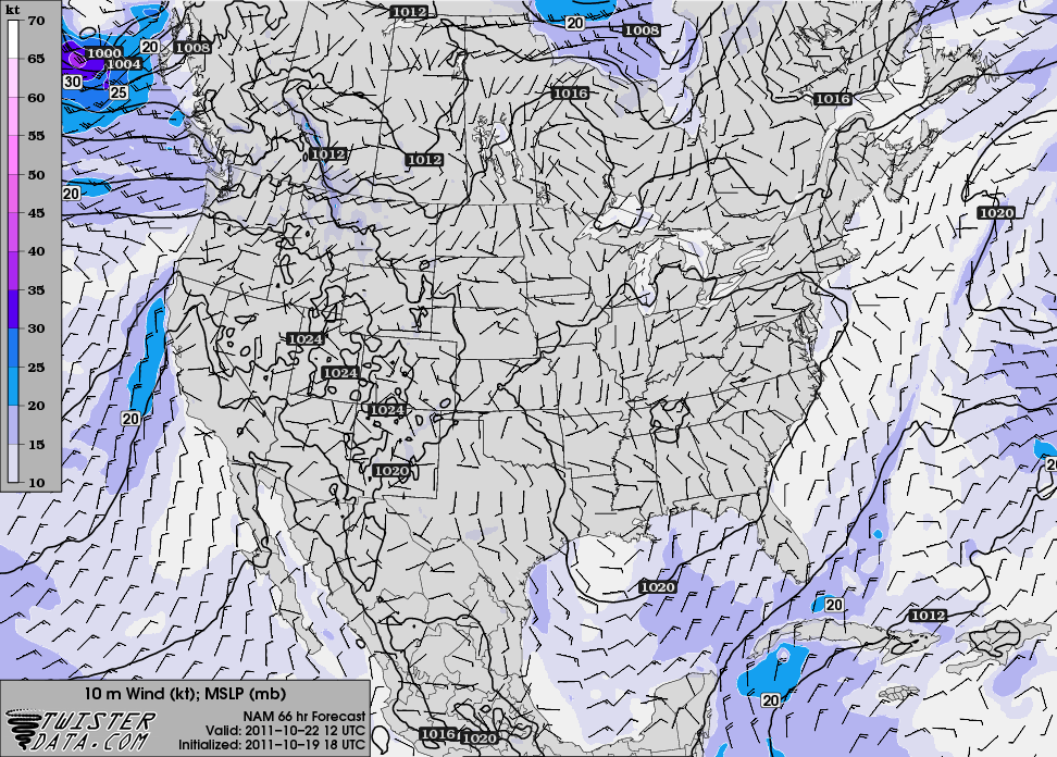
GFS 250 mb height and wind speed forecast for 1:00 PM Saturday, showing upper level ridging over the eastern U.S.


With quiet weather the rule locally and nationally, this is a good time to share a few links to other web sites that may be of interest to readers of this blog. The first link is to the University of Wisconsin’s Cooperative Institute for Meteorological Satellite Studies (CIMSS) blog, which provides selected satellite imagery of current meteorological events and provides a sampling of the numerous applications that satellite-derived products can have in weather analysis and forecasting. Another great source of information on current weather events is Dr. Jeff Masters’ blog at Weather Underground; Dr. Masters does a great job of compiling information and statistics and gears his writing toward a general audience while remaining faithful to the science of meteorology. Closer to home, the WKU StormTopper Network is a great source of information on local weather, and the network also maintains Facebook and Twitter pages. Finally, you can “like” the new Western Kentucky University Meteorology Facebook page to receive meteorology stories of interest in your Facebook news feed.

Posted in Kentucky Weather | Comments Off on Beautiful fall weekend and some weather links

Showers and cooler temperatures tomorrow

After a beautiful start to the week, the weather will turn dreary tomorrow. An upper-level disturbance and associated surface low will progress through the region, bringing widespread rainfall and holding high temperatures in the mid 50s. A few embedded thunderstorms also can’t be ruled out. Anywhere between a quarter and a half inch of rainfall is expected before the system exits the area tomorrow night.

NAM 500mb height and vorticity forecast for 4 PM tomorrow, showing upper level low over the region

After the system clears the area tomorrow night, high pressure will quickly build back in from the west. This will result in a return to pleasant weather and seasonable temperatures for the weekend, with highs around 60 on Friday increasing to the mid 60s on Saturday and Sunday. Nighttime temperatures will not be quite as cold as they were earlier this week, with lows in the upper 30s and lower 40s expected over the weekend.

Posted in Kentucky Weather | Comments Off on Showers and cooler temperatures tomorrow

Quiet Weather Locally; Unprecedented October Snowstorm for the Northeast

Zonal flow aloft and high pressure at the surface will make for a pleasant start to the week in the mid-South. Highs in the mid to upper 60s and lows in the upper 30s are expected today through Wednesday under mostly clear skies. On Thursday, an upper level trough will approach the region from the west, bringing with it a chance for some showers.

One region that did not experience tranquil conditions over the weekend is the Northeast. A freak October snowstorm dropped a swath of heavy snow from West Virginia to Maine Saturday through Sunday, breaking numerous records in the process. For many locations, it was the largest October snowfall on record; a good summary of the storm from Weather Underground can be found here. Some of the remarkable records set by the storm: Concord, New Hampshire received 22.2″ of snow, which was not only the all-time daily and monthly October snowfall record (both previously 3″) but was also the third-largest storm total snowfall on record, regardless of month. Central Park received 2.9″, breaking the previous October record of 0.8″ set in 1925. The big “winner” was Peru, Massachusetts, which recorded a whopping storm total of 32″. An interactive map of snowfall totals can be found here.

Snowtober

Visible satellite animation from Sunday morning, showing departing Nor'easter and fresh snow cover

The early-season timing of the storm meant that it had an even larger impact that these amazing statistics would suggest. The heavy, wet nature of the snow, combined with the fact that many trees still had some or all of their leaves, caused widespread tree damage and power outages throughout the Northeast. At the height of the storm, over 3.1 million customers were without power in the region. The governor of Connecticut declared a State of Emergency, and that state’s Department of Transportation said that the storm knocked down five times as many trees as Hurricane Irene earlier this year. So while the snowfall totals in this storm weren’t quite as high as some of the memorable Northeast blizzards of recent years, the unusual timing and widespread tree damage will ensure that “Snowtober” won’t soon be forgotten.

Snow at the NWS Gray, Maine office, which received 12.9"

Posted in Kentucky Weather | Comments Off on Quiet Weather Locally; Unprecedented October Snowstorm for the Northeast

Pattern Change

Highlights

Trough digging into the eastern U.S. bringing with it much cooler temps

Chances of rain through Fri.

Discussion

Currently, there is a trough of low pressure beginning to dig into the eastern U.S. that will change up the weather for the short term. A cold front currently over northern Indiana will pass through BG late tonight cooling off temperatures and bringing in some much needed rain.  Today’s temperatures will max out around 76 with a slight chance or rain.  The best chance of rain comes tomorrow with temperatures topping out in the mid 50’s for Thursday and Fri and lows staying in the low 40’s.


Posted in Kentucky Weather | Comments Off on Pattern Change

November-January Outlook…according to the CPC

Since the weather is relatively tame today, we will take a moment to discuss the long term outlook leading into this winter.

For long term climatic outlooks The Climate Prediction Center compares various climactic oscillations as well as atmospheric teleconnections, along with some history, to use past events with similar conditions as an analogy to the current state of the atmosphere.

That being said, the CPC has issued there report for the Central Region of the U.S., which includes KY. From following changes in the El Nino/Southern Oscillation. ENSO and the change in Sea Surface Temperatures across the Pacific Ocean, is considered to be one of the major players in sensible weather here in the United States.

From verifications of SST anomolies and forecasted products from this summer. Modeled guidance as well as the CPC both agree that a weak La Nina will persist and strengthen slightly through the beginning of winter.

Based on prior history and the fact that Texas has had record drought, this will likely cause the polar jet to stay mostly across the northern United States and more zonal causing an above normal chance of precipitation in the Pacific Northwest. This is to be taken with a huge grain of salt, as other factors such as the North Atlantic Oscillation can have changes in the sensible weather from week to week. This is a 3 month forecast.

Posted in Kentucky Weather | Comments Off on November-January Outlook…according to the CPC

Chilly and windy conditions to persist into weekend

The upper level trough currently responsible for the cloudy and wet conditions across the state of Kentucky will continue to keep clouds overhead throughout the day today and most of the day on Thursday.  A stray shower or two cannot be ruled out as moisture continues to wrap around the deepening cyclone at the surface on Thursday with rain chances diminishing throughout the day.  Highs Thursday look to remain slightly cool in the mid to upper 50’s. Into the afternoon on Thursday high pressure will begin to build in behind the surface trough and be the dominating factor over the coming weekend with lows reaching the mid 30’s.  Expect highs in the lower 60’s this weekend with lows approaching the freezing mark to mid 30’s.  Temperatures will be comfortable during the day; but will cool quite efficiently under clear skies in association with a dry mid-level atmosphere and northwest flow in the mid-levels.  A frost advisory may be issued into Saturday night and Sunday night as the cold air mass and high pressure system settle into the region.

High pressure system building over the region Saturday morning

Sounding showing temperatures approaching the freezing mark and dry slot in mid-levels Saturday morning

Posted in Kentucky Weather | Comments Off on Chilly and windy conditions to persist into weekend

Deepening trough to impact eastern half of US. Is this a saving grace for Florida?

Forecast:

-Tuesday : Partly cloudy early becoming mostly cloudy through the day.  Temps rise to 68 before onset of rain mid afternoon.  Low of 46. Rain totals around .40 inches likely.

– Wednesday: Mostly cloudy, cool, wet, and breezy.  Heaviest onset of precipitation begins after midnight and continues off and on for duration of the day.  High of 51.  Low of 42.

Synopsis

Monday continued our streak of clear weather with highs above normal at 71 degrees, but a sharp change is in store for the middle of the week.  The timing of the approaching surface cold front is the most questionable aspect of this forecast.  A deepening upper level trough will begin to make its way into the western portion of Kentucky mid-day Tuesday bringing with it at times heavy rain and gusty winds along with a possible rumble of thunder or two.  The trough will develop and quickly deepen in response to a jet streak ejecting down the upstream side of the trough (Figure 1), which kicks off surface cyclogenesis and moisture advection into Kentucky, raising precipitable water values to just over one inch.  The upper level low becomes cut off for a short period of time before another jet streak develops along the downstream side of the side of the trough, helping to lift the cut off system back out later in the day on Wednesday    (Figure 2).

Figure 1 (www.twisterdata.com)


Figure 2 (www.twisterdata.com)

Although the downstream jet streak works to lift out the upper level low, a strong divergence pattern develops because of the very meridional flow aloft.  This setup quickly intensifies the aforementioned surface cyclone which will ride up along the New England States and create a tight pressure gradient across the state of Kentucky and much of the eastern half of the US. This will bring gusty winds to the region beginning mid-morning Wednesday and for the majority of the day on Thursday.  This will be hit on more in Wednesday’s forecast update.

Although this trough will bring generous amounts of precipitation to the eastern half of the US, it will also work to shear apart a low pressure system currently situated in the gulf.  As this broad area of low pressure begins to make its way northeastward, it will be absorbed into the trough on the downstream side and ride along the east coast weakening along the way.  Although this prevents a possible tropical system to strengthen and impact Florida, this does however help raise precipitable water values along the coast in association with the high precipitable water amounts already present in response to the strong cyclonic flow around the surface low pressure system.  Because of this HPC data input suggests precipitation amounts of over three inches possible in some places along the eastern coast, with a broad area receiving two inches or more (Figure 3).

Figure 3 (Hydro-meteorological Prediction Center)

Precipitation amounts for the totality of the approaching system look to reach around 3 quarters of an inch with the eastern half of Kentucky looking to get more generous amounts in response to the cyclone strengthening as it reaches that location.  Very chilly temperatures expected in the latter part of the week as the strong cold front continues to push eastward off the coast.

Forecasted tight pressure gradient that could develop Wednesday with wrap around moisture possibly adding to rainfall totals throughout the day

Update on forecast to come on Wednesday or if drastic changes occur with approaching system.

Posted in Kentucky Weather | Comments Off on Deepening trough to impact eastern half of US. Is this a saving grace for Florida?

Brisk Winds today followed by Fantastic Weekend Wx

It has been a very nice start to the first day of this weekend. Expect a lovely weekend with very sunny skies and comfortable temperatures. Today expect temperatures to reach the mid 70s with plenty of sunshine all across the mid-south. However a jacket may be necessary due of how windy it will be.

Due to the Low pressure over the Great Lakes today will send chilly, gusty winds into the Kentucky area. By the end of the afternoon winds should be primarily from the West at about 20 MPH and gusting to 30 or 35 MPH. After the sun sets  the winds should die down for the evening bringing the over night low into the middle 40s.

This weekend will be a fantastic weekend for football across the the south. Plenty of sunshine is expected from our dominating high pressure off to the southwest. Temperatures are expected to stay in the mid 70s for the entire weekend. Lows for the weekend will be in the mid 50s, so if out and about after sunset a lightweight jacket would be handy.

Starting the upcoming week, sunshine is still expected with winds switching to the south. Storm chances increases on Tuesday with the oncoming of a powerful cold front making its way into the region. Highs for the middle of next week look to drop into the mid 60s as much cooler air lingers behind the front for Wednesday and Thursday.

Posted in Kentucky Weather | Comments Off on Brisk Winds today followed by Fantastic Weekend Wx

Foggy start, mix of sun and clouds

Patchy fog will be an issue for WKU students this morning, limiting visibility as the day is started. Temperatures start off in the 50s, but will soon climb to the middle 70s as the day goes on. After the fog clears, students and faculty should see a mix of sun and clouds until the mid to late afternoon. Cloudiness should thicken over the next 36 hours as a cold front pushes through.

An isolated shower or thunderstorm could be possible later this evening, with the greatest chance of rain being late tonight and early into Thursday morning. Showers accompanied by this passing cold front are not expected to be sever however some of which may have gusty winds or even some small hail. Highs for tommorow are looking to reach the mid 70s once again. As the cold front pushes through, our winds will shift to the northeast and pick up to 15 mph.

According to the GFS and NAM, this weekend is looking to be relatively dry. Temperatures also are forecasted to be a bit cooler than this week has been, only getting up to the mid 60s Friday and Saturday while 70s on Sunday. The weekend should be mainly sunshine with a few lingering clouds.

Posted in Kentucky Weather | Comments Off on Foggy start, mix of sun and clouds

New look at Texas and Oklahoma drought conditions.

With La Niña conditions expected to stay at current strength or get stronger, the people of Oklahoma and Texas are rightfully concerned about their water conditions.  The map below is an interesting look at how many inches of rain are needed to break the drought.

Notice the two areas that desperately needed the rain this weekend got it.

Comparing this map to a couple of accumulated rainfall maps from Texas and Oklahoma, it’s easy to see that although this rainfall event hasn’t done away with the drought conditions across these areas, a nice dent was put into some of the anomalies.  Look at these maps that show accumulations of  3 + inches across parts of Texas and Oklahoma.

Courtesy of the Texas Mesonet

And in Oklahoma,

Not quite as descriptive as the data from the mesonet, but still gives the idea.


I’m sure that the people of Texas and Oklahoma who do not know what a dryline will still be thanking God for them.  Bring it on drylines!

Posted in U.S. Weather | Comments Off on New look at Texas and Oklahoma drought conditions.