Cool, wet start to Fall

Highlights

-First day of Fall starts out cool and wet

-Cut-off 500 hPa low retrogrades westward

-Wet weekend in store

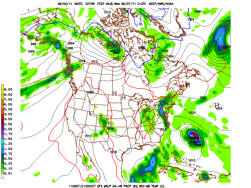
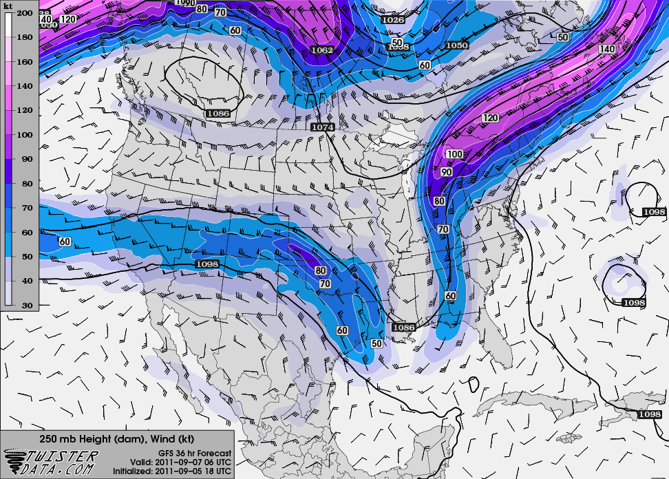
A potent upper level low is digging and progressing east-southeast at the moment over the midwest.  We have seen a nice drop in temperatures over the past few hours as the cold front that is currently draped over west-central KY has passed through.  Post-frontal rain showers have formed ahead of the upper level trough over eastern Missouri and will progress east-southeast towards the area.  Rain showers could start overnight but looks to begin after morning commute but may have to deal with patchy fog that may form under clear skies tonight.  Rain should exit the area by midday or early afternoon.  Also, the upper level low will continue to spin and become cut-off from the main flow overnight tonight bringing around a shortwave on the backside of the upper low that will bring the showers into the area tomorrow morning.  Skies should stay partly cloudy rest of the day today with a high around 71 and an overnight low around 50.  Clouds will start to roll in during the early morning hours.  The two figures below show the evolution of the cut-off low from this morning to midnight tonight, respectively.

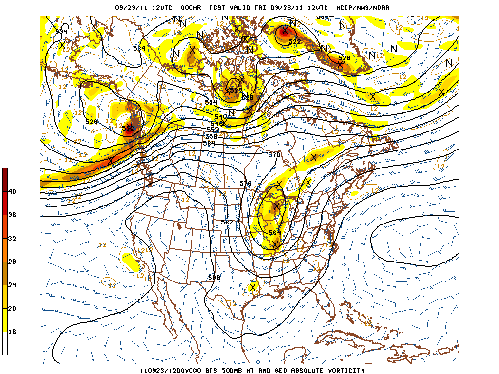
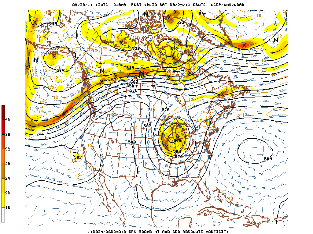
GFS and NAM both show a halt in the progression of the 500 hPA cut-off low over northern Illinois. NAM actually has the cut-off low retrograding westward over northeastern Missouri, whereas GFS has is staying over northern Illinois.  Regardless, we will be impacted with showers throughout the weekend due to shortwaves transversing around the cut-off low. Saturday evening through Monday morning the Ohio River Valley could see on the higher end of one inch of precipitation in a few areas. However, expect most areas to be around a half inch during this period.  Highs will not fluctuate much and will tend to stay around the 70 degree mark with lows in the low 50s.  Does look like at the beginning of the work week we will start to see a drying, warming trend.

Friday: Partly Cloudy, with high 71 and low 50. North winds around 6 mph.

Saturday: 40% chance showers , mainly after mid-morning. High 71 and low 53. Wind becoming south at 5 mph.

Sunday: 50% chance showers with high 73 and low 53.  South winds at 5 mph.

Posted in Kentucky Weather | Comments Off on Cool, wet start to Fall

Two systems to impact first half of work week

Highlights

-Rain to start work week

– Temperatures will gradually decrease throughout the week from upper 70s to low 70s

– Atmosphere revamps for another round of possibly strong T’storms Wednesday evening

A neutrally tilted shortwave trough axis extending from Minnesota to Missouri is ejecting eastward towards our region.  As it does so, moisture is building into the area off southerly winds ahead of this system.  Showers will impact much of the Ohio River Valley  overnight tonight and continue throughout the day ending late Monday.  The cold front associated with this first system is rather weak, but still expect to receive a half  to three-quarters of an inch of precipitation.  The 500 hPa map below shows the shortwave that will impact our weather at the start of the week.

Clouds will diminish overnight Monday giving way to partly cloudy skies on Tuesday with a high of 79 and an overnight low of 63.  However, winds will be persistent from the south around 8-12 knots bringing in moisture from the Gulf. That said, clouds will be increasing during the afternoon on Tuesday as showers from the next system will reach our area early Wednesday morning.  There is instability for the next system to tap into bringing chances for scattered strong thunderstorms.  However, since there is a lack in deep moisture, it will keep severe storms to a minimum (Skew-T below). There is sufficient enough shear to structure a squall line that will encompass much of the Ohio River valley. Wednesday evening.  If a strong storm does form in the area, the storm will be limited to small hail and damaging straight line winds.  A 500 hPa map below shows the system that will impact the region Wednesday into Thursday.

The front will move slowly east of us on Thursday with chances diminishing on Thursday as the day goes on.  Friday through Sunday looks to be great with highs only reaching into the lower 70s and lows in the lowers 50s under sunny skies.

Monday: Showers/T’storms likely throughout the day into the overnight hours.  High around 75 and low around 64 and south winds persistent at 8-12 knots.  Expect half inch of precipitation.

Tuesday:  Partly cloudy skies with a high around 79 and a low around 64.  Slight chance of showers late Tuesday night.

Wednesday: 50% chance of Showers/T’strorms later in the afternoon with a high around 78 and a low around 60.  Some strongs could be severe with small hail and damaging winds.

Posted in Kentucky Weather | Comments Off on Two systems to impact first half of work week

Another beautiful weekend in store

After a welcome dose of rainfall and cooler temperatures this past week, a ridge of high pressure will build into the Bowling Green region this weekend. This means that picture-perfect weather will be the rule. Highs are expected to be in the upper 60s once again today, with temperatures warming into the mid 70s under mostly sunny skies on Saturday and into the low 80s on Sunday. Overnight lows will be on the cool side this weekend, with lows in the low 50s expected tonight and upper 50s tomorrow night.

Our next shot at rainfall will begin late Sunday, with off and on chances of precipitation early next week as a stationary front meanders around the area. Until then, get outside and enjoy the nice weather!

Posted in Kentucky Weather | Comments Off on Another beautiful weekend in store

Rain and cooler weather still on the way

Rain, possibly with a few embedded thunderstorms, will overspread the Bowling Green area tonight ahead of an approaching cold front.

As the picture above shows, southern Kentucky is expected to receive around a half to three quarters of an inch of precipitation. Behind the frontal boundary, temperatures will fall below average. Highs in the upper 60s and lows in the upper 40s are expected tomorrow and Friday. More seasonable temperatures are expected for the weekend and into early next week, with highs climbing back into the upper 70s and lower 80s.

Posted in Kentucky Weather | Comments Off on Rain and cooler weather still on the way

Midweek rain chances followed by a cooldown

After a warm and dry start to the week, a cold front will push through the region in the Wednesday night – Thursday timeframe. This system will bring a good shot at some rainfall and usher in fall-like temperatures for the weekend.

Highs tomorrow are expected to top out in the upper 80s, with temperatures in the lower 80s on Wednesday. As the graphic above shows, the frontal system is expected to drop up to a quarter inch of rainfall in the Bowling Green area Wednesday night and Thursday. Highs Thursday are only expected to reach the upper 60s.

Posted in Kentucky Weather | Comments Off on Midweek rain chances followed by a cooldown

Great Weekend Weather

Hightlights

Warming trend through the weekend

Partly sunny with a small chance of rain

Forecast

The weekend weather is shaping up to be a nice one! The cut-off low that has been dominating our weather this week with cloudy skies and drizzle, is finally opening up into a longwave and translating downstream.

Under suface high pressure and southwesterly flow, highs will reach 80 on Saturday and sunday under partly cloudly skies. This warming trend will continue into next week with more seasonably temperatures into the mid- 80’s. Another update will come soon, but in the mentime, enjoy this nice weekend!

Posted in Kentucky Weather | Comments Off on Great Weekend Weather

Dreary Weather Continues….

Highlights

Upper level low continues to hang over the mid south bringing cool temps and rain chances for the rest of the week.

Precipitation should become more scattered in nature tomorrow evening through the rest of the work week.

I love the rain, its much needed and not bad news to me, but if you like sunshine you may have to wait awhile. The pesky cut off upper level low, will continue to remain quasi-stationary into the immediate future. However as the surface remanants of Lee slide slowly north, precip should become more scattered in nature instead of wide spread rains. Speaking of rain, pictured below is rainfall totals from this morning from the NWS. They are likely higher from today’s rainfall.

So no change as of yet. Temps will not break 70 again tomorrow as clouds and rain still dominate the weather. Tomorrow’s high looks to be  68.

Posted in Kentucky Weather | Comments Off on Dreary Weather Continues….

Welcome back students and avid blog readers alike!


As classes return at WKU, so does our blog, with Meteorology/Geography students actively blogging at least three times a week. The blog will return to its native format such as from spring semester, where students will post on current weather, as well as forecasts, and any other pertinent news relating to Meteorology.

That being said, how about this weather?

We’ve witnessed a major pattern change away from our dry oppressive heat to cool,wet weather thanks in part to two key players; an upper level trough and its resultant surface cold front, and the remnants of TS Lee.


Pictured above is the winds at 250mb (jet stream winds) which show the deep, fall-like trough axis that will be dominating our weather for the near term. This combined with plentiful moisture from Lee will keep temperatures in the 70’s all week with rain chances nearly every day as Lee’s surface low gets nearly “cut-off” from the upper level flow. Tues temps in BG will struggle to hit 70 on Tues. with a good chance of rain! Grab a hoodie, and in the mean time, more to come…

Posted in Kentucky Weather | Comments Off on Welcome back students and avid blog readers alike!

Field Methods-Day 14

By: Lindsay Rice

We left Hannibal, MO around 8am on Wednesday morning. The group reflected on the trip for a majority of the way home. We reminisced about the experience and shared pictures and videos. We dropped Dr. Dixon off in Memphis, TN then made our way back to Bowling Green, where we cleaned the van. Everyone agreed that the trip was a great experience that we will remember for the rest of our lives. We have gained knowledge outside of the classroom that has helped us apply what we have learned in class to real life situations. This experience was unlike any other class we had ever taken, and everyone would agree to do it again in a heartbeat.

Posted in Kentucky Weather | Comments Off on Field Methods-Day 14

Field Methods – Day 12

Posted by: Kate Wilson

Today seemed like the last promising chase day of the trip. The setup involved a surface low in the northern central plains, with a warm front situated west to east across the Midwest and a cold front stretching from South Dakota through Colorado. Southerly flow off the Gulf of Mexico brought up moist air with dewpoints in the upper 60s and lower 70s. The surface showed clearing in southeastern South Dakota and eastern Nebraska. CAPE values were expected to exceed 5000 J/kg, but a strong cap was in place as well. However, it looked like a break in the cap would drape from central Nebraska up to eastern South Dakota. While the strong CAPE seemed able to break any remaining cold cap by late afternoon, the main issue with the setup was wind sheer. Winds aloft were very weekly veering, and there were low helicity values, meaning smaller chances of powerfully rotating supercells and thus tornados. Looking for a break in the cap, some students set their sights as far north as Sioux Falls, but we decided to remain in Nebraska and head towards the town of Taylor in the central part of the state.

Throughout the day, a mesoscale discussion was issued by the Storm Prediction Center which described the situation we were anticipating: large amounts of instability with a good chance of strong thunderstorms, which would likely start as discrete (individual) cells, becoming a joined line of storms with time. This was due to the mainly unidirectional vertical wind field. It was key to be on a storm as soon as it formed for its best chances of rotation before congealing into a line of other storms.

Storms began firing around 1900 UTC to the southwest and north of Taylor. We decided to pursue a storm to the north which produced wall clouds and several gustnados, one of which was mistakenly reported as a tornado by another storm chaser. This is somewhat easy to do as a gustnado is a circulation visible as a dust whirl on the ground due to turbulence from the main storm. However, there is no upper level support in the form of a rotating updraft or wall cloud, so this cannot be classified as a tornado, although they may mimic one in appearance. Eventually this cell became more organized and had a well-defined circulation, but we had to abandon it when it started right-turning and the limited road access prevented our chase.

We then watched cells fire on the tail end of the quasi-linear convective system. This term simply describes a “line” of storms that is not definitely linear joining together multiple cells displaying linear characteristics. After watching the new storms form, we made the decision to move northward towards O’Neil to get a better view of more mature, possibly right-turning storms. A cell that begins to turn to the right of the mean wind flow is usually a good indicator of imminent rotation and tornadogenesis. This is due to the increase in helicity and wind sheer from the motion of the storm in the shifting wind field. We were satisfied with our choice to go north as the storms to our south were bowing out and overall becoming more linear. This linearity shows that a storm probably only has one strong burst of wind in a unified direction, and as it bows may also produce damaging straight-line winds. A tornado was reported on our way to O’Neil, and by the time we arrived, the entire complex of storms had become substantially more linear. There were brief episodes of rotation indicated on reflectivity, but as the sun set, we decided to end our chase. The team headed to Norfolk, Nebraska, awaiting the conclusion of our trip in the coming days.

Posted in Kentucky Weather | Comments Off on Field Methods – Day 12