Winter Wx Advisory tonight for South Central Kentucky

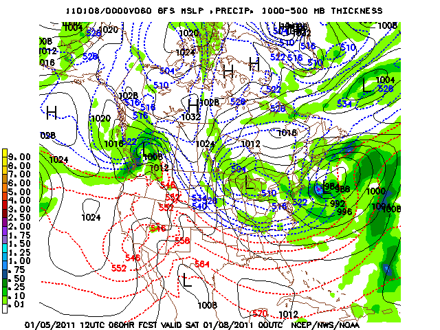
Following this weekends cool blast and a more active southern stream, A significant winter storm will impact the deep south tonight through Tuesday. However, for our neck of the woods, most of the heavy accumulations will remain down south.
cu
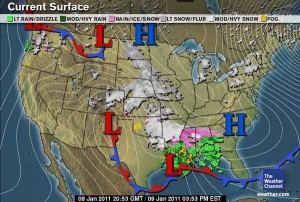
A deep 500 mb trough in place through the central U.S, with an embedded shortwave trough with translate northeast across the south over the next 24-46 hours. The resulting surface low pressure cylcone will track along the gulf coast, where Warm air advection and a strong low level jet will advect ample moisture in the deep south.

This is a classic overrunning situation where southernly winds in front of a system ‘overrun’ with respect to density and height, cold air that is already in place at the surface. Places such as TN where there is a sufficently deep cold air mass in place will remain all snow, where as the deep south will experience a wintery mix with heavy ice accumulations a particular concern for Alabama.

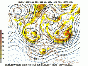
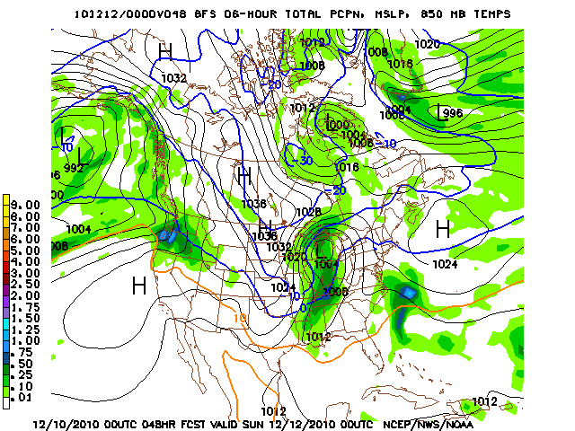
The graphics below depict the 850 mb temperatures and the forecasted precipitation for 6 am central time tommorow.

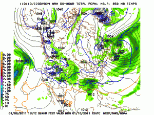
The NAM(top) is slightly more aggressive in bringing in more moisture than the GFS(bottom). However both models as well as other model suites are in good agreement on the track of the surface low. The important thing to note is the sharp forecasted precipitation gradient as moisture tends to fall off very quickly north of say Nashville. As far as snow totals are concerned in South Central Kentucky; anywhere from a dusting in central Kentucky to 2 in of snow along the KY/TN border are possible.

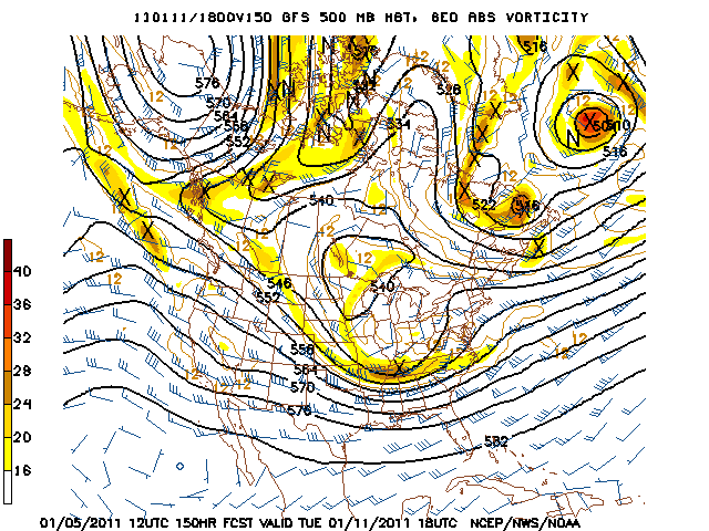
For snow lovers, another chance of accumulating snow is forecated for Tuesday morning as an upper-level wave and its surface reflection pass through our region. So make sure and stay tuned for updates.

Even further out things look to get brrrrrr. cold as an truly artic airmass may make it as far south as kentucky next weekend. Should be an exciting week for weather!

Posted in Kentucky Weather | Comments Off on Winter Wx Advisory tonight for South Central Kentucky

Chance of Light Snow Friday

A system to our south is bringing some snow south of the KY/TN line, but north of the state line could see some snow flurries through mid morning to early afternoon. No snow accumulation is expected in central and south central Kentucky. Middle Tennessee could see a trace to an inch by the end of the day.
curwx_600x405
Thursday we clear the skies for a short period in advance of another system that will impact our area during the day Friday. A clipper system will swing south out of Canada into the Great Lakes and as it does so will produce some snow showers in response to an upper level shortwave that will swing over the region. Anywhere from a trace to less than one inch of snow is expected for this event. The main story is that we will remain bitterly cold through the next few days as we remain in northwest flow aloft.gfs_slp_060s

Models the past couple days were banging heads on a system that looks to hit the region Sunday night through Monday night. The system the past couple days were bringing accumulating snow to the area, however the European model and GFS model have now started to agree on a more southerly track. A surface low is forecast to swing over southern Louisiana Sunday evening and could produce some light snow showers in middle Tennessee but not accumulating to anything. Overnight Monday night, a lagging upper level low looks to swing into the area which could bring some snow showers to central Kentucky. Still though, little to no accumulation is expected at the moment.gfs_500_150s

Wednesday: Hi 36 Lo 26. Scattered flurries early then changing to light rain. East wind at 5 mph.

Thursday: Hi 41 Lo 26. Partly cloudy for most of the day, then becoming mostly cloudy with a slight chance of light snow after midnight.

Friday: Hi 31 Lo 19. 30% chance of light snow. Trace to less than 1 inch expected. West wind 5-10 mph.

Saturday: Hi 32 Lo 21. Partly sunny skies.

Southern Christian County had a report of around 0.10″ of snow on the ground, if you have any reports feel free to comment on the post to let us know!

Posted in Kentucky Weather | Comments Off on Chance of Light Snow Friday

Chilly temperatures will stick around…

A high pressure is building in over the area as we head into the evening hours and quickly moves out of the region by tomorrow afternoon.  There is a slight chance of flurries/sprinkles Wednesday afternoon into the evening, however best chances are south of us near the Nashville area.  The system will clear out in advance of another system impacting our area Thursday night through Friday morning.  A clipper system will track north of us, models are pushing some light precipitation our way in the form of light snow or flurries.  Models are only pushing around a couple hundredths of an inch into the area, GFS has around a tenth of an inch, anywhere from a trace to an inch is possible at the moment.

The start of next week is looking interesting, but to even mention a forecast for that would be ridiculous since it is so far out.  However they do show some snow accumulation as a possibility.  The next forecast by Kyle coming at the first of next week will hit on this more.

Tuesday:  Expect mostly clear skies with highs in the low 40s and lows around 20.  West wind between 5 and 10 mph.

Wednesday:  Expect mostly sunny skies to start, with clouds rolling in later in the day as we have a slight 20% chance or flurries/sprinkles in the afternoon.  Highs will be in low 40s with lows in the upper 20s.  West wind between 5 and 10 mph.

Thursday: Partly cloudy skies to start but expect mostly cloudy skies by the evening hours as our best chance of flurries arrives overnight into early Friday morning.  30% chance of snow. A trace to one inch possible.

Friday:  Expect partly cloudy skies with highs in the mid 30s and lows around 20.

The long range forecast seems to keep the cold temperatures around for a while, so keep those jackets and coats handy.

Posted in Kentucky Weather | Comments Off on Chilly temperatures will stick around…

9:00 pm update

The main Heavy snow band tonight has tracked further south than
expected thus another holiday update. Snowfall rates have been up to
an inch and hour within this period of heavy snow with reported totals
of 1-1.5 inches from the NWS. The heavy snow should continue till
around 10 pm with light snow showers through the remainder of the
weekend. With the heavier snow band going further south than expected
totals should be around 2-4 inches through Sunday night. Roads will be
snowcovered due to the heavy rate of snowfall.

Lead forecaster: MWG

Posted in Kentucky Weather | Comments Off on 9:00 pm update

11:00 am update

Temperatures have gone at or slightly above freezing this morning. Precipitation is moving in from the Missouri valley and should arrive in the region late this afternoon. With the temperatures near freezing and faster timing of the system this precipitation may begin as a mix of rain or sleet before changing quickly to snow. Periods of light snow are expected through Saturday with around an inch by Christmas night. Numerous snow showers are still expected Sunday due to an upper level low producing additional accumulations for a weekend total still from 1 to 3 inches. This will be the only weather statement this weekend due to the Christmas holiday unless there is a drastic change in expected conditions. Happy holidays once again.

Lead Forecaster: MWG

Posted in Kentucky Weather | Comments Off on 11:00 am update

white christmas likely but not certain this year

Over the past few days modeling has been going back and forth on a phased or unphased storm for Saturday. If the storm is unphased the snow will be more disorganized and lighter across the region, if the storm were to phase then a larger heavier area of snow would occur with a track further north. In terms of accumlations this would make the difference from an inch or so or a storm that would bring more than 4 inches However now there is more confidence now that a less phased solution will occur. Take a look at the 500 mb maps for the recent 12z run and older 00z run for today.

the 12z run is back to being less phased with the storm

the 00z at the same time Saturday morning has already merged/ phased the energy from the southern and northern systems.

with the energy and upward motion needed for low pressure development in two separate regions a more disorganized system is  likely. Two areas of precipitation will move from west to east across the region. One more focused from Iowa into the lower Ohio valley Friday night into Christmas day. The other associated with the southern feature moving over the Tennessee valley and deep south. Right now qpf appears to be around or just over .1 from Friday afternoon into Saturday with the steadiest snow falling late Friday night and Saturday morning. This will likely create some travel issued around the region and i expect a winter weather advisory to be issued sometime Friday. Behind the system the wind off the great lakes is favorable for additional snow showers through Sunday with more light accumulations. This brings storm totals to 1-3 inches by Sunday afternoon. Let’s take a look at our storm a very good track but unphased and disorganized. If the storm was more phased a snowfall over 4 inches would have occurred, this outcome looks highly unlikely.  there is also an outside chance precipitation starts as rain but all snow is expected at this time.

GFS

Christmas eve

christmas morning

Sunday night

NAM

Christmas eve

christmas morning

sunday afternoon

highs will be in the mid 30’s Friday. Light snow is expected for Friday night Through Saturday with snow showers into Sunday. lows will be in the 20’s Christmas morning with highs near 30 Saturday. Temperature Sunday will be in the 20’s with the snow showers.

For an offical white christmas an inch of snow needs to be on the ground sometime christmas day. Right now the odds are very good off seeing an inch of snow christmas day but with thie disorginzed nature of the storm there is a chance Bowlign green sees one badn of light snow and one to the south. my white-o-meter indicates a white chirstmas as snow falling anytime during the day or any accumlation on the ground. The offical defintion is more strict.

white-o-meter: 9.99/10 ( don’t want a jinx)

chance of official white Christmas 9/10

happy holidays to all!!!!  No more updates will be issued on this storm unless there is a signficant change in forecast thinking.

Posted in Kentucky Weather | 1 Comment

Will 2010 be a white christmas???

That is the question on the minds of many kids awaiting Christmas morning. A white christmas always adds a little extra for the holiday season and the pressure is on meteorologists to provide. Annually snowfall is only about 10 inches in Bowling green for the official white Christmas an inch of snow needs to be on the ground Christmas day, odds are usually slim around 10%. However this year are odds are much greater. We continue to be a pattern dominated by the  – AO which is more of a short term teleconnection which offsets the expected warm and mild winter that is typical from la-ninas, thus one month in the winter forecast is a bust. Let’s lay the groundwork for the Christmas weather.

We’ll have reinforcing colder air streaming into the region Thursday with low pressure moving into the southern Rockies. This reinforcing shot of cold air will keep highs only in the 30’s.  After a clouds and drizzle/ flurries Wednesday, Thursday should see some sun.

Christmas eve the low pressure moves out into the plains with one piece going north the other staying south. At this time is the key to our white Christmas chances . Does the southern energy move slower into the plains and dig back this would mean a later phasing and storm development to our east, the ECMWF has been pretty steady on this. Or does the energy phase faster near the Tennessee valley which is what the gfs has also being steady with this solution. The stronger GFS solution would yield snow perhaps starting out quickly as rain Christmas Eve afternoon then quickly changing to snow for Christmas eve into day with several inches of snow. The ECMWF would yield some light snows for Christmas eve and day with a lighter accumulations.

white-o-meter for a white Christmas for Bowling Green

White-o-meter: 9/10

even the drier ECMWF has an inch by days end. Arctic air will follow behind the storm.  There should be a higher forecast confidence as this system enters the upper air network tomorrow. An official forecast will be posted sometime late Wednesday night or Thursday. Be advised travel for Christmas eve and Christmas day will likely be impacted by snow.

Posted in Kentucky Weather | Comments Off on Will 2010 be a white christmas???

Weak system to bring light rain

Highlights

*Highs in the low to mid 40s
*Light rain Monday night/Tuesday
*High pressure dominates mid week

A system to our north will bring rain to the area Monday night into the afternoon on Tuesday.  Cold air will remain to the north of us, snow is not expected.  Temperatures will be well above freezing during the day and nighttime hours.  Highs Monday are expected to be in the mid 40s and overnight lows in the mid 30s.  Tuesday highs are expected to reach into the mid 40s as well with rainfall amounts between one tenth and two tenths of an inch possible during the day, lows will dip back into the mid 30s overnight Tuesday into Wednesday.  Expect highs on Wednesday to be around 40, with lows in the mid 20s.  High pressure will build its way into the region on Wednesday and dominate the weather ahead of another system for holiday weekend, which could bring us a white Christmas! No severe weather expected this forecast period but stay tuned for weekend storm, as we will have updates as we know travel is a major concern.

Posted in Kentucky Weather | Comments Off on Weak system to bring light rain

Weekend Storm

Boy what a difference a few days makes. Latest model runs now provide quite a drastic picture shaping up for this weekends weather. Both the European and GFS as Well As The North American Mesoscale Model, are in pretty good agreement of a more northerly storm track. Confidence has grown in the Model solutions as the system is now in the United States upper air network.
In General the system has taken a more northerly track with a surface cyclogenesis developing in the plains today, and the low moving northeast into the great lakes. Saturday looks to be all rain, and alot of it, as most areas should pick up anywhere from .5 to 1 inch of rain with embedded elevated instability. So, a rumble of thunder, especially into TN can not be ruled out. In the wee hours of the morning as the cold front pushes through, rain should change to snow from west to east as the front pushes through, expect only minor accumulations before dry slotting quickly cause a cease in snow. During the day on Sunday however, snow showers and flurries will be on the increase as wrap around precipitation in the northwesterly flow will cause a fetch of moisture to come off of lake michigan providing Bowling Green with some flurries and the bluegrass region of KY with some minor accumulations.

Here is an image from the 12z model run of the GFS illustrating this.
geefus

All in all, it will turn drastically cooler on Sunday and Monday with highs in the mid-20s on Sunday and lower 20s on Monday. Overnight lows those nights will also struggle to get into the teens as artic air infiltrates the area.
For Saturday expect up to one inch of rain in Bowling Green with a high of around 50, and after the front moves through Bowling Green should pick up one inch of snow or less, while areas to the northeast should recieve more, with maximum amounts in the blugrass region of ky of around three inches.

Posted in Kentucky Weather | Comments Off on Weekend Storm

Clipper System Lookout and VERY Cold Air Behind

As mentioned in previous blogs, a clipper system will be advancing from the NW and swinging south into the SE.  Tracks were unknown as of a few days ago, however, models now are now in better  agreeance of a more southerly track which will make our weather here in the mid-south very interesting.  GFS seems to be the model of choice as it kind of splits the other forecast models. Overtime as models come out with new runs, this following forecast could drastically change, as we are still 3-4 days out.

A strong 300 hPa jet stream maxima will be digging on the descending side of the upper trough which will help to deepen the trough bringing with it cold arctic air.  A 500 hPA trough deepens in response and produces a vorticity maxima that over time swings from the central plains into the Arklatex region and then south of Nashville late Saturday night into Sunday.  GFS is pushing a closed 850 hPa low right over Kentucky, along with a surface low through Tennessee.  Now what you generally want for a snow storm is an 850 low to track south of Nashville along with a surface low in central Alabama to allow for moisture to be isentropically lifted over the warm front where overrunning of precipitation occurs.  That over running precipitation wraps around the circulation on the cold side of the low falling in the form of frozen precipitation.

So since the track is directly over us, as of now expect Saturday to be strictly rain with temperatures warming into the upper 40’s.  Strong warm air advection is taking place ahead of it allowing for a warm up and rain to be the main source of precipitation.  Anywhere from three-quarters to and inch of liquid precipitation is likely during Saturday.  As the low tracks ENE the area will begin to get dry-slotted from west to east with respect to time which will allow for cold air to build into these areas.  Wrap around moisture will then fall as frozen precipitation and anywhere from 1-3 inches could fall.  It seems Saturday night into early Sunday morning is when things could switch over.

gfs_slp_096s1
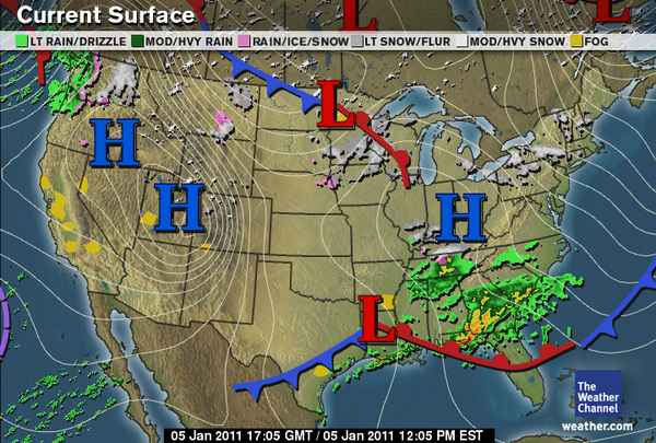
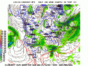
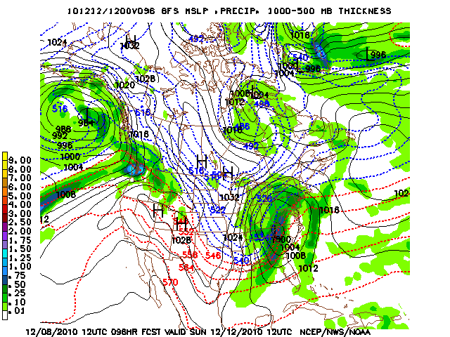
This model image is valid for Sunday 12 UTC taken from the 12 UTC GFS run.  This time is roughly 7 a.m. on Sunday morning.  You can see warm air advected in front of the low and cold air diving south on the backside.

Please keep in mind that any shift in the track of the low will drastically change the forecast. If the low tracks further north than noted in this discussion, that would entail more rain and minimal snow accumulations if any at all.  Most clipper systems such as this one more times then not tend to keep further north, so it will be interesting to see if this does the same.  Or if it tracks further south, precipitation would fall more on the frozen side with snow instead of rain.

We will continue to keep you posted in this situation, as time nears the confidence in the forecast will become stronger.  For now listen to your local weather authorities for their forecast as well.

Secondly, as this storm passes over the weekend very cold arctic air much like this weeks will advect into the region.  Highs on Monday might not even get much above the low 20’s and lows Monday night will fall into the single digits it seems.  One thing is for certain, cold air will be prevalent at the start of the week.  If snow is on the ground, that will make for much colder temperatures.

Posted in Kentucky Weather | Comments Off on Clipper System Lookout and VERY Cold Air Behind