Surprise Rain Wednesday, Warmer Weather Next Week

On Wednesday, an overachieving storm system brought a surprise dose of rainfall to the Bowling Green area. This precipitation was associated with an upper level low and frontal boundary over the Gulf states that pumped overrunning moisture into our region, and it was not anticipated well by the models. The Mesonet station at the WKU farm measured a total of 0.35 inches of precipitation from 6:00 AM to 7:30 PM Wednesday with this event, while the NWS observing station at the airport measured 0.32 inches.

Currently, the entire eastern half of the U.S. is under the influence of a deep upper-level trough that reaches all the way down into the Gulf of Mexico. A ripple of shortwave energy embedded in this trough brought us a few light showers this morning. Over the next few days, the trough should slowly progress to the east, with an upper-level ridge moving in to take its place. This will lead to moderating temperatures, with highs near 70 expected by Monday and Tuesday.

12znam20101105current
Current 250 mb heights and wind, showing the highly meridional flow across the U.S.

Posted in Kentucky Weather | Comments Off on Surprise Rain Wednesday, Warmer Weather Next Week

Cooler Weather Continues

With the current jet stream pattern the way it is and the expected evolution of the jet stream as projected by the NAM and GFS, cooler temperatures can be expected throughout the week, with a more winter like feel to the weather as we head toward the weekend where highs might even struggle to reach the 50s.  The expected evolution of the pattern at 250mb is for a continued high amplitude meridional pattern with a trough digging very deep over the Midwest and producing a cutoff upper level system that will progress into the Gulf of Mexico by mid week and be picked back up by the main flow heading toward the end of the week. What does that mean for us?

Continue reading

Posted in Kentucky Weather | Comments Off on Cooler Weather Continues

Mild weekend …cool nights.

This weekend should be excellent weather for fall festivities. The surface high pressure that was responsible for many of SE KY’s freezing temperatures has translated east toward the carolinas, and return flow out of the south has allowed for some warm air advection and moderating temperatures. Temperatures should top out in the lower 60’s while dipping i8n to the upper 30’s at night. So, enjoy your fall activities, and have a safe and happy Halloween.

Posted in Kentucky Weather | Comments Off on Mild weekend …cool nights.

Hard freeze tonight?

Today should be a nice fall day, with weak cold air advection still taking place from yesterdays frontal passage. Temperatures today should see a high of 59 with light winds out of the WNW topping out about 7 mph. Tonight, however, things will really begin to cool off as surface high pressure dominates the area. The cumberland river area has the best chance of a hard freeze as they will be under the high pressure maximum at sunrise, and radiational cooling will be maximized. For Bowling Green, expect widespread frost under light to no winds tonight,with a low of 32. Again, frost and possible freezes are possible in the more prone sheltered and low lying areas.

Posted in Kentucky Weather | Comments Off on Hard freeze tonight?

It may very well be fall…

Sunny skies are deceiving as temperatures have begun to fall in Southern KY. A reinforcing shot off cold air from Tuesday system has arrived in the form of a cold front as Cold air advection is currently taking place. It will be wind with winds 10-15mph, and continuing to get colder as today’s maximum temperature has already been reached today.
For tonight, frost is once again possible as temperatures fall, the skies clear, and high pressure settles in. Most areas will approach freezing with Bowling Green specifically reaching 33 under light winds. Otherwise any other low lying areas or sheltered areas are prone for a patchy frost. Otherwise the rest of the week seems climatologically seasonal, or just a tad bit cooler. More to come..

Posted in Kentucky Weather | Comments Off on It may very well be fall…

Severe Weather Update for Tuesday

Tomorrow there is a good chance that the storms rolling through around midday will be severe, straight line wind damages will be the main threat as winds will be sustained at around 20 mph.  Gusts could be over 40 mph.  Winds will pick up overnight and by early morning hours we will see the effects of the tight pressure gradient and the approaching cold front.  The cold front will be through the area by 3:00-4:00 pm. But expect the heaviest winds ahead of the cold front.  An embedded tornado can’t be ruled out though, tornadic supercells will be favorable near the southern end of the squall line.  So depending on how far the squall line reaches southward, that southern tip will be favorable for tornadoes.  In the main line, the main threat is straight line winds.

day2otlk_1730

Otherwise expect a high temperature around 75 and a low around 50.  Winds being the main factor starting overnight tonight.  Keep an outlook on weather throughout the day.  If frontal timing is later, that will give the atmosphere more time to heat up and destabilize which could up the severe potential.  If that is the case, an update will be posted as soon as it becomes eminent.

Wednesday we will be under mostly sunny skies with a high in the mid to upper 70s.  Still on the windy side with winds ranging from 7-13 mph and gusts over 20 mph.  A low Wednesday night around 45.  Winds calming down Wednesday night as well.

Posted in Kentucky Weather | Comments Off on Severe Weather Update for Tuesday

Historic Storm? Rainy next couple of days…

An upper level tough exists over the region and will allow for some convection to our west through the morning hours, allowing for rain chances before noon.  However most of the heavy precipitation has pushed its way on out of the area.  Highs today will reach near 80, which is not normal for late October.  Tonight temps will stay unseasonably warm as well as we remain in the warm sector of system to our north.  A cold front will approach early Tuesday morning with a few scattered showers out ahead of the front.  However, Tuesday is when things get real interesting.

Tuesday and Wednesday are setting up to be historic.  Maybe not for this area in particular but definitely for the northern Plains and the Great Lakes region.  A low is forming off the Rocky Mountains and is forecast to move northeast into Minnesota.  As it does so, will deepen to around 964 millibars, which is not typical in the U.S. at all.  A strong pressure gradient will exist through most of the eastern U.S., including our area.  Winds expected to be high today through Tuesday afternoon.  Stronger winds on Tuesday around 15 to 22 mph with gusts in the mid 30’s or higher.  Dynamics with this storm will be enough to suggest a strong line of storms rolling through the area Tuesday mid morning through Tuesday night.  A few embedded tornadoes can’t be ruled out from the strong line of storms to roll through Tuesday.  Rainfall amounts Tuesday through Wednesday are expected to be between 1 to 2 inches.  An update will come shortly as we gain more knowledge of what is to come.  Here is the look at NAM model output for Tuesday.

nam_slp_036s

Posted in Kentucky Weather | Comments Off on Historic Storm? Rainy next couple of days…

Winter forecast 10-11

He is my winter forecast for 2010-2011. the regular rotation of daily forecasts will return Monday.

First let’s start with an overview of recent events we have very warm and dry weather in recent months as a transition of an el-nino to la-nina is in progress. Sea surface temperatures (SST’s)in the tropical pacific have already reached -1.5*C in some spots.

NOAA

Tropical Pacific Sea Surface Temperature Anomalies Animation

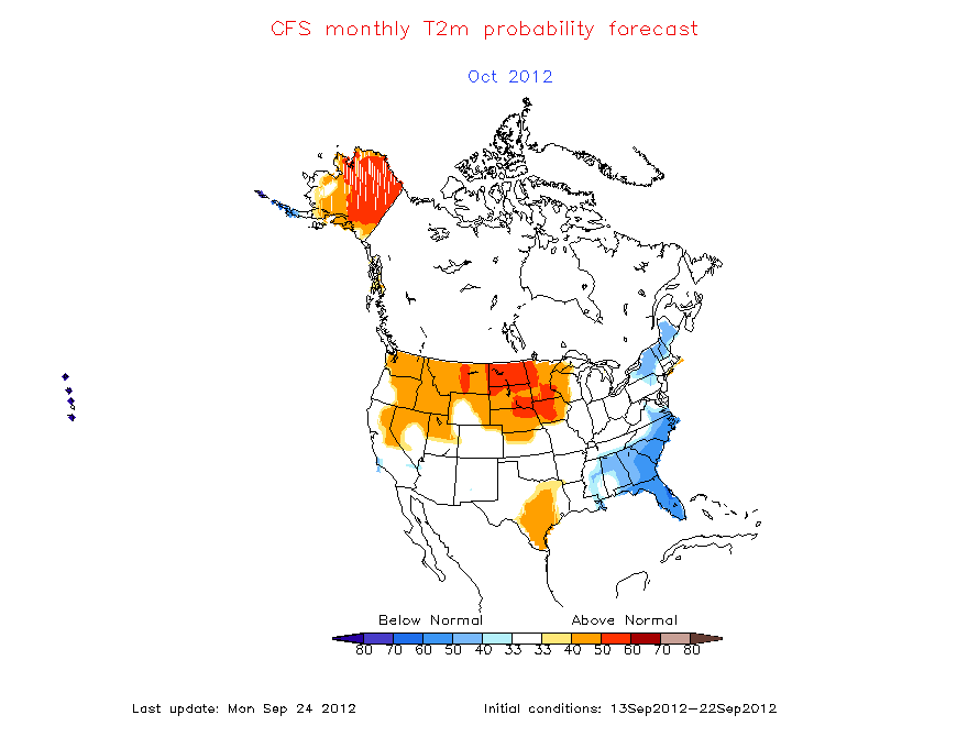
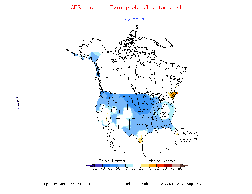
over the next few weeks long range modeling in the 10-14 day period and teleconnections indices suggest a mean pattern of an eastern trough with a ridge in the west carrying us through oct.  This october/november expected pattern is a factor being considered in my winter forecast. The CFS is also calling for a cold fall for the region.

CFS

Next we add in a major component to the winter forecast is Sea surface temps in the pacific currently the anomalies are already suggesting that a la-nina is in progress and if the strength of the cold anomalies hold in the tropical pacific then this la-nina could become strong. Model projections of the la-nina progress it to at least a moderate status if not strong ( -1.5*C) for several months.

NOAA model projections for the nino state from there weekly report

most of the modeling projects a moderate to strong la-nina this winter.

So from looking at what has happened the past several months and what is expected to happen in the next few months with  the SST”S we have several comparison winters known as analogs to look at

2007-2008

1998-1999

1988-1989

1973-1974

The first thing that should jump out is that 2008 featured the infamous super Tuesday february severe outbreak. all of these winters had an el-nino which had already gone to la-nina which became moderate to strong by the wintertime.  the winter of 07-08 featured many back and forth temperature swings with snow in march and severe weather in February which was followed by several mixed precipitation events. The winter of 1998-99 was mild overall but did feature a snowstorm similar to 07-08. research also shows the winter 1988-89 was mild.

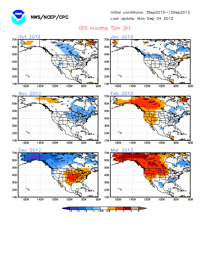
Another factor in the forecast is what the climate modeling is showing for the upcoming winter

CFS

ECMWF seasonal model approximate map ( I’ve seen the euro model forecast for the winter however it can’t be copied onto the site so here is a homemade map approximating what it has)

above normal temperatures for most of the eastern United States. Many of the climate models are going in this direction.

another contributor will be the switch to a cold PDO which will likely aid in the establishment of a western trough pattern during the winter

Now to the forecast

summary so far

– everything I’m seeing indicates a moderate to strong la-nina

– thinking a cooler pattern through november

– analogs of similar winters mainly mild with some snow and large temperature swings throughout the winter  

Forecast

Overall I’m expecting the la-nina to be the dominant player this winter. However the cooler pattern expected through November could make for some colder and snowier conditions than normal in december, it should also be noted that some past la-ninas have been known for a fast start to winter. By January a storm track from the west coast  into the plains and upper midwest with a ridge in the southeast will be in place ( very mild with thunderstorms for KY). However I don’t expect every storm to take this track with a secondary track through the Ohio valley ( light mixes/ mainly rain) and a few systems which take  third track from the southeast up the east side of the Appalachians ( snow/ice events).  Clippers should mainly be confined to the upper great lakes with the potential for nw flow in December to send a decent clipper our way with some upslope snows in east KY with early shots of arctic air in december .  On average with the storm track well to our northwest mild air will be pulled into the eastern United States with colder airmasses in the Rockies and pacific northwest with a trough in place most of the winter coupled with an eastern ridge.

Temperature forecast

Precipitation forecast

Snowfall forecast

storm track A ( main storm track 75% of lows)

storm track B 17% of systems

storm track C 8% of systems

For Kentucky:

In December expect a cool end to the fall to have some effect on the first month of meteorological winter with somewhat cooler than average conditions and a trough in place over the eastern US this may allow for light snow events mainly in the form of upper level disturbances and nw flow events. However there will be at least some signs of the main winter pattern with a week or two of the month featuring a trough in the west and ridge in the east with milder than normal conditions and a storm track well to our northwest. The potential will also exist for on these storms to track east of our region bringing a more significant snowfall.

temps: 1-2*F below normal

snowfall: slighty above normal

Janurary-March

The main winter pattern will be for a storm track across the west into upper midwest with southerly flow periods of unseasonable warmth are likely with brief cooldowns followed by a quick return to warmth. the storm track to our west will allow for plenty of moisture to come into the region with several heavy rain makers. However there will be a few systems (track b) which can have enough cold air to produce mixed precipitation for the region with an even smaller chance of the eastern track system for a more signficant snow/ ice event.

temps 3-5*F above normal

snowfall: below normal

Winter breakdown for Kentucky:

Temperatures: 1-3*F above normal

Snowfall: 40-80% of normal

–  more severe weather than usual, also chance for some icing events

Make sure to check back Monday for a discussion on a potential squall line Tuesday.

Posted in Kentucky Weather | Comments Off on Winter forecast 10-11

High pressure and fall colors make for a beautiful weekend.

High pressure has settled in for the weekend along much of the country, making this weekend a perfect weekend to go out and view the autumn colors. Both the GFS and the NAM are forecasting the development of a moderate amplitude trough over our area in the middle of next week, with the National Weather Service forecasting rain showers throughout much of Tuesday, with temperatures dropping into the mid 60s next week, making it feel like fall just as much as it looks it. Still, with the exception of some rainfall over central California, there is not much to speak about today.

Here is a photograph of some of the autumn foliage in Bowling Green in a backyard on Nutwood Street under this weekend’s sunny skies.
100_0568_2

Posted in Kentucky Weather | Comments Off on High pressure and fall colors make for a beautiful weekend.

The CONUS is quiet, for the time being.

Weather patterns across the country are fairly quiet for the moment. The shortwave trough moving out of the northwest has greatly decreased the amplitude of the ridge over the western US, helping to create a largely zonal flow pattern across the continent. Indeed, the only remaining storms of interest are dissipating: the Nor’easter affecting New England has now completely occluded, reducing precipitation to a few bands of scattered showers, and what used to be Hurricane Paula has now become nothing but a sheared apart area of weak convection between the Florida keys and Cuba.

Both the GFS and the NAM are forecasting a cut off low to pinch off from the jet-stream and build a ridge over the western half of the continent by the beginning of next week, as well as bring more rainy conditions to the southwest. Over the next week, this will likely help develop a fairly strong trough, which should bring cooler conditions, as well as a chance of rain in the middle of next week.

Posted in Kentucky Weather | Comments Off on The CONUS is quiet, for the time being.