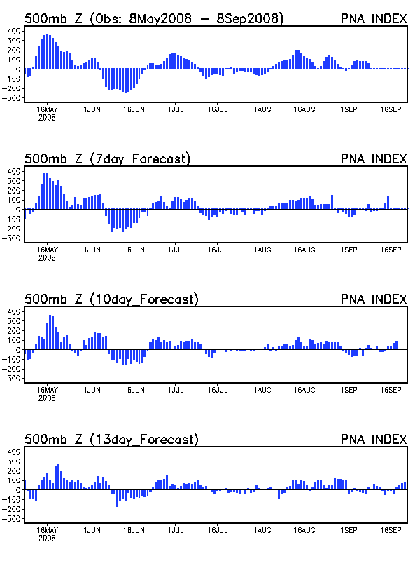
One small change in the value of a teleconnection is all that was needed to change our weather from cool and wet to hot and dry. This is a perfect example of why seasonal forecasting is so difficult. Continue reading
Blogroll
Login
Pages

One small change in the value of a teleconnection is all that was needed to change our weather from cool and wet to hot and dry. This is a perfect example of why seasonal forecasting is so difficult. Continue reading
June is almost here and Kentucky has yet to record a 90 degree day, although southern KY could get there on Friday (although I wouldn’t hold my breath). The median date for the first 90 degree day of the year is 6/2 for Bowling Green and 6/7 for Louisville. But more importantly, what does the rest of the summer look like? Continue reading
In my last post I discussed how a ridge would build across the central U.S. Thursday and Friday in response to a deepening trough over the western United States. As often happens this time of year, the downstream polar vortex that has brought the unseasonably chilly weather to much of the north-central U.S. over the past two weeks has become closed off aloft, which has resulted in an Omega blocking pattern that has delayed our warm-up. Continue reading
In my last post I mentioned that there was some model disagreement regarding the 2nd half of next week. I mentioned that the GFS called for a return to cold and wet while the European model kept the cold air to the west and allowed a warm ridge to overspread the central United States. Today’s GFS now agrees with the warm ridge idea. Continue reading
The phased jet streak pattern mentioned in my previous post that resulted in rain every 2-3 days will transition to a less wet but cool northwest flow over the next week. Continue reading
The rest of May is shaping up to be unsettled across the central United States as a perfect setup for shortwave generation in is place. Continue reading
The prolonged negative PNA pattern that has controlled the weather across the Mid-South since mid-March (right about the time I stopped posting) has kept things quiet and dry. That will change as a bowling-ball 500 mb low will barrel across the central Plains and bring some rain this weekend. Continue reading
The GFS and ECMWF have very different interpretations of Easter weekend weather. While the GFS shows a couple of minor shortwaves rotating around the trough, the ECMWF has a blizzard for New England. How can two models that use the same physics equations and initialize with same data come up with such wildly different results? Continue reading
Total snowfall accumulations at my house (6 miles east of Bowling Green) were 2.5″, with 2″ of that falling between 11 pm and 7 am this morning. Up to 4.5″ fell in western parts of Bowling Green where a nice convective band set up for several hours around midnight. Thus my forecast of 2-4″ total storm accumulations for Bowling Green with higher amounts in convective bands worked out well. The convective nature of the snowfall also illustrates why this type of storm is prone to major bust potential (ie., Paducah, Lexington). Continue reading
Radar is showing convective banding taking place. The NWS in Louisville has even reported thundersnow from one of these convective bands. This will create tight snowfall gradients that will mean places within the same county could have wildly different snowfall totals. Continue reading