Rainy Start to the Week!

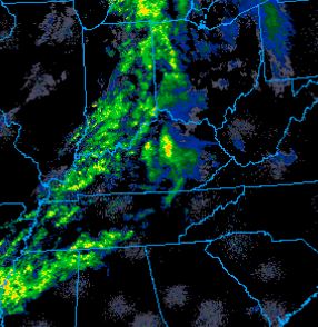
We caught a break from the rain today as the last bits of isolated showers in the region pushed eastward this morning. The high today is 83° with overcast conditions for most of the day. Scattered showers are likely to develop in the late afternoon in south central KY. The low tonight is right at a comfortable 70° with partly cloudy conditions.

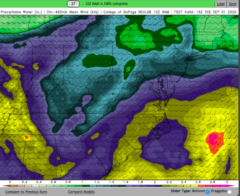
Our next chance of rain comes on Tuesday as a cold front makes its way into the region. The high will be a bit warmer at 86°, and the low will be about 72°. Scattered showers with a few strong winds are expected to begin in the evening hours as a slow moving low pressure system in the upper levels triggers waves of energy towards the Tennessee Valley. The NAM shows areas with 2-4″ of precipitable water from tomorrow night into Thursday. This setup puts most of Kentucky at a marginal risk of severe weather according to the severe thunderstorm outlook. Though, the biggest concern would be for potential localized flooding.

NAM’s predicted precipitable water values for Tuesday. Values increase throughout the region into Thursday night and early Friday morning.

Posted in Kentucky Weather | Comments Off on Rainy Start to the Week!

Cold and Rainy

The rain will continue tonight as a cold from moves into our area, some ice will be possible on bridges and elevated structures in the morning as the low temperature briefly drops below freezing. It will warm up slightly though, with a afternoon high of 37°F. Rain will continue for most of the day Tuesday, finally moving out of our area late Tuesday night. Depending on how quickly the temperatures drop Tuesday night there is a chance for some light snow flurries late Tuesday afternoon, however that does not appear to be likely at this time.
Wednesday morning will be cold! The low temperature will reach 25°F Wednesday morning, however it will be slightly warmer Wednesday afternoon, the high temperature is expected to hit 41.

Posted in Kentucky Weather | Comments Off on Cold and Rainy

Cold front

I use many weather application, continuing radar and satellite images. Some of this application have options to give you warning for any progress that come up within time. Anyway, last night about 12pm one of them gave me a warning for light rain will accrue after 10 minutes. I saw outside to see the sky condition but no single cloud was present. I decided to stay until to see this rain although I was sleepy but nothing occurred. I don’t know from where that’s warring comes from but I know that it difficult to predict the weather and we must rely on weather forecasters more rather than fully depend on whether models because the weather modules give the output based on the input. The problem because if the input was wrong, how does the output look like? That was happen last night!

surface map showing a massive cold front : NWS

The situation right now, a cold front with moderate humidity crossing the area heading east, causing temperatures to drop and forming a cloud cover that lasts even for days (see figure 1). The high temperature will be around mid-50 and then it will drop down to mid-30 this night. We will have some rain but amount of this rain is less than a tenth of an inch possible. For Saturday and Sunday, a high surface pressure will allow to open the blue sky for Saturday. The surface high pressure will have shifted to east to the coast which allows for returning flow to send Gulf moisture back to Kentucky. Therefore, Cloud cover will increase Sunday to Sunday night and result for a slight chance of light rain.

Summary for next few days

Day and time Condition High(°F) Low (°F)
Tonight Mostly cloudy   35 
Saturday Mostly Sunny 52   
Saturday Night Partly Cloudy   38 
Sunday Cloudy 56  
Sunday Night   Slight Chance
Rain then
Chance Rain
  47 
Posted in Kentucky Weather | Comments Off on Cold front

I hope everyone had a great Thanksgiving

I hope everyone had a great Thanksgiving and holiday weekend, despite the cold wet start to this week. Tuesday morning, we are looking at a low temperature of 31°F, and only reaching a high temperature of 43°F by Tuesday afternoon. It will remain cloudy all day, and will likely remain dry, however there is a slight chance for some very light rain around 3pm.

Wednesday will be dry and partly cloudy, with a morning low around 30°F. Wednesday afternoon will be a bit more comfortable as the high temperature reaches 50°F.

Posted in Kentucky Weather | Comments Off on I hope everyone had a great Thanksgiving

Cloudy cover

I was talking to a friend yesterday that I miss the smell of rain that smells out of dry ground when it rains. Of course, we cannot find that smell here in Bowling Green because the surface is saturated all the time with water due to the continuous precipitation from time to time and there is no significant interval to dry the surface of the Earth, and thus find the characteristic smell after the rain. Maybe if we travel to semi-desert areas like Arizona or South Texas and we could find this smell. Nevertheless, we miss this smell but there are other rain features that we can see during or after precipitation that cannot be seen elsewhere. For example, fog after rain, intermittent drizzle, low cloud speed, etc.

A satellite images showing the cloud cover over the region: https://weather.cod.edu/

Follow up with my friend Mathew on this blog, this day will be mostly cloudy that were noted across the region early this morning. the weather radars are showing moderate to light rain showers moving around Warren county.  The high temperature is low 50 °F and low will be around 40 °F.  A surface cold front was roughly along the Ohio River and moving eastward-southeastward.  A cold moving to toward to us and it will approach here soon within hours and we expect the cloudy skies to continue with light to moderate rain to continue as well.

Summary

Day and time Condition High(°F) Low (°F)
Tonight Chance Rain   42 
Saturday Rain Likely
then Chance
Rain
54   
Saturday Night Mostly cloudy   31 
Sunday Mostly Sunny 50   
Sunday Night   Partly Cloudy   32 
Posted in Kentucky Weather | Comments Off on Cloudy cover

Wet Weather Moving In

While we are dry for now, showers have already pushed into Western KY and will continue moving eastward throughout the day. This first broken line of showers will arrive in BG in the next few hours. The majority of these showers will be light in nature and become more scattered as they approach Warren and the surrounding counties. The evening looks dry, but heavier rain showers will move in overnight. Despite the warm push of air from the south, dense cloud cover will keep us right around 60 today.

Friday will start off wet, but we should dry out for the evening hours. Models indicate that we could see rain totals of 1-1.5″ once all is said and done. Morning lows will be quite warm, only dropping into the upper 40s. They won’t move much throughout the day with highs hovering in the low 50s.

Saturday will be cool and start off rainy much like Friday, but the rain will be lighter in nature. Highs will once again hover around 50 and skies will be cloudy throughout the day.

Sunday will be the dry day over the weekend and skies will clear out early to make for a nice day. Temperatures will start off in the mid 30s and rise to the mid 50s. After the cool weekend, things will warm up closer to 60 for the first couple days next week.

Posted in Kentucky Weather | Comments Off on Wet Weather Moving In

Early Travel Forecast

We are a week out from one of the biggest travel holidays of the year! Whether you are flying across the country or driving across the county, weather can have a major impact on your travel plans. Here’s a quick look at what we are expecting for KY and TN next week.

After a fairly mild day Tuesday, a cold front will be moving across the Commonwealth of KY and the TN Valley bringing with it a line of showers on Tuesday into Wednesday. Temperatures will be in the upper 40s throughout both states on Wednesday with morning lows dipping below freezing on Thursday. Thanksgiving day will be cold just like the previous day and even a little breezy at times with periods of rain. If your family is taking any photos to send with those Christmas cards, they’ll likely have to be done indoors this year. But the rain doesn’t stop on Thanksgiving Day: there’s a chance for rain each day Friday-Sunday. At least there will be a warm up expected for the weekend as temperatures jump into the 60s on Saturday.

Overall, an early look at the weather doesn’t quite look like it will be cooperating throughout most of the Holiday celebrations; however, we are still a week out, so things still have potential to change for the better. Just keep in mind that your flight planes might be changing to and from your Holiday destinations if you are flying out of or into Louisville or Nashville next week.

Posted in Kentucky Weather | Comments Off on Early Travel Forecast

A Little Warming Trend Ahead

Overall it has been a cold first half of November; in fact, we are on track to be the fifth coldest November on record with an average temperature of 41. The particularly cold spell at the beginning of last week helped get us to this point, but our chance of staying in the top ten coldest Novembers will diminish as we warm up over the next few days.

Tonight will be cool and calm, with a chance for some fog throughout the region overnight. Morning lows will start in the mid-30s, so don’t forget to grab a jacket before heading out the door tomorrow.

Wednesday will be mostly sunny and mild with a high of 55 as high pressure moves directly over the Commonwealth.

Wednesday night will continue to be warm with clouds increasing overnight ahead of an approaching system.

Morning lows on Thursday will dip to only 40, and it will stay mild throughout the day as a warm front brings additional heat and moisture to the Ohio and Tennessee Valleys. Cloud cover will be dense most of the day, but highs will top out around 64.

Thursday night will start to take a turn late as rain develops ahead of a cold front. Temperatures will stay in the low 50s throughout much of the night. The rain will likely hold off until the early morning hours on Friday.

Friday through the weekend will be cooler with increased rain chances for the first half of the weekend.

Posted in Kentucky Weather | Comments Off on A Little Warming Trend Ahead

Cool and cloudy days ahead

Tuesday morning temperatures will be in the upper 30s under overcast skies, with the chance for some light sprinkles throughout the morning. It will remain mostly cloudy all day, as temperatures rise into the mid 50s, with a slight chance for some more light rain around 2:00pm.
Tuesday night will be dry but cloudy, keeping temperatures in the low 40s overnight. Cloud cover will remain all day Wednesday, limiting the high temperature to a cool 48°F.
Wednesday night the temperature will drop back to 40°F before midnight, however a warm front will move through the area early Thursday morning, raising the temperature back to the mid-40s by sunrise. The warm front will also bring more some more showers into the area early Thursday afternoon.

Posted in Kentucky Weather | Comments Off on Cool and cloudy days ahead

Mercury at perihelion

   I wouldn’t like to miss this a unique astronomical event that is happened this week because we don’t do a public direct observation of solar system planets all the time. This time on November 11, 2019 Mercury passed directory in the front of our sun and it was visible through telescope. It was a small beautiful black dot crossing the sun`s face (see fig 1). It was visible here in US because the transit began at morning time.  Note that the last transit of Mercury was in early 2016 and the next one we might see won’t be until 2023.  The current location Mercury today at this time is at perihelion which mean the location where the Mercury close to the Sun.  

Figure 1: Left hand side, Mercury is crossing the Sun. Right hand side: Mercury at perihelion at 11:05 CST on 16 Nov 2019

The Current weather conditions at Bowling Green is fair and the temperature will reach to high 40s °F. The night will be cold with low temperature at mid-20s °F with mostly clear. No significant weather during this weekend by analysis the synoptic scale we could related the stable condition to the surface high pressure dominate at the region (see fig 2). Therefore, the weekend will be dry weather and sunshine mixed with clouds in some times.

Figure 2: Current surface map at 11:00 CST: NWS

Summary

Day and time Condition High(°F) Low (°F)
Tonight Mostly Clear   25
Saturday Sunny 49  
Saturday Night Mostly clear   25 
Sunday Mostly Cloudy 51  
Sunday Night  Mostly Cloudy   32 
Posted in Kentucky Weather | Comments Off on Mercury at perihelion