Fall Is Here

Fall is officially here, and it brought a cold front and some cooler temperatures with it. After spending most of last week in the 90s, the high-pressure system that has been keeping temperatures hot has finally broken down. After last week today’s high of 85°F felt pretty nice and tonight will be even better as we kick of fall with a crisp night as the temperature drops to 55°F under clear skies.

Tuesday will be sunny and slightly cooler with a high of 80°F. Clouds will begin moving into the area Tuesday night as the temperature drops back down to the mid-50s.

Posted in Kentucky Weather | Comments Off on Fall Is Here

High: 89 °F

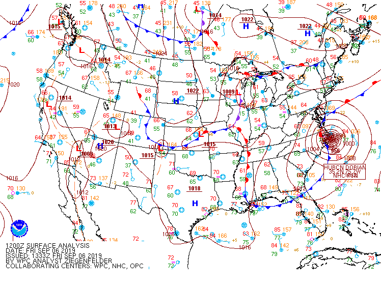
It is a good day because we would see a chance of sprinkles during day time and the high temperature will be near to 89 °F. I currently hear the wind moving the tree`s branches with speed about 9 to 13 mph. Scatter cirrus clouds are dominated at this time which mean we could say it is sunny and it will remain sunny and mostly clear at this night due to high pressure and hot ridge over the region (see figure 1) which keep dry and relatively warm weather for this day and next day.   


Figure 1: surface map (WPC)

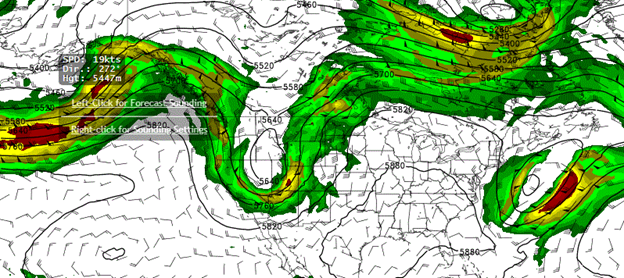
The synoptic analysis gives us a good news for next few days. The 500 mb`s map (see figure 2) illustrates a trough and becoming positively tilt during next week bushing toward Great Lakes and Central or Ohio Valley. This will bring a chance of rain for most of Ohio Valley but still the chance of precipitation will be weak over South- Central of Kentucky to just 20-30% on Monday because the precipitation will split and disintegrate south and east and will not be concentrated in one side.


Figure 2: 500 mb (GFS)

Summary

Time High (°F)Low (°F)
Friday night (Mostly Clear) 62
Saturday (Sunny)90 
Saturday Night (Mostly Clear) 64
Sunday (Mostly Sunny)92 
Sunday night(Chance
T-storms
 65

Posted in Kentucky Weather | Comments Off on High: 89 °F

Cooler Temperatures in Sight

Good afternoon everyone!

While today will still be pretty warm we do have some cooling temperatures in sight. That nasty ridge that has been keeping these summertime conditions looks to be pushed off by early next week which will better allow for some nicer temperatures. Temperatures are expected to reach 95° today. Tomorrow will cool a little to 93°. Friday will be closer to 90°. There is a slight chance for spotted showers Thursday and Friday night.

Have a fun, safe week!

Posted in Kentucky Weather | Comments Off on Cooler Temperatures in Sight

More Heat

It was another hot day today; we reached a high temperature of 95°F under sunny skies. We do however have a slight chance for isolated thunderstorms this evening, and we can expect cloud cover to increase into the night. Overnight expect partly cloudy skies and a low temperature of 71°F.
Tomorrow is looking to be another hot day, as temperatures return to the mid-90s. The cloud cover should clear up throughout the day, however partly cloudy skies will return tomorrow evening. Tomorrow night we will cool off again as the temperature drops into the upper-60s by Wednesday morning.
Wednesday will again be hot and sunny, as high temperatures return to the mid-90s

Posted in Kentucky Weather | Comments Off on More Heat

Harvest Moon


Some people feel pessimistic because of dry weather and lack of rainfall but they may not know that the current weather is a perfect for farmers so far because it is time to dry up their crops and harvest it. What I do know is that tonight the United States will have passed through a rare astronomical phenomenon that only recurs once every 30 years. Harvest Moon is a traditional name among the farmers and it is anther name for full moon. It is called Harvest Moon because it comes at the height of the harvest during three days and it will be available to see for most people who live in US. According to NASA, this moon was historically aided in a special way for farmers who used to rely on moonlight during the harvest. I am happy to see the tonight`s moon because it is a very rare event as will be the first visible moon that across the United States. The last one was in October 13, 2000. The next full moon is unlikely to happen again for another 30 years on August 13, 2049.

The weather will likely remain calm, stable and hot with high temperature 96 °F and low 67 °F except we might see isolated showers and thunderstorms in some parts. This night will be partly cloudy and variable wind after midnight. In synoptic scale, a cold front is moving now to Indiana and western Kentucky. It it is not deep moist convergence but with deep layer shear after few hours, there might be rain, lightning and gusty wind during this night.


Summary for next few days

Day

Max (°F)

Min(°F)

Saturday (Sunny)

89


Saturday Night (Mostly Clear)


61

Sunday (Sunny)

92 


Sunday Night (Mostly Clear)


63

Posted in Kentucky Weather | Comments Off on Harvest Moon

Weekend “Cool Down”

Near record heat once again for this mid-September day. We peaked out at 96 degrees, which is only 2 degrees off the high set back in 1939. While Kentucky natives know full well that it is not unheard of for start of September to be quite hot, it’s worth noting that we have been running 10+ degrees above average for the past few days. Tomorrow will be hot and dry once again. We’ll be waking up to temps in the low 70s and ending up around 95 for our afternoon high. Humidity will be a big factor with DPs near 70 just like today.

However, things will change just a little bit as we move past Friday. A cold front will sweep through the area bring a very slight change of some showers late Friday night. Behind the front is where we’ll find our relief: cooler, drier air. Highs will still be above our average of 84 for this time of year, but the DPs will finally get knocked down into the low 60s. If you have any gardening or lawn care plans this weekend, Saturday is definitely the more pleasant day to get those outdoor tasks completed.

While Sunday will be hot with temps in the low 90s, it won’t feel too oppressive considering the DPs will still be around 60. Lows for both Sunday and Monday morning will be around 65 degrees.

With mostly clear skies and highs near or above 90 for the next few days, it’s weekends like these that make us wish that the pools stayed open just a little while longer. If you have access to one, maybe get out there and enjoy a good cookout with family and friends if at all possible. Otherwise, make sure to stay hydrated at any outdoor events such as the big WKU vs UofL game Saturday at 3:00. No, beer does not count as a source of hydration and can even exacerbate the problem when people are dehydrated. Again, stay safe and enjoy your weekend!

Posted in Kentucky Weather | Comments Off on Weekend “Cool Down”

Eww

Unfortunately it has been nothing but hot and muggy lately and that does not look to change. A strong upper level ridge has planted itself over top of us causing these conditions to remain. There’s not much to say other than to just hold on the best you can for fall and winter will be here before you know it!

  • SUMMARY:
    • Wednesday:
      • High: 95
      • Low: 70
    • Thursday:
      • High: 94
      • Low: 69
    • Friday:
      • High: 95
      • Low: 68

Stay safe and have a great week!

Posted in Kentucky Weather | Comments Off on Eww

HOT as FIRE

The teacher that passed me on the sidewalk today summed up the weather just right: “Boy, oh boy, is it hot out here!” In fact, the Bowling Green airport reported a high temperature of 98, which is only 2 degrees off the record for Sept. 10th set back in 1919. If nothing else, at least the dew points remained in the mid 60s all day, so it wasn’t oppressively humid.

Now that the sun has set and a shower passed through the area, temps have dropped back into the upper 70s. Tonight’s rain was the first recorded rainfall for the month of September.

Tomorrow will be hot once again, and the possibility for a pop-up storm exists during the afternoon hours. Expect a high near 96 and DPs around 70 making for a very hot and humid day. The chance for/type of rain will be much like what we saw today: very slight and short-lived.

Thursday and Friday will both be in the mid 90s and just as humid as tomorrow without any rain for relief.

Considering how hot it will be the next few days and how low our rain chances are, it will be important water the lawn during the cool morning hours and to put the lawn mower at a higher setting. This will prevent a loss of moisture from the grass throughout the day. Healthwise, make sure to drink plenty of water before, during, and after any outdoor activities. Heat indices will be above 100 through Friday, so make sure to keep a close eye on family members that have to be outdoors for an extended period of time.

Posted in Kentucky Weather | Comments Off on HOT as FIRE

Another Hot Day

Today was another hot day here in Bowling Green as our high temperature reached up into the low 90s across our area. While the heat may be unpleasant, the sunshine is certainly appreciated as we enjoy our last few weeks of meteorological summer.

Tonight, high pressure will remain dominate in our area, keeping sky conditions clear overnight. These clear skies will be allowing our overnight low to drop to 65°F, providing brief relief from the heat.

This relief will be short lived however, as high pressure will remain dominate throughout the day Tuesday leading to another hot and sunny day. Our afternoon high will reach the mid-90s, with unpleasant dewpoints in the upper 70s contributing to another hot and muggy day.

Tuesday night looks to again be mostly clear, with another slight break from the heat as our temperatures drop to 70°F overnight.

Posted in Kentucky Weather | Comments Off on Another Hot Day

The Weekend Time

Surface map from the WPC

I could say that this past week was a wonderful because of blue sky and calm weather but it was uncomfortable for some people especially during mid-days. the weather will continue the same scenario with high temperature rise up to 89 °F this afternoon and dew point at mid 65 F°. It is sunny day and uncomfortable since the dew point has a high value. The night time will be slightly different because the night will be partly cloudy and there will be a chance for light rain with low temperature drop to 65 °F. in synoptic scale, the cold front is dropping across the Midwest, meeting a low level moisture and continue to move into southern Indiana and central Kentucky. This will enhance some instability which will suggest isolated to scattered showers and develop some storms along and ahead of the front but if any storm will be developed, it will likely be weak.

Moving to hurricane Dorian`s news, the hurricane is moving to north west along Northern Carolina coastline. the system will continue moving at same path and dragging the cold front into, and moisture air from Great lake.

Overall, high temperature will be between mid and upper 80s this afternoon and next few days and low will be between upper 60s and lower 60s. This weekend weather will be between clear sky and partly cloudy as it is showing in summary.

Summary

Day Condition High ( °F ) Low ( °F )
Saturday Mostly Sunny 83  
Saturday Night Mostly Clear   59
Sunday Sunny 87  
Sunday Night Mostly Clear   63

Posted in Kentucky Weather | Comments Off on The Weekend Time