The Severe Weather Outbreak

Surface Observations (Source: College of DuPage)

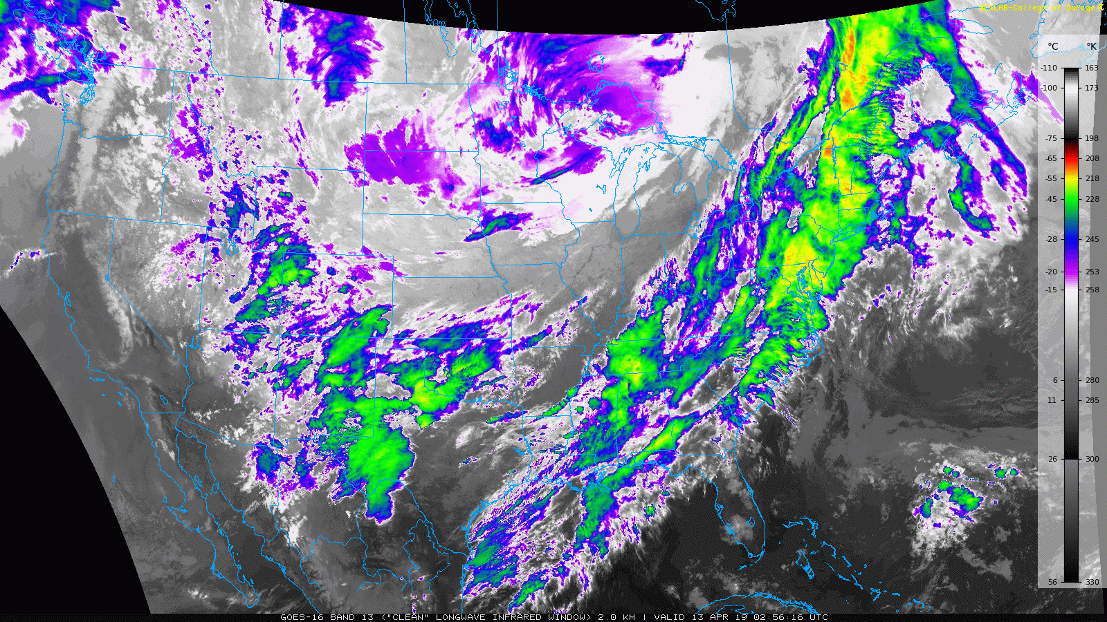
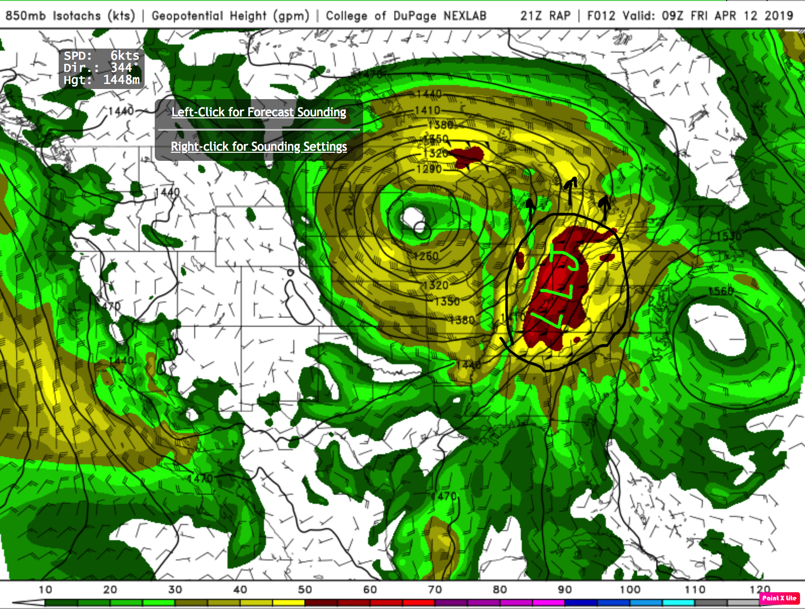
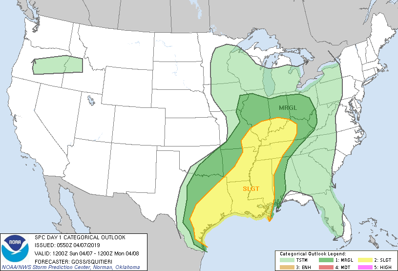
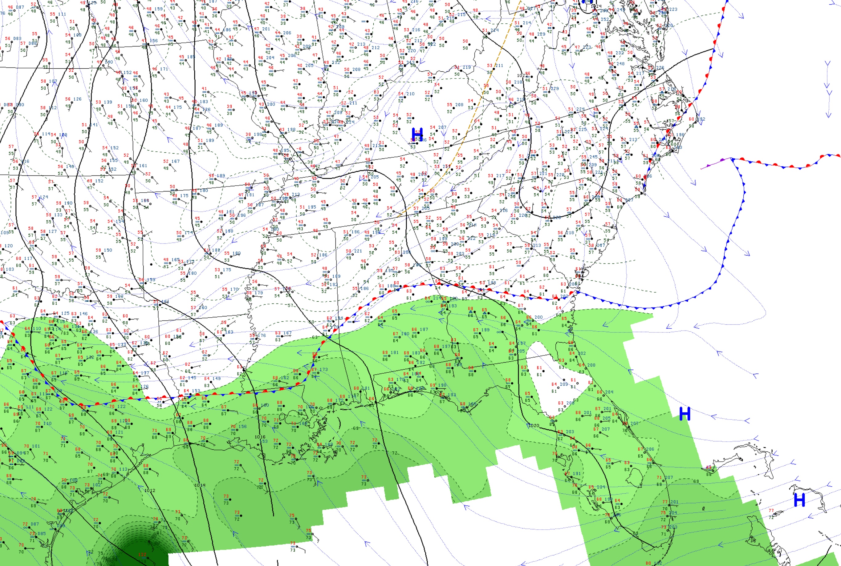
We make a return to severe weather for our weekend; however, it will have to wait until the evening and overnight hours for those in Bowling Green as the place to look at is down in Louisiana. It may not be shown explicitly, but the low pressure center lies over central Texas on the above surface map. This low pressure system will move northeastward and will deliver the storms to the mid-South. Why is Louisiana the place to look at today? The map shown below shows a moderate risk for severe weather that covers the northern part of the state. Louisiana shows the highest risk for tornadoes, at 15%. The chances for wind damage is nearly a coin toss, and hail chances are also significant. For more information, visit the Storm Prediction Center.

Day 1 Severe Weather Outlook (Source: SPC)

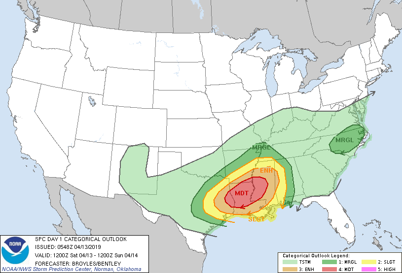
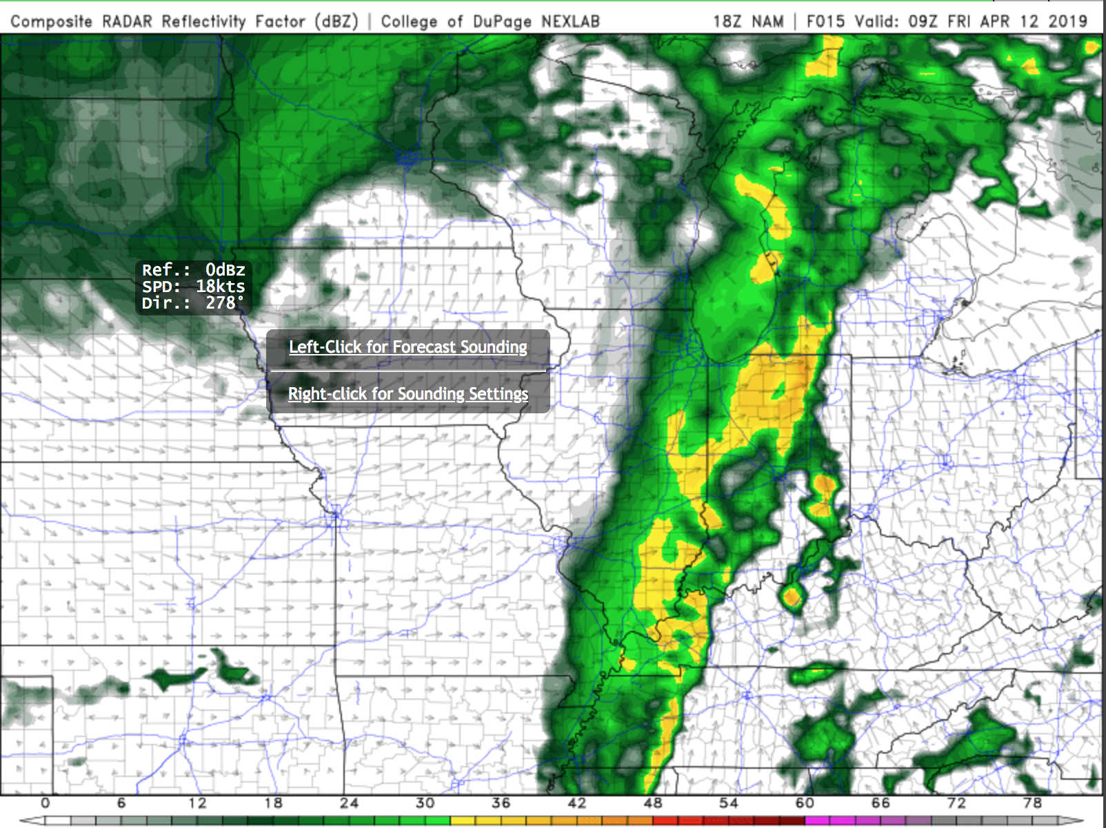
Louisiana and some parts of the Bible Belt will expect to see the greatest chances of severe storms in the late afternoon, where a line of storms and some isolated cells will pass through. The storms have a very high chance for damaging winds, hail, and a few tornadoes. I urge that you seek shelter when they arrive.

6Z NAM NEST Simulated Reflectivity (Source: College of DuPage)

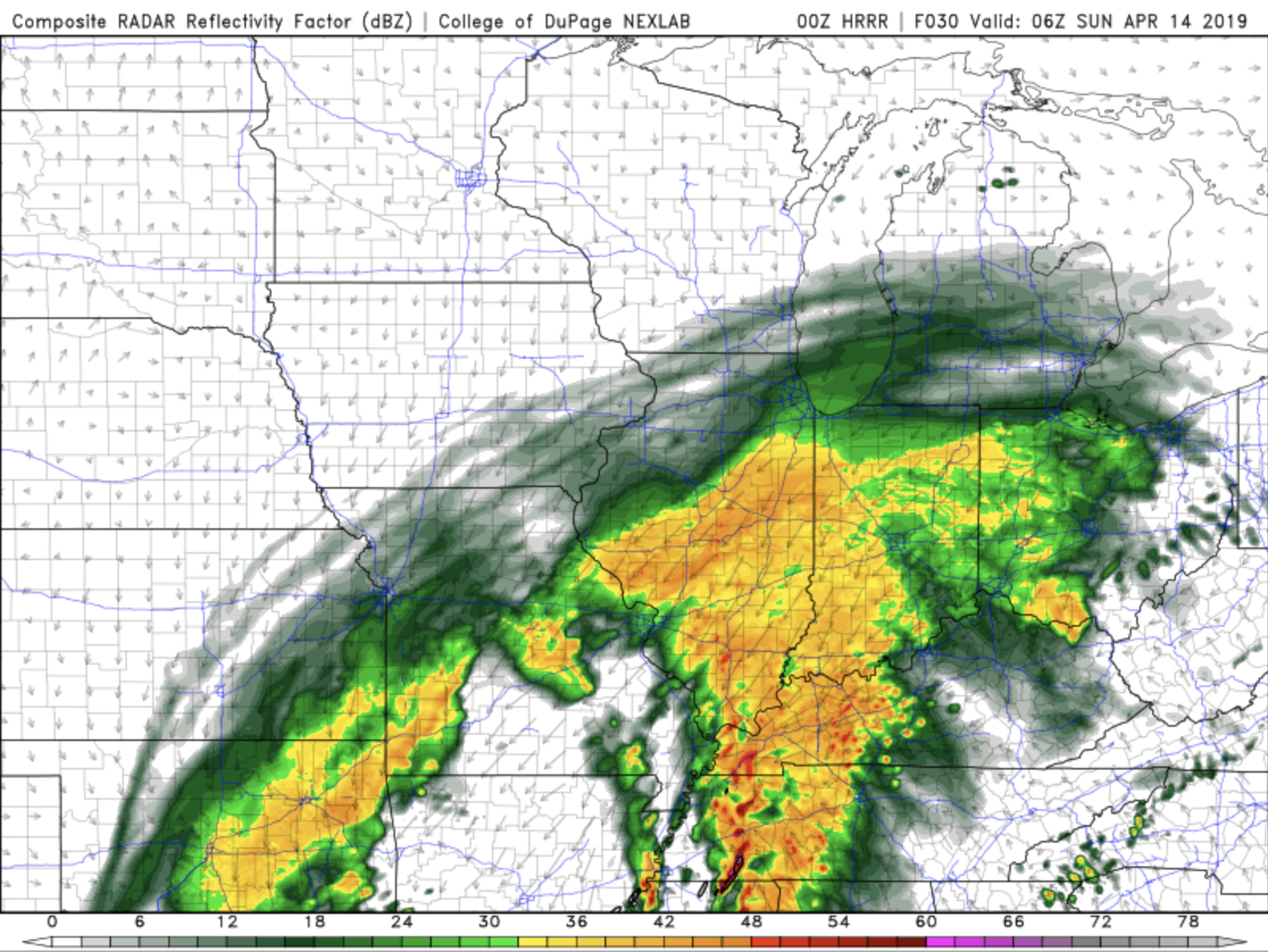
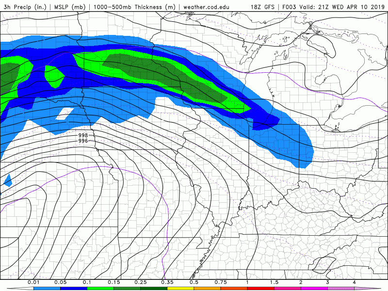
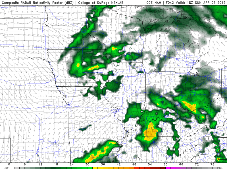
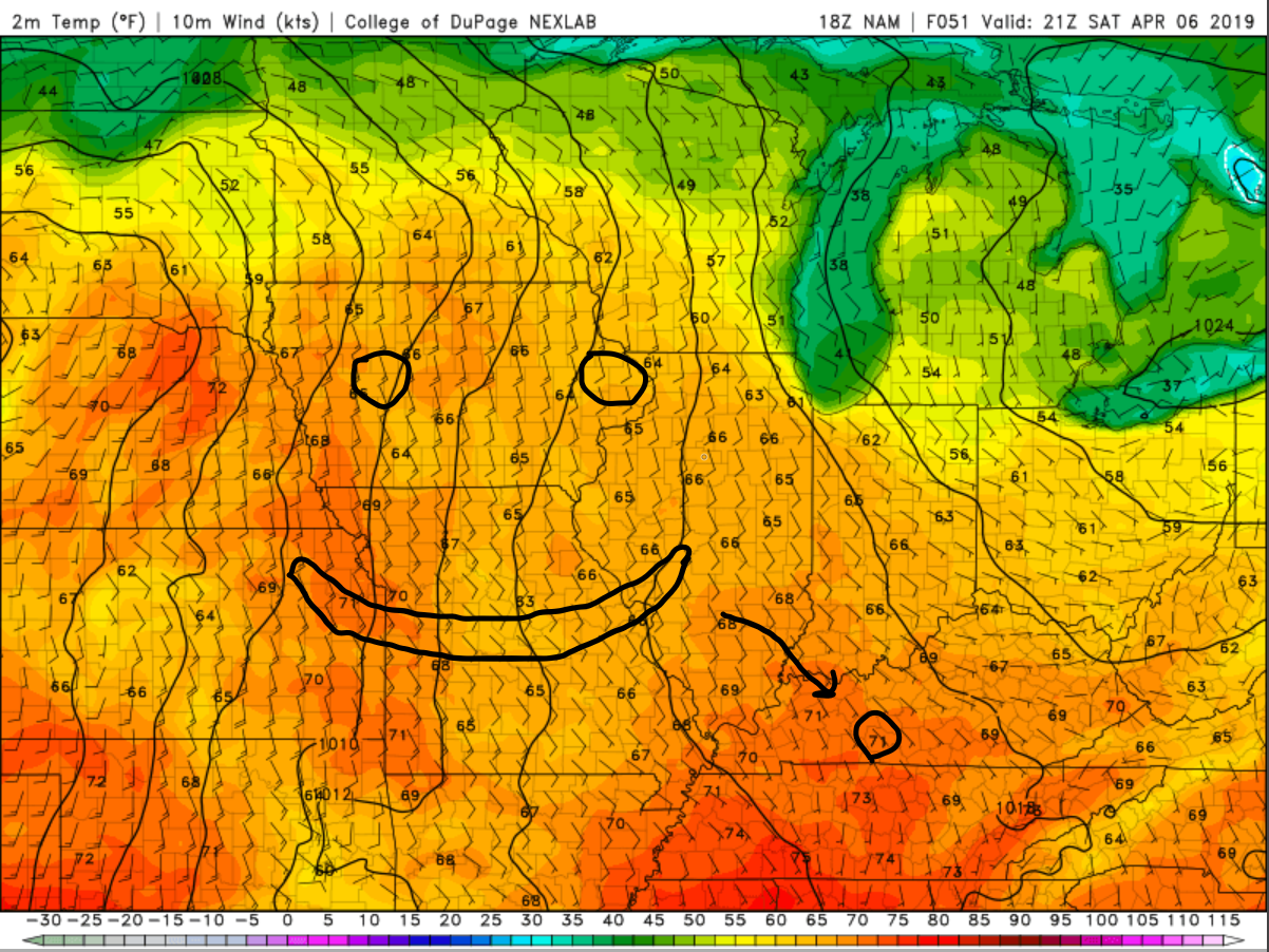
As discussed before, the storms will move into the mid-South for the evening and overnight hours. Keep the chances for damaging winds, hail, and tornadoes in mind when you go to bed tonight. Highs for today will be in the upper 60’s for the Bowling Green area, with lows in the mid 40’s.

6Z NAM NEST Simulated Reflectivity (Source: College of DuPage)

The storms will continue for Sunday morning and early Sunday afternoon, with highs in the upper 60’s, and lows in the lower 50’s. Otherwise, it will be mostly cloudy with clearing overnight.

Today: Cloudy; 20% chance for rain and thunderstorms in late afternoon. High: 64

Tonight: 100% chance for strong to severe thunderstorms; Low: 45

Sunday: Morning thunderstorms; otherwise, mostly cloudy; High: 63, Low: 52

Posted in Kentucky Weather | Tagged | Comments Off on The Severe Weather Outbreak

Here Comes the Rain Again…Cue Eurythmics Song

The clouds continue to thin out and even clear in some places across the region thanks to the departing frontal system that also brought our cooler temperatures.

IR Satellite imagery valid for 10:02pm CDT

The low pressure that brought the rain to the region this morning is currently wrapping itself up and dissipating. This system brought some high snow totals by April’s standards to parts of the northern midwest.

Set-Up:

For us here in the commonwealth however, the weather will be much calmer and warmer at least for now. Saturday we will the clouds increase yet once again ahead of the next frontal system ejecting out the Texarkana region. The frontal system will bring showers to our region by late Saturday evening. A few rumbles of thunder will be possible with some of the more vertically developed convection.

The main show, however, will head our way Sunday with multiple rounds of storms. Some could be strong to severe. The main threats associated with these are large hail, damaging winds, and an isolated tornado cannot be ruled out with the impressive shear values over the region.

HRRR Simulated Reflectivity Valid for Sunday @ 1am CDT

36 Hour Forecast:

Tonight: Lows in the 50s under mostly cloudy skies.

Saturday: Isolated shower chances for the early afternoon with highs in the upper 60s.

Saturday night: Showers and Thunderstorms likely after 9pm. Lows in the upper 50s to low 60s.

Sunday: Showers and Thunderstorms likely in the afternoon with highs in the mid 70s. Winds out of the S at 15-18 mph gusting at times up to 30.

Make sure to stay weather aware this weekend by following these social media platforms:

@wkustormteam @WKUweather

Have a safe and fun filled weekend.

Posted in Kentucky Weather | Comments Off on Here Comes the Rain Again…Cue Eurythmics Song

The Pleasant Weather Comes to an End

Good evening folks!

Taking a look at the current surface observations across the area, temperatures are still sitting around the 80-degree mark with dew points rising a little into the middle 50s. The current surface observations are showing much of the Ohio and Tennessee River Valleys in the warm sector, out ahead of the approaching surface low, centered over NW Iowa. This low will continue to push off to the NE into Minnesota and eventually into the southern part of Ontario, dragging a cold front behind. This cold front will eventually make its way to our area.

Figure 1: COD Surface Analysis

Lets play a little game called, “Who can point out the center of low pressure and its fronts?”

Figure 2: COD Surface Analysis (Drawn in fronts/pressure center)

As we head into the late evening and early morning hours, LLJ (Low-Level Jet) at 850mb will kick into gear with winds racing in from the SSW at around 40-50 knots. Why is this concerning, because this will aid in the development of thunderstorms. The LLJ provides extra moisture and lift for thunderstorms to tap into and aid in development.

Figure 3: COD RAP 850mb Winds & Heights 09Z FRI APR 12

As the LLJ ramps up, better forcing associated with the approaching cold front will move into the area early in the morning on Friday. Model guidance is indicating that a line of thunderstorms will move through the area sometime early Friday morning. The threats associated with this line are low, but you can’t rule out some areas within the line to produce strong winds and some small hail. Wind shear values (wind speed and direction changing with height) across the area are low, making the tornado threat quite low. Model guidance is also indicating at some pre-frontal convection developing across the area thanks to the strong surge of moisture coming in from the south.

Figure 4: COD NAM Composite Reflectivity 09Z FRI APR 12

Showers and remaining t-storms will move out of the area as Friday progresses leaving behind a mild afternoon with skies becoming mostly sunny with high hovering around the 70 degree mark.

Heading into Saturday, moisture will begin to return into the area from the south ahead of another approaching storm system. This system will cut across the Tennessee and Ohio River Valleys. A couple rounds of soaking rain with embedded thunder will move through the area during the evening and overnight hours on Saturday. Highs around the area on Saturday will hover around the 70 degree mark once again.

Figure 5: COD NAM 24hr Precip. Accumulation 06Z SUN – 06Z MON

If you have plans for this weekend, especially Saturday evening you might need to pack the umbrellas. Rainfall totals associated with the weekend system will approach the 1-inch mark.

The weekend system will race off towards the east heading into Monday, leaving behind mostly sunny skies, with cooler temperatures reaching the lower 60s to start of the work week.

Tonight: Scattered showers and thunderstorms during the early morning hours, lows will hover around the 60 degree mark with winds around 15-20 mph.

Friday: Cloudy, then gradually becoming mostly sunny, with a high near 70. Southwest wind 9 to 11 mph, with gusts as high as 22 mph.

Saturday: A chance of showers, with thunderstorms also possible during the evening/overnight hours. Mostly cloudy, with a high near 69.

Sunday: Showers and possibly a thunderstorm. High in the low 70s, with breezy conditions.

Posted in Kentucky Weather | Comments Off on The Pleasant Weather Comes to an End

Will the Warmth Last?

It was yet another sunny day in Bowling Green as we warmed to a high of 79° in the afternoon. Tomorrow could be even warmer!

Model: 0Z HRRR, Temperatures

We could beat Wednesday’s high of 79°. Winds will come from the south, bringing us a shot of warmer air- and potentially getting us to the lower 80’s. However, the price for this warmer weather is the chance for thunderstorms and gusty winds!

Model: NAMNEST, Simulated Reflectivity
Model: NAMNEST, Wind Gusts

As shown by the models above, a line of thunderstorms with gusty winds should arrive in the early morning hours on Friday. This isn’t looking like a strong event, but something for those allergen sufferers to look forward to. The pollen count has been high, coming in at 11.7 today (extreme!). Besides Friday morning, it appears there will be two more chances at rain before the weekend comes to a close.

Model: GFS, Precip

Unfortunately (or fortunately, again for those with pollen allergies), it looks like there will be a few rounds of rain this weekend. The GFS model above paints a wet picture for the next few days, especially this Sunday. With these systems moving through, we should also cool down this weekend quite a bit from what we’ve been experiencing as of late.

After 80’s Thursday, temperatures will crash back down to 50’s and 60’s as colder air works its way into the Mid-South. Sunday should warm up again before more rain arrives, but overall the pattern looks a bit cooler than average. This is why NOAA is forecasting a 30-50% probability of below normal temperatures for the region. With the active pattern ahead, we could be in for a back-and-forth swing in temperatures over the next two weeks!

Summary:

-Thursday warms back up to the lower 80’s

-Thunderstorms and gusty winds Thursday night into Friday morning

-Wet and cooler in the days to come

Posted in Kentucky Weather | Comments Off on Will the Warmth Last?

A Beautiful Day!

Good afternoon everyone! This morning started off a little rough for some drivers as we had all that fog sitting over the area. Luckily by about 8:30 the majority of that fog had cleared out leaving a gorgeous, sunny day! Satellite imagery isn’t showing a lot over our are other than some clouds that are straggling behind the rain that is still hanging onto the east coast. A cold front is coming our way which will help keep temperatures comfortable for us.

There are some showers and storms in the west that will head our way, but they will not arrive until Thursday night into Friday. For now sit back and enjoy the sunny weather! There is the possibility that some areas in Kentucky could see 80° Thursday. Bowling Green looks to stay just below that as the rain tries to push its way into the area.

  • SUMMARY:
    • Tuesday:
      • High: 78
      • Low: 46
    • Wednesday:
      • High: 78
      • Low: 59
    • Thursday:
      • High: 79
      • Low: 54
      • Storms and showers will push into the area later at night towards Friday morning.

Have a fun, safe week everyone!

Posted in Kentucky Weather | Comments Off on A Beautiful Day!

Wet Start To The Week

Many of you woke up this morning to moderate rain. Luckily, most of that has moved through and to our east. As of now, we are mostly cloudy with temperatures currently in the low to mid 60’s. Moving forward into the rest of your Monday, we will stay mostly cloudy with a chance of some scattered showers this afternoon.

HRRR 14z Precipitation Type

Most of the models are in sync that we will stay mostly dry the rest of the day and into Tuesday. There is a slight chance of some scattered light showers this afternoon, but nothing long lasting or impactful. Moving into Tuesday and mid-week we can expect the sun to return.

NAM 12z Cloud Cover

Clouds will begin moving out this evening/overnight and into Tuesday before much clearer skies take over. Tuesday and Wednesday will feel very seasonal with sunny skies and high’s in the mid 70’s. A week cold front will move through Tuesday leaving us with a low in the mid 40’s Tuesday night. Enjoy the mid-week Spring feel before rain showers return toward the end of the work week.

FORECAST

Today (4/08): Mostly cloudy with a chance of lingering (light) showers this afternoon (30% chance)
High: 69
Low: 54
Tonight: Mostly cloudy with clouds decreasing overnight

Tuesday (4/09): Clouds continue decreasing into Tuesday, leaving mostly sunny skies for the day
High: 75
Low: 46
Tuesday Night: Mostly clear

Posted in Kentucky Weather | Comments Off on Wet Start To The Week

Stormy Sunday

Surface Observations (Source: College of DuPage)

A weak mid-latitude system will make a pass today, bringing rain and thunderstorms, with a chance for storms to be severe. The below map shows a widespread slight risk for severe thunderstorms, which means these storms might have low coverage and varying intensity.

Day 1 Convective Outlook (Source: SPC)

The main threats for this day are wind and hail damage; nevertheless, a tornado is always possible. These storms may have the largest impact for the afternoon and making a pass through the eastern parts of Kentucky and Tennessee for the evening. Highs for Sunday in Bowling Green can reach the mid-upper 70’s, and lows in the mid 50’s.

11Z HRRR Simulated Reflectivity (Source: College of DuPage)

For Monday, there will still be morning showers, but it will remain cloudy for the rest of the day. Highs can reach the mid 70’s, and lows will be in the upper 50’s. Tuesday could be cloudy as well, with some clearing for the afternoon. Highs will be in the mid 70’s and lows in the lower 50’s.

Forecast:

Sunday: Rain and thunderstorms, a few storms may be severe; High: 76, Low: 55

Monday: Morning showers, otherwise cloudy; High: 74, Low: 57

Tuesday: Cloudy in the morning, clearing for the afternoon; High: 75, Low: 52

Posted in Kentucky Weather | Tagged | Comments Off on Stormy Sunday

A Change in Pattern for the Weekend

If you are out driving this morning, please take care and precaution, for there will be fog for the Saturday morning commute. Otherwise, enjoy a sunny day, for a high pressure field centers itself just over Kentucky.

Surface Observations (Source: College of DuPage)

Highs for Saturday will be very enjoyable in the mid-lower 70’s, and lows will be in the upper 40’s. Sunday will see some storm action, and severe weather may return to the mid-South. These storms might be the most intense for the afternoon hours of Sunday. Highs for Sunday could be in the mid 70’s, and lows could reach the mid 50’s. Monday could see similar patterns in the morning, but then it might clear up for the afternoon. Highs for Monday will reach the upper 70’s and lows will be in the mid 50’s.

6Z GFS SLP and Precipitation (Source: College of DuPage)

Forecast:

Saturday: Foggy morning, otherwise Sunny; High: 74, Low: 48

Sunday: Thunderstorms, a few maybe severe; High: 75, Low: 56

Monday: Morning rain/t-storms; High: 77, Low: 55

Posted in Kentucky Weather | Comments Off on A Change in Pattern for the Weekend

Bringing Back the 80s and We’re Not Talking About the Decade!

We were definitely socked in the clouds today and we won’t be breaking out of them for at the least the overnight hours as some higher clouds, represented by the brighter colors in the imagery, start to move in from the west.

GOES- East Satellite Infrared Imagery valid for 9pm CDT

Set-Up:

A stalled out frontal boundary to our south with start to lift northward as a warm front throughout the day tomorrow helping to usher in some much warmer temperatures as well as moisture content. Most of the day on Saturday remains dry. We’ll have to watch out for scattered shower chances out ahead of the approaching warm front. By Sunday we will be well established in the warm sector. Depending of how much sun we will see, storms could be a possibility Sunday evening out ahead of a approaching cold front from the west. Temperatures on Sunday will be flirting with the 80 degree mark for the first time this season! Some of the storms on Sunday could be strong to severe if the instability is able to establish itself over the region. Confidence for strong storms is low at this time. Here is the 0Z(7 pm) run of the NAM model’s depiction of how Sunday COULD unfold.

0Z NAM Simulated Composite Reflectivity valid for Sunday morning around 4am CDT.

Showers possible early Sunday morning ahead of that warm front. The showers should clear out shortly after sunrise keeping a small part of the day dry. Showers and storms return, however, by early afternoon.


0Z NAM Simulated Composite Reflectivity valid for Sunday afternoon around 1pm CDT.

Shower and storm chances hang on for the start to the workweek as another system approaches from the southwest dragging across the TN Valley through the day on Monday.

36 Hour Forecast:

Tonight: We hold onto the clouds overnight with lows falling into the low 50s. Calm winds.

Saturday: Partly cloudy skies with temps in the upper 70s across the region. Winds light out of the SW.

Saturday Night: Scattered showers late with lows staying in the upper 50s. Winds light out of the SW.

Sunday: Showers and thunderstorms likely. Temperatures in the upper 70s to low 80s. Winds out of the S at 7-13 mph, gusting at times to 23.

Stay weather aware this weekend by following these Social Media Accounts:

@wkustormteam @WKUweather

Posted in Kentucky Weather | Comments Off on Bringing Back the 80s and We’re Not Talking About the Decade!

Rain Chances are on the Increase

Good afternoon folks!

A shortwave trough noticeable at 500mb is currently over the eastern Great Plains and will continue to move east into our area heading into tonight. As the small disturbance moves our way, it will bring along with it the chance of some showers. It’ll be soggy for most of overnight hours and gradually clear as the disturbance moves east.

Heading into tomorrow, the rain will be well east of the area and it will dry out. The area will remain under cloud cover. Temperatures during the day will stay in the mid-to-upper 60s.

High pressure will begin to settle into the western parts of the Ohio Valley heading into Friday night and Saturday. Saturday will be absolutely gorgeous with partly sunny skies and highs around the area reaching the low-to-mid 70s.

A more active pattern will setup heading into Sunday as an upper-level trough builds in from the west, allowing the winds to shift to a more southwesterly flow. This will allow more moisture and instability to move into the region. Confidence is still low on the severe weather threat on Sunday, because we are four days away. But as time progresses and we move closer to Sunday, things can definitely change so tune into the WKU Meteorology Blog or WSWX for further updates.

Tonight: Showers likely, mainly between 9pm and 5am. Cloudy, with a low around 54. South wind 5 to 9 mph becoming light southeast after midnight. 

Friday: Mostly cloudy, with a high near 66. Calm wind becoming west around 6 mph in the afternoon.

Friday night: Mostly cloudy, with a low around 52.

Saturday: Partly sunny, with a high near 75.

Sunday: A chance of showers, with thunderstorms also possible after 10am. Mostly cloudy, with a high near 78.

Posted in Kentucky Weather | Comments Off on Rain Chances are on the Increase