First Day of Fall; but Summer Weather Will Continue to Dominate

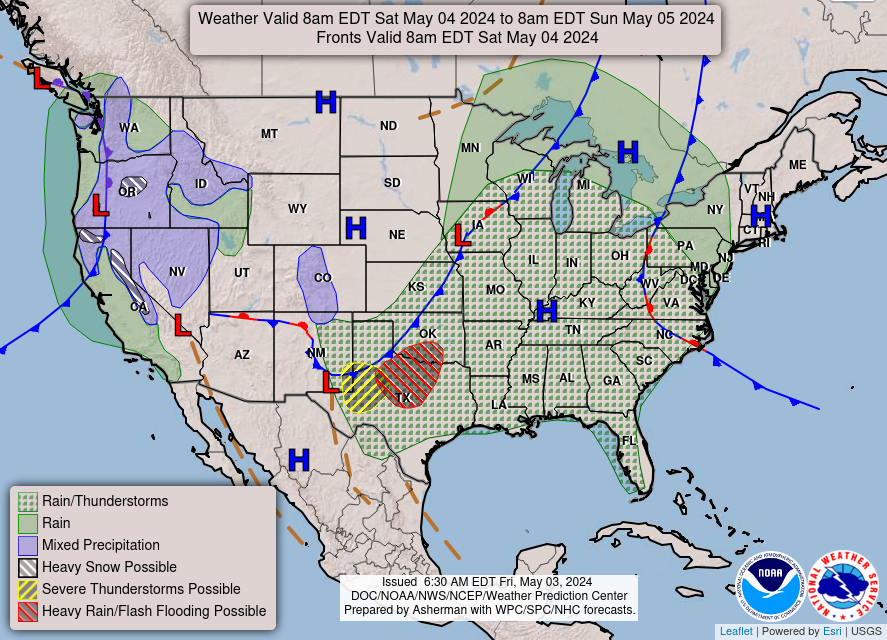
As today officially begins the fall season, the region will continue to experience late summer weather. As the week comes to an end, temperatures will continue to be pleasant and as we enter the last weekend of September a small chance of rain will show.

91fndfd_init_2015092312

Today September 23rd, 2015: High 84

Pleasantly warm weather will dominate the region today with humidity a little higher than earlier this week; but definitely not the air you can wear. Skies will tend to be clear throughout the day but some clouds will be present.

Tonight: Low 57

Skies will clear throughout the evening and into the night allowing the temperatures to drop just below 60 degrees.

98fndfd

Tomorrow: High 88 Low 60

Get out and enjoy the sunshine while you can! Clear skies throughout the day with some cloud cover at night. An extremely pleasant day for your Thursday.

Looking Ahead:

Friday: High of 79, Low of 60. Cloudy skies will give way to periods of rain showers throughout the afternoon and evening.

Saturday: High of 80, Low of 59. Chance of rain early in the day, then staying cloudy for the remainder.

Sunday: High of 80, Low of 60. Bits of clouds and sunny skies throughout the day.

Monday: High 84, Low 60. Mostly sunny skies.

Tuesday: High 85, Low 58. Sunny skies.

In a nutshell:

The upcoming weekend presents great opportunities for outdoor activities besides Saturday morning. Enjoy it!

Posted in Kentucky Weather | 2 Comments

Mild Last Week Of The Summer Season

Quick Overview:


As we enter the last few days of summer we will continue to see temperatures average for this time of year in Bowling Green. Looking towards the week ahead; pleasant late summer weather will grace us. No significant rain events are forecasted for this week as of now, humidity for the region will be pleasant as well as the temperatures; a little chilly, but pleasant, for the nights

Today September 21st, 2015: High 80

91fndfd

Today will be a great day for outdoor activities as we remain in the high pressure system that has been over the region since the weekend. Temperatures in the low 80’s with clear skies. Not too hot, not too sticky, and mostly sunny for the day.

Tonight: Low 50


Skies will remain clear throughout the evening and night which will allow temperatures to drop into the low 50’s.

Tomorrow September 22nd, 2015 High: 82

98fndfd


High pressure will continue to dominate the region keeping temperatures mild and skies clear; yet another great day to be outside. Dew point temperatures will be low keeping the air relatively dry and pleasant.

Tomorrow Night: Low 55

Skies will be clear yet again with temperature in the mid 50’s.

Looking Ahead:

Wednesday: High of 87, Low of 57, beginning to warm up, but not a scorcher. Clear skies throughout the entire day.

Thursday: High of 87, Low of 60, continuing to be milder throughout the day and night but keeping clear skies.

Friday: High of 86, Low of 58, skies becoming partly cloudy: still an excellent day to be outside.

Saturday: High of 85, Low of 56, skies clear.

Sunday: High of 83, Low of 56, clear skies once again.

In a nut shell:

This is a fantastic week to be outside and enjoying the weather, as well as great weather if you want to sit outside and star gaze. Get outside and enjoy it!


Posted in Kentucky Weather | Comments Off on Mild Last Week Of The Summer Season

More Comfortable Days Ahead!

This Evening: Low- 65

We have warmed nicely into the upper 80’s today under clear to partly cloudy skies. More in the way of partly cloudy conditions look to move in as the night moves on, as a weak cold front gets closer to the area.

Tomorrow: High-85 Low-59

A weak cold front looks to push through the area from the northwest late tomorrow morning into early tomorrow afternoon. Due to limited moisture ahead of the front, only isolated to scattered showers and storms look likely with its passage in the area. No strong to severe weather is anticipated with this activity.

Sunday: High-76 Low-53

Surface high pressure looks to move into the region behind Saturday’s weak cold front for our Sunday. This looks to result in very comfortable temperatures and dewpoints accompanied with sunny skies. Our Sunday will definitely be the pick day of the weekend!

Weekly Outlook:

Tonight
Mostly clear, with a low around 64. South wind around 5 mph becoming calm in the evening.
Saturday
Scattered showers and thunderstorms, mainly after 1pm. Partly sunny, with a high near 85. South wind 5 to 9 mph becoming northwest in the afternoon. Chance of precipitation is 30%.
Saturday Night
Isolated showers and thunderstorms before 4am. Mostly cloudy, with a low around 60. North wind 5 to 8 mph. Chance of precipitation is 20%.
Sunday
Mostly sunny, with a high near 76. Northeast wind 5 to 8 mph.
Sunday Night
Partly cloudy, with a low around 53.
Monday
Mostly sunny, with a high near 78.
Monday Night
Mostly clear, with a low around 51.
Tuesday
Sunny, with a high near 81.
Tuesday Night
Mostly clear, with a low around 53.
Wednesday
Sunny, with a high near 81.
Wednesday Night
Partly cloudy, with a low around 57.
Thursday
Mostly sunny, with a high near 83.


Posted in Kentucky Weather | Comments Off on More Comfortable Days Ahead!

Stretch of Nice Weather Continues!

This Evening: Low-56

Afternoon temperatures today in the low to mid 80’s, coupled with mainly sunny skies, have made conditions beautiful to be outside once again!

Tomorrow: High-85 Low-60

As an area of surface high pressure stays centered to our east over the Mid Atlantic region and keeps us in a southerly flow, we should expect our Thursday to basically be a carbon copy of today temperature and sky cover wise. So, tomorrow will be yet another seasonable and mainly sunny day!

Friday: High-87 Low-65

Our Friday looks to offer up temperatures a little above normal for once as that high pressure system stays out to our east, and is allowed to pump in more warmth and moisture. Clouds look to be on the increase late Friday afternoon through Friday night, as our next cold front approaches from the northwest. This front will push through our area  during the day on Saturday, only accompanied with very small precipitation chances. More about the Saturday forecast will be discussed below in the Weekly Outlook section.

Weekly Outlook:

Tonight
Mostly clear, with a low around 56. Southeast wind around 5 mph becoming calm in the evening.
Thursday
Sunny, with a high near 85. Calm wind becoming south 5 to 7 mph in the morning.
Thursday Night
Mostly clear, with a low around 60. Southeast wind around 5 mph becoming calm in the evening.
Friday
Mostly sunny, with a high near 87. Calm wind becoming south around 6 mph in the morning.
Friday Night
Partly cloudy, with a low around 64.
Saturday
A 20 percent chance of showers and thunderstorms after 1pm. Partly sunny, with a high near 85.
Saturday Night
A 20 percent chance of showers and thunderstorms before 1am. Mostly cloudy, with a low around 59.
Sunday
Mostly sunny, with a high near 77.
Sunday Night
A 20 percent chance of showers. Partly cloudy, with a low around 57.
Monday
A 20 percent chance of showers. Partly sunny, with a high near 77.
Monday Night
Mostly cloudy, with a low around 57.
Tuesday
Partly sunny, with a high near 77.


Posted in Kentucky Weather | Comments Off on Stretch of Nice Weather Continues!

Beautiful Weather Ahead!

This Evening: Low-52

After a chilly start to the day, temperatures have rebounded quite nicely all the way into the upper 70’s. These temperatures combined with the ample sunshine have really made today a very nice day to be outside.

Tomorrow: High-83 Low-55

As an area of surface high pressure moves off to our east, temperatures look to warm a few degrees for our Tuesday. These forecast temperatures in the low 80’s combined with sunny skies will make tomorrow yet another great day to be out and about.

Wednesday: High-85 Low-62

Temperatures for our Wednesday look to warm even more from Tuesday as that previously mentioned surface high moves even further to our east, allowing for a southerly flow to develop over our region. Clear skies are yet again expected for our Wednesday, and this in conjunction with these forecast temperatures look to make Wednesday another great day to get outside.

Weekly Outlook:

Tonight
Mostly clear, with a low around 52. Southeast wind around 5 mph becoming calm in the evening.
Tuesday
Sunny, with a high near 83. Calm wind becoming south 5 to 8 mph in the morning.
Tuesday Night
Mostly clear, with a low around 55. Southeast wind around 6 mph becoming calm in the evening.
Wednesday
Sunny, with a high near 85. Light south wind increasing to 5 to 9 mph in the morning.
Wednesday Night
Mostly clear, with a low around 62.
Thursday
Sunny, with a high near 86.
Thursday Night
Mostly clear, with a low around 64.
Friday
Mostly sunny, with a high near 89.
Friday Night
Partly cloudy, with a low around 65.
Saturday
A 30 percent chance of showers and thunderstorms. Partly sunny, with a high near 85.
Saturday Night
A 30 percent chance of showers and thunderstorms. Mostly cloudy, with a low around 63.
Sunday
A 20 percent chance of showers and thunderstorms. Mostly sunny, with a high near 81.
Posted in Kentucky Weather | Comments Off on Beautiful Weather Ahead!

Beautiful and Cool

This Evening: Low- 48

Today has been the coolest day we’ve had in a while. We’ve been having a few showers throughout the afternoon. Our high was in the mid-70’s. There’s a chance for scattered showers this evening.

Tomorrow: High- 70  Low- 47

High pressure moves back in over the region bringing clear skies and warmer temperatures.
Our Sunday should be quiet and absolutely gorgeous.

NWS National Forecast

Monday: High- 80  Low- 53

The high pressure is going to stick around for the next few days, so expect another calm and sunny day. There’s not a whole lot going on due to that high pressure system, so it’s kind of a boring forecast.

Weekly Outlook:

Tonight: Scattered showers and thunderstorms before 7pm, then isolated showers between 7pm and 9pm. Partly cloudy, with a low around 47. Northwest wind 5 to 8 mph becoming calm after midnight. Chance of precipitation is 30%.

Sunday: Sunny, with a high near 72. Calm wind becoming northwest 5 to 7 mph in the morning.

Sunday Night: Clear, with a low around 47. Northwest wind around 5 mph becoming calm in the evening.

Monday: Sunny, with a high near 78. Calm wind becoming south around 6 mph in the afternoon.

Monday Night: Mostly clear, with a low around 54. Southeast wind around 5 mph becoming calm in the evening.

Tuesday: Sunny, with a high near 82.

Tuesday Night: Mostly clear, with a low around 58.

Wednesday: Mostly sunny, with a high near 85.

Wednesday Night: Partly cloudy, with a low around 61.

Thursday: Mostly sunny, with a high near 87.

Thursday Night: Partly cloudy, with a low around 63.

Friday: Mostly sunny, with a high near 87.

Friday Night: A 30 percent chance of showers and thunderstorms. Mostly cloudy, with a low around 66.

Saturday: A 40 percent chance of showers and thunderstorms. Mostly cloudy, with a high near 84.


Posted in Kentucky Weather | Comments Off on Beautiful and Cool

More Rain and Cooler Temperatures

Tonight: Low- 63

Today was definitely cooler than it has been over the past week. The cold front that came through yesterday brought in much needed rain and cooler temperatures. We saw a high temperature of about 89 today, which was a welcome relief.

Tomorrow: High- 80 Low- 57

We have another chance for rain tomorrow afternoon starting in the afternoon. A good majority of the rain will hit about 4pm, according to the current NAM runs. The cause of this is another cold front moving through the area on Friday.

NWS National Forecast
21
NAM Simulated Radar Activity

A second line could form from some of the scattered showers behind the main line around 10pm, according to the NAM and other forecasts. These should begin to work their way out overnight and leave us with a dry Saturday morning.

27
NAM Simulated Radar Reflectivity

Saturday: High- 68 Low- 50

Saturday is going to bring us a huge cool-down in temperatures. This is due to the two cold fronts we’ve seen move through the area over the past three days prior. While the threat for rain isn’t as great on Saturday, there still is a slight chance lingering around for now. The threat is mainly contained in the afternoon and overnight hours. More to come on that as we get closer to it.

Weekly Outlook:

Tonight: Patchy dense fog after 1am. Otherwise, mostly clear, with a low around 63. Calm wind.
Friday: Showers and thunderstorms likely, mainly after 3pm. Patchy dense fog before 8am. Otherwise, partly sunny, with a high near 80. Calm wind becoming northwest 5 to 8 mph in the morning. Chance of precipitation is 60%. New rainfall amounts between a quarter and half of an inch possible.
Friday Night: A chance of showers and thunderstorms before midnight, then a slight chance of showers between midnight and 3am. Mostly cloudy, with a low around 57. Northwest wind around 6 mph. Chance of precipitation is 40%.
Saturday: A 20 percent chance of showers. Partly sunny, with a high near 69. Northwest wind 6 to 10 mph.
Saturday Night: Mostly cloudy, with a low around 48. Northwest wind 3 to 7 mph.
Sunday: Mostly sunny, with a high near 70.
Sunday Night: Mostly clear, with a low around 48.
Monday: Sunny, with a high near 77.
Monday Night: Mostly clear, with a low around 54.
Tuesday: Sunny, with a high near 82.
Tuesday Night: Partly cloudy, with a low around 60.
Wednesday: Mostly sunny, with a high near 84.
Wednesday Night: Partly cloudy, with a low around 64.

Thursday: A 20 percent chance of showers and thunderstorms. Partly sunny, with a high near 84.

Posted in Kentucky Weather | Comments Off on More Rain and Cooler Temperatures

Rain on the Way?

Today: High- 98° Low- 67°

Today was and still is a very hot day here in Bowling Green, KY.

NWS National Forecast

The dominating high pressure forced for mostly sunny skies in the region. Fortunately, the system is moving on to make room for a cold front that could possibly bring us some rain!


 Wednesday: High- 86° Low-66°

Tomorrow is showing promise for a cool down as the cold front moves in and brings with it a chance of rain.

NWS National Forecast


According to the NAM, we should start to see spotty showers around 6am Wednesday morning. The main line of rain should move in soon after. We will have to keep an eye out for precipitation amounts as the ground could be unable to absorb the full amount of rain at that time.

18
NAM Simulated Radar Reflectivity

The greatest chance for rain will begin in the late afternoon/ early evening, so make sure to take your umbrella with you for the commute home.

Weekly Outlook:

Tonight: Increasing clouds, with a low around 69. South wind around 6 mph becoming calm in the evening.

Wednesday: Showers and thunderstorms likely, mainly after 4pm. Cloudy, with a high near 86. Calm wind becoming southwest 5 to 7 mph in the morning. Chance of precipitation is 60%. New rainfall amounts between a quarter and half of an inch possible.

Wednesday Night: Showers and thunderstorms likely. Cloudy, with a low around 68. West wind around 6 mph becoming calm in the evening. Chance of precipitation is 70%. New rainfall amounts between a quarter and half of an inch possible.

Thursday: Showers and thunderstorms likely, mainly before 2pm. Mostly cloudy, with a high near 83. Light west wind. Chance of precipitation is 60%. New rainfall amounts between a tenth and quarter of an inch, except higher amounts possible in thunderstorms.

Thursday Night: A 30 percent chance of showers and thunderstorms, mainly before 8pm. Partly cloudy, with a low around 64. Northwest wind around 5 mph becoming calm in the evening.

Friday: A 20 percent chance of showers and thunderstorms. Mostly sunny, with a high near 84.

Friday Night: A 30 percent chance of showers and thunderstorms, mainly after 8pm. Mostly cloudy, with a low around 60.

Saturday: A 30 percent chance of showers and thunderstorms, mainly before 8am. Partly sunny, with a high near 73.

Saturday Night: A 20 percent chance of showers and thunderstorms before 8pm. Partly cloudy, with a low around 53.

Sunday: Sunny, with a high near 71.

Sunday Night: Mostly clear, with a low around 51.

Monday: Sunny, with a high near 77.

Monday Night: Mostly clear, with a low around 55.

Tuesday: Sunny, with a high near 83.

Posted in Kentucky Weather | Comments Off on Rain on the Way?

Adventurous Conclusion to the 2015 Storm Chase Trip

Saturday May 30th:

The last two days of our trip was packed with fun. The group woke up in the city of Denver, CO on Saturday. With a lull in severe weather, we decided to take the day to sightsee through the state of Colorado. We visited the famous Red Rock Amphitheatre, which is 10 miles west of Denver. Many music enthusiasts dream of attending a concert at Red Rock.  Red Rock hosts many famous musical artists of all genres in an open air amphitheatre.

CGRKQmuUYAAhGSw

The students enjoying their music and geology lesson at the Red Rock Amphitheatre

After spending time at Red Rock, the group departed west to ascend into the snow capped Rocky Mountains. None of the eight students have ever visited the mountain range, so this was a first for many. After climbing to almost 12,000 feet above sea level the students got out of the van and enjoyed the snow in the middle of May.

CGReFOjVIAElmRf

Panorama of the view of our first stop in the Rocky Mountains.


CGReFOgUQAAAEVx

The group standing near an open ski resort in the Rocky Mountains.

After our first stop we made our visit to the Continental Divide.

CGRzkJ_UkAAoHZ5

Students at the Continental Divide.

After making our stop to the Continental Divide, and taking a chance to throw a few snowballs, the group decided to make a stop in Golden, CO to eat lunch at a delicious Middle Eastern restaurant.

After lunch we had to start pushing eastward in order to deliver Dr. Grady Dixon back to his family in Hays, KS. We arrived in Hays right before Dusk, and ate supper at a local dive.

CGbS7GZWoAEUQNS

Picture with Dr. Dixon before we gave our final goodbyes.

After supper the group pushed eastward to Salina, KS in order to get a head start for the next days trek to Bowling Green, KY.

Sunday May 31:

The group awoke in Salina, KS and became home bound around 9am. After a long few hours in the van, the group stopped for lunch in Columbia, MO and met up with a fellow WKU Meteorology and Storm Chase Alumni, Ryan Difani.

CGXB3jiXIAIkoOA

The group with alumni, Ryan Difani at a Dairy Queen in Columbia, MO.

After lunch, the group was over halfway home! But before getting back to Bowling Green, the group stopped for a tasty supper at Taco Johns in Henderson, KY. After finishing supper, the group arrived back in Bowling Green at 9:30 pm.

In summary the group traveled 7,191 miles through nine states over the time span of two weeks.  We observed several types of storms such as high precipitation supercells, low precipitation supercells, classic supercells, and squall lines. We also saw accumulated hail and two tornadoes! Although forecasts were difficult and frustrating at times, the trip itself was successful and enjoyable for the entire group and proved to be a good learning experience for everyone.


Posted in Kentucky Weather | Comments Off on Adventurous Conclusion to the 2015 Storm Chase Trip

Storm Chase 2015, Day 11

Today proved to be difficult in terms of an obvious forecast, but we took advantage of several opportunities to travel and explore new areas for our trip across the southwest US and document even more severe weather. We had a couple of different options for our target area; one being the southwest Texas panhandle near Snyder, TX where outflow boundaries and other thunderstorm ingredients were present, and northeast New Mexico between Clayton and Des Moines. This region favored convective activity throughout consistent model runs on the HRRR and NAM 4K, our favored high resolution models.

We voted on heading to New Mexico this morning after a lot of debate, due to the fact that despite lower instability and moisture values, upper-air support favored thunderstorm activity on the leeward side of the mountains in this region. Below is a surface analysis that covers a few fundamental forecast variables we discussed.

Surface analysis showing observations valid at 1200 Z and upper-air diagnostics valid for 0000 Z today.

Surface analysis showing observations valid at 1200 Z and upper-air diagnostics valid for 0000 Z today.


Red dashed lines show the locations of two outflow boundaries from previous thunderstorm activity, and the arrows show the general direction and magnitude of jet stream flow across the area. Our two initial target areas are shown by the stars.

Northwest flow across the panhandle is that primary reason we decided to head northwest and take advantage of the photogenic landscape of the High Plains. Turns out convective models were correct in their output throughout the day and we had several opportunities to grab some very scenic views in NE New Mexico.

CGMdR6_UsAAeZoc

The view of the landscape in NE New Mexico as we made our way to our selected target

A great bit of luck allowed us the opportunity to explore the Capulin Volcano, where we were able to view a severe thunderstorm producing hail and gusty winds from over 8,000 ft in elevation! This was very enjoyable because we got to hike up to the top of the rim and look into the caldera of the extinct volcano, what a view!

View from atop the Capulin Volcano

View from atop the Capulin Volcano in NE New Mexico

After departing from the Capulin volcano, we drove through the northern portion of New Mexico and entered Colorado where we saw the beautiful snow capped Rocky Mountains. After driving along the interstate for sometime, convection started coming off the mountains and of course we decided to chase it!

Second storm we chased for the day north of Trinidad, CO

Second storm we chased for the day north of Trinidad, CO

This cell soon fizzled out and we kept trucking along towards the city of Denver, our stop for the night. Before reaching Denver, more storms initiated to our northeast and we chased them. The first one fizzled out before reaching it. The second one produced 4-6 inches or more of accumulated hail and made the Colorado countryside look as if it were covered in snow!

Hail along a roadway in CO

Hail along a roadway in central Colorado

After plowing through over 4+” of hail accumulation, it was time to fuel up and head for our hotel south of Denver, CO where we were able took look back on our day, and our trip in general. The atmosphere seems to be quietening down for tomorrow, which will likely be used as a day travel, and any observations of storms along the way. We’ve had a very busy couple of weeks in The Plains and have seen many different forms of severe weather.

Stay tuned to @wkustormchase on Twitter for live updates throughout our journey and see what we may get ourselves into tomorrow! – AS, MM

Posted in Kentucky Weather | Comments Off on Storm Chase 2015, Day 11