WKU Storm Chase Day 1

We started our day by leaving from Lawrence, KS at 7am. A forecast discussion was conducted on the road and Cheyenne, WY was chosen for the target area. We stopped in Kearney, NE for lunch at Jimmy Johns and ate on the way. After lunch, the decision was made on whether to head west or north. We decided to head west into Colorado then head north into Nebraska. Two cells fired up in western Nebraska and we began our chase on the top cell. We met up with the cell in Scottsbluff, NE and followed it just east of the area.

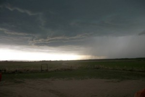
storm

Storm located north of Scottsbluff, NE.

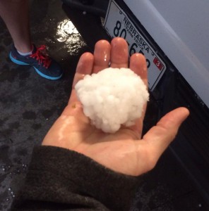
At the storms peak, we were located just north of Scottsburg. A severe thunderstorm warning had been issued on the cell and the road network north of Scottsburg was becoming quite scarce. The storm was heading due east toward us, and instead of ending the chase we decided to let the storm come over us. Hail was associated with the storm, therefore we had to seek shelter for ourselves and the van. We came across a local farmer’s garage, and after some persuasion the farmer let us seek shelter in his garage.

hail

Ball of hail from a storm located north of Scottsbluff, NE.

We experienced hail, high winds, and intense lightning. After the storm was over, we headed toward the southeastern edge of the storm. While on our way down, we encountered hail covered roads which looked similar to a snow covered road. We stopped one last time just outside of Scottsbluff to watch the storm and eat dinner. After this, we headed back to our initial target of Cheyenne, WY. We got to our hotel around 9:30pm.

Posted in Uncategorized | Comments Off on WKU Storm Chase Day 1

Upcoming Rain Chances

The weather has been stuck on repeat the past few days as we’ve seen day after day of sunny skies and warm to even hot temperatures in the mid 80s. While it feels a little for this time of year, it certainly beats the cold we became accustomed to this past winter and into the early spring.

We should see at least one more day of sunny skies and temperatures in the 80s… that being today. However, a low pressure system and cold front are approaching from the west. Overnight clouds should increase and by Friday morning our rain chances will be increasing dramatically. Scattered showers and thunderstorms are expected Friday into Friday night with this system.

92fwbgus

WPC surface analysis for Thursday afternoon. Note the approaching rainfall in association with the cold front and low pressure to our west. Meanwhile, high pressure remains in control for today.

Areas in western Kentucky have been placed under a “slight risk” for severe weather. This area includes locations along and west of a line extending from Hopkinsville to Owensboro. While south-central Kentucky isn’t included in this area, there could be a few strong to isolated severe thunderstorms with a primary threat of strong gusty winds.

SPC outlook for Friday includes a "slight risk" for severe thunderstorms just to our west.

SPC outlook for Friday includes a “slight risk” for severe thunderstorms just to our west.

Rainfall could be heavy at times, especially Friday afternoon. Overall rainfall totals should be in the 0.4″ to 0.8″ range through Saturday morning. A few more areas of upper-level disturbance will move through during Saturday and Sunday which will allow rain chances to continue through the weekend. Rain during the weekend should be far from a total washout though, possibly adding about 0.25″ to our total.

d13_fill

WPC expected rainfall through Sunday morning.

Looking longer range, rain chances will continue into early next week as another upper-level disturbance and associated low-pressure system and cold front approach.

Daily Forecast:

Today: Mostly Sunny with a high near 84. Clouds will increase into the afternoon. Breezy with southwest winds from 10-20 mph.

Thursday Night: Increasing clouds, becoming cloudy by morning. Low around 67. South-southwest winds at 3-9 mph.

Friday: 80% chance of scattered showers and thunderstorms. High near 77. Southwest winds from 10-20 mph.

Friday Night: 70% chance of scattered showers and thunderstorms. Low around 64. Rainfall totals (including Friday) between 0.4″ – 0.8″. Southwest winds at 6-12 mph.

Saturday: Mostly cloudy with a 40% chance of showers especially in the morning. High near 80. Southwest winds from 8-14 mph.

Saturday Night: Mostly cloudy with a 30% chance of showers. Low near 63. Southerly winds at 3-10 mph.

Sunday: 50% chance of scattered showers and thunderstorms. High around 82.

Sunday Night: Mostly cloudy with a 30% chance of showers and thunderstorms; low around 64.

Posted in Uncategorized | Comments Off on Upcoming Rain Chances

Sunshine & Warmth Prevails

We are coming off what has been a fantastic weekend weather-wise. Mostly sunny skies and high temperatures in the 70s and 80s have been the trend. This is as a result of the upper levels slowly transitioning from the upper-low we had parked over our area last week to a general ridging pattern. This riding pattern will continue as we move through midweek and thus sunny skies & warm temperatures can generally be expected.

A ridge pattern is often associated with surface high pressure which, in turn, can mean dry and warm weather. This will indeed be the case this week. In fact, the center of high pressure is currently over the northern parts of the Gulf of Mexico which allows warm-moist air to be filter into our region thanks to the clockwise flow around a high pressure. As a result 80s will be maintained through much of this week.

wpc_analy2

WPC Forecast Surface Analysis valid for 1 pm Monday.

That area of high pressure will slowly slide eastward into the eastern Atlantic and a low pressure system will take shape in the Great Plains. This setup will only enhance the southerly flow into the region.

Also, with the low pressure system still well to our west, conditions should stay dry through much of the week. Rain chances will not start to increase from the approaching system until Thursday Night and particularly Friday. Until then, enjoy an awesome streak of sunshine and 80 degree temperatures.

Daily Forecast:

Tonight: Mostly clear with a low around 55. South-southwest winds up to 8 mph.

Monday: Mostly sunny and warm with a high near 85. Breezy with a west-southwest wind at 10-20 mph with gusts up to 25+.

Monday Night: Mostly clear with a low around 57. South-southwest wind from 3-10 mph.

Tuesday: Mostly sunny skies and warm still yet with a high near 84. Southwest winds from 8-15 mph.

Tuesday Night: Mostly clear with a low around 57. South-southwest winds 3-8 mph.

Wednesday: Mostly sunny with a high around 85. Southwest winds from 8-15 mph.

Wednesday Night: Mostly clear with a low near 60.

Thursday: Mostly sunny and warm with a high near 85.

Posted in Uncategorized | Comments Off on Sunshine & Warmth Prevails

Beautiful Weather Ahead

Some areas of the country are sitting in shambles after the beginning of the week started with the first major outbreak of the year. The severe weather lasted a full two days and with it came a lot of devastation. The image below shows the preliminary tornado tracks as well as the number of casualties associated with each tornado. resultsTornadoes, hail, and wind damage weren’t the only types of severe weather seen early this week. Near Pensacola, FL, an approximated 15+ inches of rain fell in 24 hours creating flash flood conditions. This left many areas underwater and caused unprecedented damage.

However, after the shaky beginning of the week we can look forward to great weather for the next several days. An upper-level low will slowly make it’s way from the Midwest to the Great Lakes area leaving behind cooler air behind it, as we’ve felt today. The colder air aloft will result in skies being partly cloudy for the remainder of the day, with a slight chance of isolated showers towards the evening. The remainder of the week looks to be a fairly quite one for our region, even extending into the long range forecast area.

Weekly Outlook:

Today:Mostly sunny, with a high nearing 63. Winds will be out of the west around 15mph although a few gust could reach the mid-twenties.

Tonight:Partly cloudy, with a low around 43. West Wind 5-10mph.

Friday:Mostly sunny, with a high near 64. Winds will blow lightly in the morning hours around 8-13mph.

Friday Night:Partly cloudy, with a low near 45. Southwest wind near 7mph.

Saturday:Mostly sunny, with a high near 75. Southwest wind 6-11mph.

Saturday Night:Partly cloudy, with a low around 51.

Sunday:Mostly sunny, with a high near 81.

Sunday Night:Partly cloudy, with a low around 57.

Posted in Uncategorized | Comments Off on Beautiful Weather Ahead

Warm Weather and Severe Storms

We have a few rounds of showers and storms forecast to move through the area over the coming days. A few storms could even be severe early next week. However, today will be absolutely beautiful! The sun will be shining bright and we will warm to around 70 degrees this afternoon with hardly a cloud in the sky. Tomorrow will begin rather nice with clouds beginning to roll in early in the afternoon. The high temperature should still approach the upper 70s, but by tomorrow night, showers and a few storms look likely.

Expect a line of showers and storms tomorrow evening into the overnight hours. Any severe weather threat should remain to the west, however, there is a very slim chance that a weak squall line may trigger a warning or two in our area. Make sure you stay tuned to the weather tomorrow evening as the storms get closer to the region.The SPC has issued a slight risk for areas just to our west.

day2otlk_1730

Here is the NAM’s simulated reflectivity for tomorrow at 9pm.

namFLT_sfc_radar_039

The rain should not be particularly heavy except under thunderstorms. General rain amounts should be between .25 and .50 inches with slightly higher amounts in the heavier storms. The rain will move out early Friday morning which will leave us with another pretty nice afternoon.

Now lets talk about the sever potential early next week.

So far this year, the severe weather across the country has been quite non-existent and very few tornadoes have occurred across areas which typically see many during the spring.  Here is the day 4-8 severe storm outlook from the Storm Prediction Center:

day48prob

Five out of the next six days have at least a slight risk for severe weather across the country. Most of the threat will remain back across the Midwest, however, there is potential for severe weather in our area by Monday evening.

Overview of the Severe Potential:

This upcoming severe storm setup will likely lead to a large outbreak across the central U.S.  A deep, negatively tilted trough will move through the Midwest this weekend. The 250 mb map for late Saturday shows the trough exiting the Rockies into the southern Plains. The greatest severe potential Saturday will exist from Kansas down through central Texas.

namUS_250_spd_084

By Sunday the trough has pushed farther east, and along with it the severe storm potential. Sunday’s severe risk will include much of the area from Saturday but extends farther east as well to include central Missouri and Arkansas.

gfsUS_250_spd_108

As we head into Monday, the severe risk begins to include the our area. Severe potential exists from central Kentucky back to the west. As it looks now, the greatest severe potential will remain south and west of the Bowling Green area where supercells are more likely to develop. The cells will likely cluster and form a line as they draw closer to the Bowling Green area. BUT, keep in mind, this is 6 days out and no definitive forecast can be concluded upon.

What does it look like for our area??

Here is the location of the trough by Monday at 3pm

gfsUS_250_spd_129

The 500mb map at 6pm shows strong winds and vorticity in the area

500mb

vorticity

Jumping to the 700mb map at 6pm, vertical velocities over our area are rather strong. The vertical velocity map shows the areas where a parcel is most able to rise vertically.

700mb

The 850mb map shows the low level jet is cranking in our area at 6 pm with good, deep moisture streaming from the south.

6pm winds at 850mb

llj

850mb moisture at 3pm

gfsUS_850_dewp_129

GFS MUCAPE/Bulk shear map at 6pm shows MUCAPE values approaching 1500 J/kg just to our west, with strong bulk shear near 50 knots over Bowling Green. If the temperature can reach the upper 70s Monday, these values will likely be higher, adding a little more instability to the area.

mucape

The GFS surface Dewpoint at 6pm shows a dewpoint of 65 degrees just to our west at 6pm. This is more than sufficient moisture to help fuel any storms.

gfsFLT_sfc_dewp_132


While it is still too early to determine how high of a severe risk there will be in our area Monday, there is a potential for a few strong storms in our area and deserves attention. As mentioned earlier, the main severe weather threat in our area usually comes from a squall line. Storms to the west will likely form a line, with the main impacts being strong winds, heavy rain, some hail, and a few isolated tornadoes. The larger tornado threat looks to remain to the south and west at this time. However, the finer details are subject to change. More details will evolve as this system gets closer to the area. Make sure to keep an eye on the local weather this weekend for any changes with the timing and intensity of storms in the forecast.


Weekly Outlook:

Tonight: Mostly clear, with a low around 44. Northeast wind around 5 mph becoming calm in the evening.

Thursday: Sunny, then becoming mostly cloudy during the afternoon, with a high near 79. Light southeast wind becoming south 9 to 14 mph in the morning.

Thursday Night: Showers likely and possibly a thunderstorm between 8pm and 2am, then a chance of showers and thunderstorms after 2am. Mostly cloudy, with a low around 56. South wind 7 to 13 mph becoming west after midnight. Chance of precipitation is 70%. New rainfall amounts between a tenth and quarter of an inch, except higher amounts possible in thunderstorms.

Friday: A 30 percent chance of showers and thunderstorms before 8am. Sunny, with a high near 77. West wind 5 to 9 mph.

Friday Night: Mostly clear, with a low around 51.

Saturday: Sunny, with a high near 78.

Saturday Night: Partly cloudy, with a low around 53.

Sunday: A 40 percent chance of showers and thunderstorms. Partly sunny, with a high near 76.

Sunday Night: A 40 percent chance of showers and thunderstorms. Mostly cloudy, with a low around 59.

Monday: A 50 percent chance of showers and thunderstorms. Mostly cloudy, with a high near 74.

Monday Night: A 50 percent chance of showers and thunderstorms. Cloudy, with a low around 59.

Tuesday: A 50 percent chance of showers and thunderstorms. Mostly cloudy, with a high near 71.


Posted in Uncategorized | Comments Off on Warm Weather and Severe Storms

Sunshine and Blue Skies!

Happy Easter to all! Today will be part two of a beautiful weather weekend. The sunshine will persist throughout the day and the temperature will top out around 81 degrees this afternoon. Get outside and play some golf, head to a park, or fire up the grill, but don’t forget that sunscreen! imagesSome high clouds may try and move in from the west later this afternoon. Regardless, the sun will remain the dominant object in the sky.

A few showers will move into the area late Monday and into Tuesday. The high temperature tomorrow is dependent on how fast the clouds begin streaming in. Temperatures will likely approach the upper 70s to low 80s again tomorrow.  It won’t be an all day rain event, but some thunderstorms are a definite possibility. Another round of showers looks to move in by Friday. No severe weather is expected with any of these rounds of storms. However, the quiet severe weather pattern has started to amp up a bit in the Midwest. We will have to watch and see if that signals a more active pattern for our area over the coming weeks.

Here is the 5 day precipitation outlook:

p120iNot a whole lot of rain expected this week with any of the rounds of thunderstorms. Up to an inch is possible in Bowling Green. Slightly higher amounts may be possible under a heavy thunderstorm.

Overall, we can expect a lovely week with only a few minor rain chances. Get out and enjoy the weather. Before you know it, summer will be here and it will be too hot to play outside!

Weekly Outlook:

Tonight: Partly cloudy, with a low around 52. Calm wind becoming south around 5 mph after midnight.

Monday: A 20 percent chance of showers and thunderstorms after 4pm. Partly sunny, with a high near 79. Light southwest wind increasing to 5 to 10 mph in the morning.

Monday Night: A slight chance of showers and thunderstorms, then showers likely and possibly a thunderstorm after 7pm. Cloudy, with a low around 59. Southwest wind around 6 mph. Chance of precipitation is 60%. New rainfall amounts between a tenth and quarter of an inch, except higher amounts possible in thunderstorms.

Tuesday: A 30 percent chance of showers and thunderstorms before 1pm. Cloudy through mid morning, then gradual clearing, with a high near 72. West wind 6 to 13 mph becoming north in the afternoon.

Tuesday Night: Mostly clear, with a low around 45.

Wednesday: Sunny, with a high near 66.

Wednesday Night: Mostly clear, with a low around 46.

Thursday: Mostly sunny, with a high near 78.

Thursday Night: A 40 percent chance of showers and thunderstorms. Mostly cloudy, with a low around 57.

Friday: A 30 percent chance of showers and thunderstorms. Mostly sunny, with a high near 75.

Friday Night: A 20 percent chance of showers and thunderstorms. Partly cloudy, with a low around 53.

Saturday: Mostly sunny, with a high near 70.

Posted in Uncategorized | Comments Off on Sunshine and Blue Skies!

Excellent Easter Weekend

Discussion: After an early week chill, temperatures have warmed back to what is more typical for this time of year. We topped out in the upper 60s yesterday and it appears we should be in the 70s for the next several days.

Overall we are in a fairly quite spell. We have a very weak front in the region today which will for the most part go unnoticed. This surface feature will combine with a low pressure system in the Gulf of Mexico to bring in a few clouds today. Otherwise we’ll see sunny skies until Monday when the next system approaches.

Lows the next couple nights will be cool in the mid to upper 40s which is actually right around average for this time of year.

The string of tranquil weather days are thanks to an area of high pressure which will dominate our weather conditions through Monday. This should make for an excellent Easter weekend with highs in the 70s under sunny skies. This should make for some great egg hunts.

98fwbgus

WPC surface analysis for Easter Sunday puts south-central Kentucky in between two areas of high pressure which should make for a sunny day in the 70s.

The only other weather story worth mentioning will be an approaching system by Monday. We’ll see a broad area of low pressure in association with an upper level disturbance which should kick off a few showers/maybe a thunderstorm Monday afternoon into Monday night. The system is still too far out to mention rain totals, but it doesn’t look to be a wash out of any sort.

Come Tuesday, that disturbance will push east and early indications show that much of next week again will be nice with temperatures in the 70s with sunny skies.

Daily Forecasts:

Today: Partly sunny with a high near 70. Generally light winds.

Tonight: Clear and cool with a low near 47. Winds will be light to calm.

Saturday: Sunny with a high around 75. Easterly winds from 5-12 mph.

Saturday Night: Again, clear and cool yet again with a low around 47. Winds will be light to calm.

Easter Sunday: Sunny skies and warm with a high around 78. Light southerly winds generally less than 10 mph.

Sunday Night: Partly cloudy skies with a low near 57. South to southwest winds generally less than 10 mph.

Monday: Partly cloudy with a 40% chance of showers/thunderstorms, especially in the afternoon. High in the mid 70s.

Posted in Uncategorized | Comments Off on Excellent Easter Weekend

Winter’s Last Laugh (Hopefully)

Forecast Discussion: We’ve had a few showers move through this morning in advance of a cold front. Rainfall was generally less than 0.10″ east of I-65, while those west of I-65 picked up anywhere from 0.50″ to 1″.

For now the showers have moved out, however, the cold front is still off to our west, currently draped from southeast Indiana to roughly Memphis, TN and through parts of western Kentucky. As the front pushes through this afternoon, more scattered showers will develop along the front. No worries of severe weather today, but a rumble of thunder cannot be ruled out.

A very strong upper-level piece of energy will move into our region this evening which will enhance our rain chances along and even behind the front. Thus, despite the cold frontal passage this afternoon, rain chances will continue overnight. Showers will likely even become quite widespread across the area. We could see 0.25″ – 0.75+” of additional rainfall from this evening into Tuesday morning.

1ref_t6sfc_f12

RAP simulated reflectivity valid for 9pm Monday.

A sharp temperature decline will also be noticed behind the front. Temperatures will fall into the 50s by this evening. Overnight, temperatures will fall through the 40s before bottoming out in the mid 30s. Winds will be quite breezy along and behind the front as well. Northwest winds at 10-20 mph with gusts up to 30+ mph are possible.

As a result of colder temperatures and lingering moisture, there could even be a few flakes flying come Tuesday morning as the precipitation ends. A harsh stubborn winter just won’t give in.

Everything calms down as we move into the midweek time frame. High pressure will works in way in by Tuesday afternoon/night which will allow skies to clear. It will also aid in bringing in cold temperatures. Highs on Tuesday will only be in the 40s and by Wednesday morning, lows are expected to drop into the upper 20s. A hard freeze is likely (A Freeze Watch as already been issued for Tues Night/Wed morning), thus precautions should be taken with any sensitive outdoor vegetation.

aprilfreezhigh_nam

Surface analysis of NAM model valid for 4am Wednesday.

Southerly winds will return for Wednesday and Thursday with the “return flow” around the high pressure. This along with mostly sunny to sunny skies will allow temperatures to moderate once again. We won’t see 80s again, but at least a return to 60s is expected. The next rain-maker is poised to move in on Friday.

Daily Forecasts:

This Afternoon: Mostly Cloudy with a 50% chance of scattered showers. High near 70. Breezy with southerly winds from 10-20 mph through early afternoon becoming northwesterly at 10-20 mph this evening.

Tonight: 80% chance of rain; a few snow flakes could mix in toward morning. Additional rainfall totals will range from 0.25″ to 0.75″ by Tues morning. Windy and turning colder with temperatures falling through 40s, bottoming out near a low of 35. Winds will be from the northwest at 10-20 mph with gusts up to 30+ mph possible.

Tuesday: Cold with a high only around 48. Clouds and a 30% chance of rain/snow showers will start the day. Clouds will decrease throughout the day and skies will become mostly sunny by the afternoon. Still breezy with north winds at 10-20 mph.

Tuesday Night: Freeze Watch. Cold with a low near 28. Skies will be clear and winds will become calm. A hard freeze is likely thus precautions should be taken to protect and outdoor sensitive vegetation.

Wednesday: AM Freeze Watch. After a cold start, temperatures will warm to around 60 under mostly sunny skies. Southeast to south winds at 5-12 mph are expected.

Wednesday Night: Mostly clear skies and again quite chilly with a low around 34. Generally light winds.

Thursday: Mostly sunny with highs in the mid to upper 60s.

Posted in Uncategorized | Comments Off on Winter’s Last Laugh (Hopefully)

Beautiful, Breezy Day

What a beautiful and sunny day for our area! The Kentucky Mesonet has Bowling Green currently sitting at 73 degrees and the sunny skies have helped the temperature get there. Mostly clear skies will continue through today until the cold front approaching from the northwest gets closer. As the front approaches it will start to stall and slowly sink southward through tomorrow. Ahead of this front expect to see scattered showers with the chance of a few isolated thunderstorms. Although severe weather is not expected due to the lack of instability. Expected rainfall amounts are estimated to stay below an quarter of an inch for the next two days.QPF

Showers will taper off into Friday night leading into a nice weekend for us all, although a few showers Saturday can’t be ruled out. Saturday and Sunday for the most part will be days full of partly cloud skies and temperatures in the mid to upper 70’s. However the sunshine will be taken over by a new developing low pressure system that is developing in the OK/TX panhandles. Sunday night showers will move back into the region.


Weekly Outlook:

Today: Sunny, with a high near 76. Windy, with a south wind 20-22 mph, gust could reach as high as 32.

Tonight: Isolated showers and thunderstorms after 2am. Partly cloudy, with a low around 54. South wind 8-15 mph. Chance of precipitation is 20%.

Friday: Mostly cloudy, with scattered showers and thunderstorms. High will near 71. Southwest wind 7-11 mph. Chance of precipitation is 50%.

Friday Night: Mostly cloudy, low near 52. Chance of showers, mainly before 9pm at a 30% chance.

Saturday: Partly sunny, with a high near 75. Light south wind will increase to 10-15 mph in the morning.

Saturday night: Partly cloudy, with a low near 59.

Sunday: Partly sunny, with a high near 79.

Sunday Night: Mostly cloudy, with a low around 62. Chance of precipitation is 50%.

Monday: Cloudy, with a high near 67. Showers are likely with possibility of stray thunderstorms. Chance of precipitation is 70%.

Monday Night: Mostly cloudy, with a  low around 37. Chance of showers. Chance of precipitation is 40%.

Posted in Uncategorized | Comments Off on Beautiful, Breezy Day

Drizzle Drizzle

Looks as though today is going to continue to be a yucky day accompanied with the occasional drizzle. Clouds will continue to linger as the low-pressure system continues to track out of our area. A shortwave trough is tracking through the midwest behind this departing low and with that will come isolated showers and thunderstorms throughout the day. Some of the stronger cells could produce small hail or graupel but any other severe weather threats are minuscule. As the sunsets expect convection to diminish and the chance of precipitation tonight to diminish with it. High temperatures today will reach the upper 50’s to lower 60’s. As clouds clear tonight lows will fall to the lower 40’s to upper 30’s. Wednesday is looking to be a sunny but cool day with a high temperature in the lower 60’s. High pressure will begin to settle into the southeast. This high pressure will keep Wednesday and Thursday dry but winds will pick up Thursday into the night as a front approaches from the northwest. The front is expected to stall out over central Kentucky and with it we should see scattered showers and thunderstorms Thursday night into Friday morning.

Weekly Outlook:

Today: Scattered showers and thunderstorms with a 60% chance of precipitation. West wind 6 to 9mph. High today will near 62.

Tonight: Chance of showers before 9pm but a gradual clearing of clouds expected after midnight. Low tonight will fall to around 38.

Wednesday: Sunny skies, with a high nearing 65 accompanied by a northwest wind at 5 to 8mph.

Wednesday night: Mostly clear, with a low around 40. West wind around 5mph becoming south after midnight.

Thursday: Sunny, with a high near 73. South wind from 6 to 11mph increasing to 12 to 17mph by afternoon. Gust could reach 28mph.

Thursday night: Mostly cloudy, with a low around 52.

Friday: Mostly cloudy, with a high near 71. Chance of precipitation is 30%.

Friday night: Mostly cloudy, with a low near 51. Chance of precipitation is 30%.

Saturday: Partly sunny, with a high near 74.

Saturday night: partly cloudy, with a low around 57.

Posted in Uncategorized | Comments Off on Drizzle Drizzle