After a rather warm week, today is going to be quite a shock to the system. Today you can expect much cooler temperature with highs in the upper 30s and lows tonight in the low 20s. At least today will be drier than yesterday!
What to Watch For
For your weekend you can expect a rebound in temperatures. Saturday will be cloudy, but temperature will rise into the lower 50s. Overnight, temperature cool into the mid 30s with clearing skies. For Sunday, highs will push 60 and skies will be clear. Enjoy the improved weather this weekend! Looking ahead to next week, temperatures will warm back into the 70s by mid week, but it comes at the expense of increased rain chances.
Weather Fact!
Yesterday here in Bowling Green was a soaker! Yesterday’s 24-hour rain total of 1.95″ was the most so far this year, and the greatest total since August 28th, 2022 when we saw 2.04″ of rain. (KY Mesonet)
Good morning, and happy Wednesday! I hope everyone is having a great week so far and getting prepared for some possible severe weather. As the wind advisory expired early this morning, that is not the last we will see of the wind, rain, and storms. Today will be unseasonably warm with a high of 76 and a low of 62. We can expect a breezy and mostly cloudy day with some sun shining through occasionally. As we go into late Wednesday night/early morning Thursday, we can see some showers and thunderstorms start to pick up. These storms will continue throughout the day until sometime Thursday afternoon. A few storms may be strong to severe with chances of heavy rain, gusty winds, and even some chances for hail. A first alert weather day has been declared for Thursday. Temperatures start out warm, but as the storm passes through temperatures will drop to the lower 40s and 30s.
Recent Wild Weather
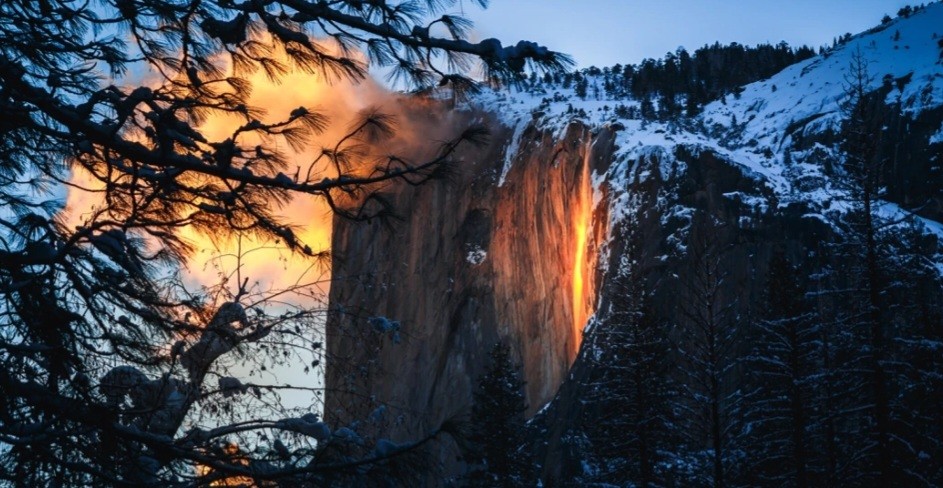
This week begins peak season for Yosemite National Park’s famous firefall to be seen in all its glory. Each year from mid to late February Horsetail Fall, sitting at 1,575 feet in the Yosemite Valley, takes on the look of a fiery waterfall. What causes this phenomenon you may ask? When the setting sun hits the waterfall at just the right angle, it gives the illusion that the waterfall is on fire. However, this isn’t the only condition that has to be met in order for this to occur. The weather must be in full cooperation. In addition to the sun’s angle being perfect, you will also need the sky to be absolutely clear to make way for the sun to come in and hit the water. You will also need a significant amount of precipitation to give the waterfall good flow. Luckily, 2023 has brought record breaking amounts of snow and rain to California. It’s the perfect setup to get this “firefall” glowing! It has become such a popular event for nature lovers and photographers that reservations are now being required. This year’s peak dates for viewing this phenomenon are February 10th-27th with a viewing time between 5:00 p.m. and 6:00 p.m. as the sun is setting. Park temperatures this time of the year in Yosemite average between 28°-53°.
Wild Weather this Day in History
Well, snow, snow, and more snow! So, instead I’d like to take this moment to recognize one of the greatest astronomers, physicist, and engineers to ever live! Galileo di Vincenzo Bonaiuti de’ Galilei (commonly referred to, simply as, Galileo) was born on this day in history, February 15th, 1564. Galileo was an Italian mastermind, responsible for many discoveries and inventions that helped propel the scientific world forward. Among the many inventions he is responsible for, he invented the thermoscope, now the modern thermometer. Galileo’s original design was a device that could show changes in temperature in a liquid-filled tube. The different liquids rise and fall as the temperature changes. These thermoscopes have once again become popular, and you may have seen on and didn’t even realize it. Happy birthday Galileo!
Have an amazing rest of the week, and make sure to stay up to date with your latest weather conditions!
Happy Monday and happy Valentine’s Day! I hope you remembered a gift for that special someone, and for everyone else, we get a gift of warmer temperatures! This also might be a good time to go watch, “Forecasting Love and Weather” on Netflix. I hear good things about it but I haven’t gotten around to watching it yet. Now on to the forecast.
A Wind Advisory is in effect from 7pm Tuesday until 7am Wednesday for wind gusts up to 50mph possible.
Monday Night: A low of 37 degrees with partly cloudy skies.
Tuesday: A cloudy day with a high of around 66 degrees. Winds are 10-20mph with gusts up to 40mph, so bring in those small items.
Tuesday Night: The wind does not die down during the night. Scattered rain showers in the evening before becoming partly cloudy overnight.
After a crazy windy day yesterday, you can expect calmer conditions for your Friday. High temperatures today will top out around 50, as winds diminish greatly from yesterday. For tonight, partial clearing will occur allowing for temperatures to drop into the upper 20s.
What to Watch For
Sunny skies and temperatures in the 50s will tell the story of this weekend’s weather, as only a slight chance of showers exists for Saturday night. Enjoy the mild and relatively calm weekend! Looking ahead to next week, temperatures will continue to warm throughout the week, even pushing 70 by Wednesday. We will keep an eye on rain chances for you Tuesday as well.
Weather Fact!
Yesterday in Bowling Green was the windiest day by average wind speed since March 30th, 2022. With an average wind speed of 17.8mph yesterday, it is the windiest day of 2023 so far. Looking back to 2022, only one other time (besides March 30th) was there a windier day, where on February 17th the average winds were 19.6 mph. (KY Mesonet)
Hopefully that is all for the strong winds this year, I almost lost my hat yesterday!! Have a great weekend everyone 🙂
Good morning and happy Wednesday! I hope you are having a great week so far and finally enjoying some warmer weather. As we go into today, make sure you grab your rain jacket on the way out! Today will be mild with rain, some of which could be heavy, throughout the day. Temperatures will stay in the 50s and 60s with calm winds. Going into early morning Thursday, we will see the wind and rain pick up, but eventually die back down around 7-8 am. The remainder of Thursday will stay in the 50s and 60s with gusty winds before cooling off later into the night.
Recent Wild Weather
Have you ever witnessed a loud boom that sometimes comes with slight shaking in the middle of Winter? If you have, you may have experienced what is known as an ice quake, also known as cryoseism. This is a seismic event that is caused by sudden drops in temperature where the ground goes from wet to frozen. When the water underneath the ground continues to freeze, it expands and applies pressure on the soil until the ground begins to crack frost and/or ice. Sometimes, when the frost or ice cracks, it causes a loud boom to be heard and sometimes even shaking occurs, replicating an earthquake. With the recent cold blast of air in parts of New England, specifically New Hampshire, these ice quakes have been reported of happening.
Wild Weather this Day in History
34 years ago, on February 8th 1989, a freak snow storm struck Los Angeles, California. This snow storm came with howling winds and temps below zero, along with the threat to crops and causing major freeways and schools to shut down all the way from the beaches of Malibu to the desert around Palm Springs. Different locations throughout California saw anywhere from 6 to 16 inches of snow. At least one death was associated with the cold and another was caused by a wreck from frozen roads. This storm was caused due to an upper level low pressure system off the coast mixing with an “Arctic Express” high pressure system that had settled over the Rockies. The National Weather Service issued many different snow advisories and winter storm warnings, as an end to this storm was not predicted.
Have an amazing rest of the week, and try to stay dry!
Happy Monday everyone! Did anyone watch the new and improved Pro Bowl games? On Groundhogs Days, Phil saw his shadow Thursday morning after leaving his burrow in Punxsutawney. That means the country can expect below-average temperatures for the next six weeks if you believe the legend of Phil’s weather-predicting abilities. Anyways enough of the long-term weather, what is the forecast for the next few days?
Monday Night: Partly cloudy as more clouds move in. Low of 46 degrees.
Tuesday: Cloudy all day with a chance of some rain showers. High of 65 degrees and winds 10 to 20mph.
Tuesday Night: Cloudy all night with a low of around 47 degrees.
We can expect these warmer temperatures to stay around for at least the short and rain returns on Wednesday, but no snow in the foreseeable future.
Today is going to provide a taste of winter that has been few and far between so far this season. High temperatures will struggle to get above freezing with mostly cloudy skies. Tonight, temperatures will plummet into the upper teens. Make sure to bundle up if you are heading out!
What to Watch for
This weekend will begin a warming trend that will last through next week, as highs in the upper 40s on Saturday and mid 50s on Sunday prepare us for 60s in the forecast next week. Peeks of sunshine will also be possible this weekend, as it is shaping up to be a rather nice and calm weekend weather-wise. Get out there and enjoy it before the middle of next week, where rain chances will rise.
Weather Fact!
Do you think that it is cold here? Wait until you here about the cold in Mount Washington, New Hampshire! The 6,288 foot peak is no stranger to cold and windy conditions, however yesterday’s cold set a record for coldest windchill recorded. Air temperature in the -40s and winds gusting over 100mph combined to create a wind chill reading of -108 degrees! It is hard to even imagine how cold that would feel!
Luckily, none of that “The Day After Tomorrow”-like weather is in our forecast! Have a great week everyone 🙂
Good morning, and happy Wednesday! It’s crazy to believe it is already February! It feels like just yesterday we were celebrating the New Year. As we come out of a winter weather advisory, icy conditions are still expected. Temperatures will stay below freezing until late morning, but warm up to the upper 30s by this afternoon with sun and clouds expected. With that being said, any icy spots could remain in areas that get little to no sunshine, so be cautious as you travel throughout the day. Thursday will be mostly cloudy with a very slight chance of a wintery mix in the morning with a high of 42 and a low of 24.
Recent Wild Weather
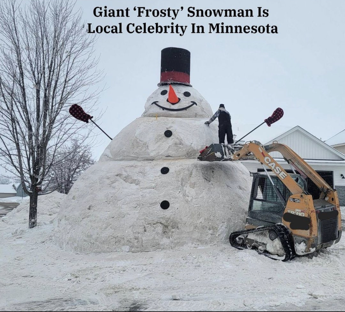
With recent heavy amounts of snow the past couple of weeks, a family in Buffalo, Minnesota has been working on something big. With the help of friends, neighbors, and snow plows, the Fobbe family decided to make a giant “Frosty”. Being 30 feet tall and 20 feet wide, this giant snowman nearly takes up their entire front yard. This is the fourth year in a row that this family has built “Frosty”. As temperatures rise above freezing, they add as much remaining snow as possible to keep the giant snowman from melting. This year, they are using Frosty’s attention in hopes to collect donations for a friend who has cancer.
Wild Weather this Day in History
As many of us anticipate to see if Phil will see his shadow or not, let’s go back 12 years to what is now known as the Groundhog Day Blizzard. On Monday, January 31, 2011 a very powerful low pressure system produced blizzard conditions across southern Wisconsin. January 31 through mid-day February 1, several inches of snow hit the southern area. Strong winds and light lake effect snow was associated with this system. By Tuesday evening through Wednesday morning (Groundhog Day), things really started to amp up. Over the three day period, a total of 18.7 inches of snow fell. 8.3 inches falling just on February 1, breaking the daily snowfall record. Along with becoming the fifth highest snowfall amount in 48 hours between that Tuesday night and Wednesday morning with a total of 14.3 inches. Despite these conditions southern Wisconsin faced, Phil did not see his shadow that Wednesday morning, predicting an early Spring.
Continue to stay warm, and have a great rest of the week!
Happy Monday everyone! I hope you had a good Monday because these next few days might be a bit icy. So remember to keep some extra space between you and the car in front of you when driving on icy roads.
Tonight: Rain transitioning over to a wintry mix. Low of around 30 degrees and ice accumulations of up to 0.25in. Watch out for black ice!
Tuesday: Overcast all day with a chance of flurries. High of around 36 degrees.
Tuesday Night: Mainly cloudy with possible snow showers late in the night. Low of around 27 degrees. Also, happy Feburary!
For today, you can expect a bit of a warmup after a couple of chilly days. Thanks to a steady wind out of the south, highs will top out in the low 50s with full sunshine. A great day to get outdoors for sure! Lows tonight will drop into the mid 30s as a few clouds build in overnight.
What to Watch For
This weekend continues Friday’s trend of steady winds and warmer temperatures. For Saturday, highs will push 60 with mostly sunny skies. However, Saturday night rain chances increase as temperatures drop into the mid 40s. These rain showers will persist into Sunday as temperature top out right around 50. Next week we are monitoring the chance for some winter weather, however precipitation types and amounts are not certain as of now. Stay tuned to the local forecast for updates for the middle of next week and how winter weather could impact the area.
Weather Fact!
It is no secret that this January has been warmer than usual, in fact, the average temperature for the month is a balmy 43.8 degrees. With four days left in the month, and three days of temperatures forecasted to be in the 50s, it is safe to say that this could be one of our warmest Januaries ever in the region. Since the Kentucky Mesonet’s earliest record of monthly summary data, in 2008, the warmest January average temperature was in 43.1 degrees in 2017. For perspective, last January’s average temperature was 32.5 degrees. (Kentucky Mesonet)
For the winter haters, this year has been rather kind to you! For my fellow snow-lovers, well, lets wait and see what happens next week! 🙂