squall line of thunderstorms tonight

Eventhough the spc does have a severe thunderstorm watch for our area, a band of strong to severe storms has formed across western kentucky this evening and will move toward the Bowling Green area between 8 and 10 pm tonight. The main threat will be for gusty winds in our region from the thunderstorms. I’ll pass along any warnings tonight.

Posted in Kentucky Weather | Comments Off on squall line of thunderstorms tonight

scattered storms and high heat index values

outside of any scattered storms this weekend will continue to be hot and humid with highs in the low 90’s and dewpoints in the 70’s making it feel near or over 100. allow extra caution if outdoors.

Posted in Kentucky Weather | Comments Off on scattered storms and high heat index values

high heat index values today (6/11/10)

heat index values both at the mesonet site and at the airport have been running in the 95-100 range this afternoon. This is thanks in large part to a very moist atmosphere( dewpoints in the mid 70’s) and temps getting close to 90. should the region not see any pop up storms today heat index values by late afternoon could easily top 100. excercise caution if you have to be outside for long periods today.

Posted in Kentucky Weather | Comments Off on high heat index values today (6/11/10)

Rainfall record 6/4/10

Updated weekend forecast 6/9/10

1. Leftovers of the front dying out over the region today will lift northward throughout the week allowing for more muggy and hot air to stream back north into our region. However this will allow for a chance for pop up afternoon storms as well. These storms may produce locally hvy rains. I expect highs to be near 90 or in the low 90’s  throughout the region each day through Saturday.

2. By Sunday and Monday the next cold front approaches with a higher chance of storms and slightly cooler weather by Sunday night.


this from the nws….

RECORD EVENT REPORT
NATIONAL WEATHER SERVICE LOUISVILLE KY
532 PM EDT FRI JUN 4 2010

…RECORD DAILY MAXIMUM RAINFALL SET AT BOWLING GREEN…

A RECORD DAILY RAINFALL OF 2.54 INCHES WAS SET AT BOWLING GREEN
TODAY. THE OLD RECORD OF 2.15 INCHES WAS SET IN 1893. TODAYS RAIN
FELL IN ONLY ONE HOUR AND 20 MINUTES TIME.

It’s just Ironic an update is needed only hours after issuing a two week forecast, which is still below on the last post. This further lessens the chance of a late summer drought.

Posted in Kentucky Weather | 2 Comments

14 day forecast

Here is an overview of the expected weather the next two weeks. If severe weather is expected ( most likely middle of next week if at all) or the tropics become more active another update may be needed before the end of this forecast. Also you can scroll down to previous posts on my summer forecast and a recap of the field methods class tracking storms in the plains.

Sat Jun 5- isolated (30%) lo 68 hi 92

Sun Jun 6- scattered (50%) lo 69 hi 88

Mon Jun 7- isolated (30%) lo 65 hi 86

Tue Jun 8, Wed Jun 9, Thu Jun 10- mcs complex chances, scattered (50%) lows mid 60′s highs mid 80′s.

Fri Jun 11- fair lo 66 hi 89

Sat Jun 12- hot lo 67 hi 91

Sun Jun 13- hot low 71 hi 95 ( heat index:100)

Mon Jun 14- hot lo 73 hi 95( heat index: 100)

Tue Jun 15- fair lo 73 hi 91

Wed Jun 16- isolated (30%) lo 71 hi 87

Thu Jun 17- isolated (30%) lo 68 hi 85

Fri Jun 18- fair lo 67 hi 87

Sat Jun 19- fair lo 68 hi 87

Posted in Kentucky Weather | 4 Comments

another day another severe thunderstorm watch till 8pm

The same frontal boundary which has been in place since Wednesday will again be the trigger for scattered to numerous thunderstorms late this afternoon and evening. LI values are in the extremely unstable range near -10 just east of Bowling green  and cape values near 3000 which are even more favorable for severe weather than they were Wednesday. Any storms that develop today although more scattered than Wednesday  will have the threat to produce hail and gusty winds across the region.

Spc discussion:

DISCUSSION…THUNDERSTORMS HAVE DEVELOPED ALONG A ZONE OF WEAK
   CONVERGENCE IN NERN AR/WRN TN AND ARE EXPECTED TO DEVELOP NEWD INTO
   SRN KY. STRONG INSTABILITY COMBINED WITH STRONGER WINDS ALOFT WILL
   LIKELY RESULT IN STORMS WITH SEVERE HAIL…LOCALIZED DOWNBURSTS AND
   HEAVY RAINFALL.

link to radar

http://radar.weather.gov/Conus/centgrtlakes.php

I’ll pass along any warnings or thoughts in the comments section

Posted in Kentucky Weather | Comments Off on another day another severe thunderstorm watch till 8pm

severe thunderstorm watch till 8 pm

The second mcs to our northwest has refired this afternoon to produce numerous thunderstorms just to the northwest of our region. These storms are developing rapidly this afternoon and will continue to slowly move southeast into the Bowling Green area by early evening. Large hail, gusty winds and hvy rains are possible with these cells. The best chances will be from 4 and 7 pm ct for storms.

radar

http://radar.weather.gov/Conus/centgrtlakes_loop.php

spc discussion

   DISCUSSION…WITH A VERY UNSTABLE AND VIRTUALLY UNCAPPED AIR MASS
   ACROSS THE WATCH AREA…THUNDERSTORMS ARE INCREASING RAPIDLY IN
   INTENSITY AND NUMBER. WITH ONLY 20-30 KT OF SHEAR…PULSE SEVERE IS
   PRIMARY THREAT INCLUDING LARGE HAIL AND DAMAGING DOWNBURST WINDS.
  

I’ll have more in the comments section as these storms move closer.

Posted in Kentucky Weather | 3 Comments

Thunderstorms staying north so far

Our mcs thunderstorm complex worth watching dissipated overnight but is still bringing some thunderstorms to northernKentucky this morning. This boundary should stay north of Bowling Green today which means we’ll have to wait fro the next mcs along the same front to bring a chance for some storms. The second mcs to form along the front is over central Missouri now, right now I’d have to say it is less intense severe wise than the first one was last night and will likely weaken this morning as it moves east into the Missouri valley. Eventually this complex may strengthen do to the heat of the day and a moderate to large degree of instability, cape from 700-2700 and a  LI from -4 to -6 modeled  over the mid south and lower Ohio valley this afternoon and evening thus the storm prediction center has a slight risk for severe storms just to the north of BowlingGreen. The chances for severe weather today through Thursday will be closely monitored here and by the stormtoppers, please check back for more updates.

Posted in Kentucky Weather | Comments Off on Thunderstorms staying north so far

Overnight derecho worth watching

A large complex of severe storms has formed to our north and west with numerous warnings for large hail and 70 mph winds. Thunderstorm complexs like this one are fast movers and can cover a lot of area in just 10 hours or so. This complex is moving to the east and southeast about 50 mph and is currently over northern Missouri. I think this has a shot of making into Kentucky around or shortly after dawn. This thunderstorm complex will likely weaken some but still could produce hvy rains, gusty winds near severe levels and hail. As of now I would say we have a 45% chance of being impacted by this thunderstorm complex for the morning rush.

radars

Upper Mississippi Valley sector loop

Central Great Lakes sector loop

check out the stormtoppers site for overnight updates.

Posted in Kentucky Weather | Comments Off on Overnight derecho worth watching

2010 Summer & Hurricane Forecast

Write-up is for Kentucky, maps are national based.

First let’s take a look at the analogs, past years that had similar conditions to this one heading into the summer. 

2007, 2005, 1998 and 1995.

– 2007 featured a very dry may around here but was a good match with the enso state the same can be said with 2005. 1998 and 1995 featured wet months of May. There two things in common with all 4 years, very hot months of August and very active hurricane seasons. Those will be the highlights of this summer.

June -short-term modeling other than the US model, the CFS indicates ridging from the southern plains will make a run or two throughout the month at the lower Ohio valley leading to a threat of a short heat wave or two by mid to late June. At the same time several strong frontal system should give  the great lakes and northeast  some refreshing Canadian air from time to time. There will a be an almost constant battleground which will near our area for the month which means there will be higher than normal thunderstorm activity. Several severe events are likely some in the variety of squall lines others are mcs events along warm or stalled fronts. Overall expect June to be slightly warmer than average and wetter than normal.

July- I expect July to be about a normal month of July for the region both in terms of precipitation and temperature. Although normal will be the sum at the end variability should still be expected.

August -All four of the analog years had a very hot with august with readings near 100 many days in 2007 but that was very dry as well, so it’s not likely to get that hot (6* above normal) but above normal temperatures are likely with several heat waves. With the potential to be in the main ridge of heat by August precipitation frequency should decrease somewhat as well which may favor  below average precipitation.

Tropics

– again all 4 of the analogs had very active tropical seasons in the atlantic with 2005 being the #1 season on record.

– the tropical waters from the gulf to the Caribbean are very warm for this time of year

– the euro seasonal model has continued to indicate for several months below normal pressures for the tropical season in the gulf, Caribbean and atlantic off africa.

my forecast

– 16 to 21 named storms

– 9 to 11 will be hurricanes

– 3 to 6  will be major hurricanes

MAPS

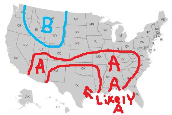
nationwide temperatures summer 2010

Overall there should be some cool weather over the northern Rockies. The main ridge of heat should be over the southern plains and flex northeast from time to time particularly in June and August. Regions not highlighted are near normal in terms of temperatures.

precipitation summer 2010 compared to normal

Above normal precipitation is indicated in the southeast due to tropical activity and below normal under the heat ridge in the southwest away from the monsoon. Another area of above normal precipiation will be present with the ring of fire pattern and battleground to the north of the heat ridge.

Hurricane tracks 2010

the southern plains ridge should lead to one track into Mexico. Other tracks should be from the central and eastern gulf northeast with another track where storms may come close to the east coast.

Kentucky recap

Temps- slightly above normal ( warmest to normal in mid to late June and August)

Precip- near normal

For more on your state or location feel free to comment or send a facebook message to me (Mitchell Gaines city: Bowling Green, KY) I’ll be glad to answer any of your questions.

Posted in Kentucky Weather | Comments Off on 2010 Summer & Hurricane Forecast