May 21st recap and update on the field methods class in the plains

We start one week ago yesterday (May 21st),  their second day out covering storms,  we had our own event here in Kentucky. Enough instability more than what was predicted  allowed  thunderstorms to develop along a week warm front and a cold front further west. These storms  developed into supercells near the warm front positioned over the bluegrass by Friday evening. These supercells were scattered but produced hail to the size of golfballs, numerous reports of wall clouds and also had multiple signs of rotation on radar prompting several tornado warnings. Along the cold front a squall line of thunderstorms developed from Bowling Green to Louisville with gusty winds from 35-65 mph in most cases, there was one tornado touchdown near Elizabethtown. Kentucky had them beat for now in terms of severe weather, this would not last long similar to any lead any 16 seed gets in a ncaa tourney game.

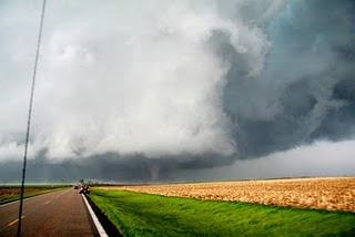
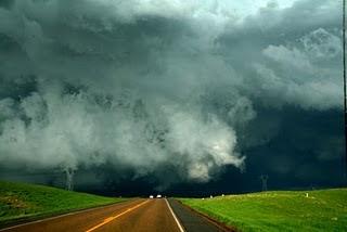
Later that day they our storm team in the plains caught up with a supercell near the WY/NE border and tracked this storm for several hours that did produce a tornado which was missed but they saw some funnel clouds and wall clouds. The next day several tornadoes were observed as they tracked a storm from the inital formation. In order to do this the forecast thinking for the day had to be dead on with where storms would develop and this was the case. Here is there forecast map for May 22nd.
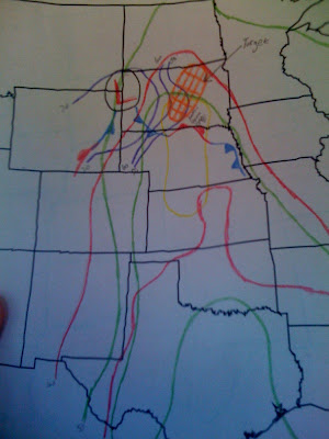
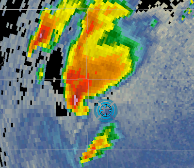
Cape which is an indicator of atmospheric instability was over 5000 J/KG so the storms that fired had the potential to be explosive. After the formation of the storm they set-up just southeast of the hook where tornadoes most often occur with supercells.

radar of the storm
Tornado pics

sky is getting a little dark on the last one, wow!

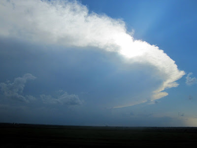
On May 23rd the group went south where more severe storms were expected. The first cell they tracked two cells, the first they were able to capture the classic structure of this storm. The second storm they set-up about 15 miles away and saw another tornado.

cell 1
cell 2
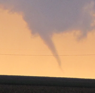
On May 24th the SPC had a moderate risk for a large portion of the plains. However storms were moving very quick, to quick to track. They went back and forth between storms but were not able to really lock on to any particular storm like the previous few days but they did get to see how a squall line is structured.

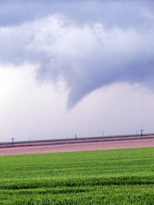
May 25th was a much better day in Nebraska this time tracking a cell from 4:30 to 10:30 pm local time getting once again non the southeast side of the storm to avoid the hail core. With this storm they saw a tornado touchdown first hand and saw a total of 5 tornadoes from this storm!!!

initial funnel
touchdown
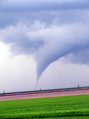
At first they were over 5 miles away but got within 2 miles of another tornado!!

On May 26th the storm team saw the same thing I did and posted that day the observation from the Denver international airport of a funnel cloud so of course that is the area they are near that day. This cell produced more funnels but no touchdowns likely due to the higher elevations and drier airmass.

The last few days have been a bust so far but I don’t think there complaining after the fast start they had. Looking back those stuck in KY as the 16 seed are now 100 points behind in that game after an interesting May 21st and I for one hope to be able to switch spots next year.

Looking at this weekend there is a slight risk of severe storms Saturday over the northern plains and Monday, memorial day in Kansas with a day 4 risk in the northern plains. For us in Kentucky we have to watch this very same front by the middle of next week to see if a mcs complex can dive southeast into the lower Ohio valley and produce severe weather around here. For this weekend weatherwise we’ll have isolated storms sat-sun then increase the coverage to scattered on memorial day as a weak cold front gets closer.

Our eyes also should be turned to tropics a bit as well with the Canadian model bringing a tropical storm into Tampa bay and taking its leftovers into eastern Kentucky for June 2nd-4th.

the gfs has this feature to some extent as well, we’ll see not biting untill the euro starts to show it as well.

– all the photos are from the wku storm group and are not mine.

link to track the group across the plains.

http://people.wku.edu/michael.grogan/FieldMethods/

Posted in Kentucky Weather | Comments Off on May 21st recap and update on the field methods class in the plains

Info to follow our WKU field methods class as they track storms in the plains

Over the next two weeks this class of WKU met students will track storms across the great plains and you can follow along using the links below. Not much in terms of hazardous weather is expected soon so I will leave this post up and we can sit back and follow there journey. By early next week chances for severe weather could increase in Nebraska and South Dakota.

Go to http://www.spotternetwork.org/feeds/grlevelx.txtUse your browser’s find function (click ‘Edit’ and then click ‘Find on this page’ on the dropdown menu or type Ctrl+F) and type in Grady Dixon or Josh Durkee (I would probably use Grady Dixon as I don’t know if Dr. Durkee is set up to be tracked yet but I know Dr. Dixon is). When you find him, the line above his name will have a set of 2 numbers. These are the latitude and longitude coordinates. Go to http://www.gorissen.info/Pierre/maps/googleMapLocation.phpand under ‘Coordinates’ type the lat and lon to find our location. And of course, go to http://www.nws.noaa.gov/ and click on our location to bring up the nearest NWS office. There should be a link for radar on the left side of each office’s page. Click on that and see if we are on some storms. Also, go to http://fastforecast.blogspot.com/. This is a blog of one of the people on the trip and we will all be updating it daily.

Posted in Kentucky Weather | 3 Comments

Scattered showers and storms for the weekend…

Boundary related to the low pressure center along the Ohio River will push south, providing lift to create some nice thunderstorms today. Continue reading
Posted in Kentucky Weather | Comments Off on Scattered showers and storms for the weekend…

Hit and Miss…

The pattern doesn’t seem to be changing much, with several pieces of energy traveling through the longwave trof, keeping slight chances of precipitation for the area through much of remaining work week. Continue reading
Posted in Kentucky Weather | Comments Off on Hit and Miss…

Next system progressing our way…

High pressure has dominated much of the weekend. With dry Continue reading

Posted in Kentucky Weather | Comments Off on Next system progressing our way…

Shot at storms tonight

Tonight the Mid-South has the potential of seeing some thunderstorms, a few of which may be severe. Continue reading

Posted in Kentucky Weather | Comments Off on Shot at storms tonight

Continued nice weather

It looks like this beautiful weather will continue to stick around at least for a couple more days. Continue reading

Posted in Kentucky Weather | Comments Off on Continued nice weather

Better week ahead

After a soggy weekend to put it lightly, we should dry out nicely over the Mid-South with a great week shaping up. Continue reading

Posted in Kentucky Weather | Comments Off on Better week ahead

FLOOD EMERGENCY FOR MUCH OF CENTRAL KENTUCKY AND SOUTH CENTRAL INDIANA THROUGH TONIGHT…

FLOOD EMERGENCY FOR MUCH OF CENTRAL KENTUCKY AND SOUTH CENTRAL INDIANA THROUGH TONIGHT…

PERIODS OF HEAVY RAIN THAT BEGAN EARLY SATURDAY MORNING…HAVE
CONTINUED TODAY AND WILL CONTINUE INTO THIS EVENING. THIS WILL
RESULT IN CONTINUED WIDESPREAD AREAL AND FLASH FLOODING…MAINLY
ACROSS CENTRAL KENTUCKY.

A SWATH OF VERY HEAVY RAINFALL AMOUNTS OF 5 TO 10 INCHES HAS
ALREADY OCCURRED
ACROSS THAT PART OF CENTRAL KENTUCKY EXTENDING
FROM RUSSELLVILLE…BOWLING GREEN AND BROWNSVILLE IN SOUTH CENTRAL
KENTUCKY THROUGH HODGENVILLE…LEBANON AND SPRINGFIELD IN CENTRAL
KENTUCKY TO HARRODSBURG AND VERSAILLES IN EAST CENTRAL KENTUCKY.

THIS HAS RESULTED IN NUMEROUS ROAD CLOSURES…VEHICLE AND BUILDING
EVACUATIONS AND RESCUES…MUD SLIDES AND EVEN A SMALL DAM FAILURE
IN METCALFE COUNTY
.

ADDITIONAL HEAVY RAINFALL DURING THE LATE AFTERNOON AND EVENING
WILL RESULT IN
ANOTHER 1 TO 3 INCH RAIN ACCUMULATION WITH THE
HEAVIEST AMOUNTS EAST OF INTERSTATE 65
ACROSS SOUTH CENTRAL
KENTUCKY. HERE LOCALLY HEAVIER AMOUNTS AROUND 4 INCHES ARE
POSSIBLE BEFORE THE RAIN BEGINS TO LIGHTEN UP AFTER A COLD FRONT
PASSAGE LATE TONIGHT.

THE NATIONAL WEATHER SERVICE ADVISES AGAINST ANY UNNECESSARY
TRAVEL TONIGHT
…ESPECIALLY ACROSS CENTRAL KENTUCKY. MANY FLOOD
RELATED DEATHS ARE DUE TO CARELESS OR UNSUSPECTING MOTORISTS WHO
ATTEMPT TO CROSS FLOODED ROADS. IF YOU COME TO A FLOODED ROADWAY…

TURN AROUND…DON’T DROWN!

LESS THAN TWO FEET OF WATER ON A BRIDGE OR HIGHWAY CAN FLOAT MOST
VEHICLES WHEN THE BUOYANCY FORCE OF THE WATER BECOMES GREATER THAN THE VEHICLE WEIGHT…ELIMINATING ANY FRICTIONAL FORCE BETWEEN THE
WHEELS AND THE ROAD.  A CAR…TRUCK OR SPORT UTILITY VEHICLE CAN BE
SWEPT OFF A ROAD INTO A STREAM IF THE WATER IS MOVING RAPIDLY.

RESIDENTS OF SOUTH-CENTRAL INDIANA AND CENTRAL KENTUCKY ARE
ENCOURAGED TO STAY ABREAST OF THE LATEST FORECASTS. STAY TUNED TO
NOAA ALL-HAZARDS WEATHER RADIO
AND YOUR LOCAL MEDIA FOR THE
LATEST WARNINGS AND STATEMENTS. A FULL SUITE OF WEATHER INFORMATION
IS AVAILABLE ON THE INTERNET AT WEATHER.GOV/LOUISVILLE.

Posted in Kentucky Weather | 1 Comment

Flooding main concern

It’s taken a while but the thunderstorms along the leading edge of rain band have moved east of Bowling green. Rainfall totals have been over 9 inches at the mesonet site with the likelihood of flooding still high. To put this in perspective this is likely a once in 75 year event for the region. Additional rainfall should be under 1 inch of new rain by 5 pm when I expect the rain band to finally clear out. I’m sure Dr.Goodrich will some stats on this event sometime next week. In the meantime turn around, don’t drown.

Posted in Kentucky Weather | Comments Off on Flooding main concern