Update on the Tropics

Greetings! Welcome back to the Western Kentucky University Meteorology Blog!

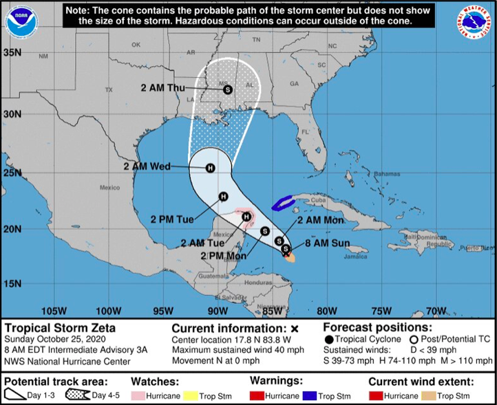
As of now, Zeta remains a tropical storm in the Gulf of Mexico, though it is becoming a powerhouse as it approaches the coastline. The National Hurricane Center predicts that this tropical cyclone will strengthen to a hurricane by the time that it makes landfall on the Louisiana-Mississippi border. By Friday, it will be off the country and could potentially change from a depression to a storm when it makes it back over the Atlantic Ocean.

Moreover, we have good and bad news. We’ll start out with the bad news by letting you know that the rest of the work week will consist of optimal cloud coverage and high chances for showers because of this. However, the good news is that conditions will clear up by the weekend in time for the holiday!
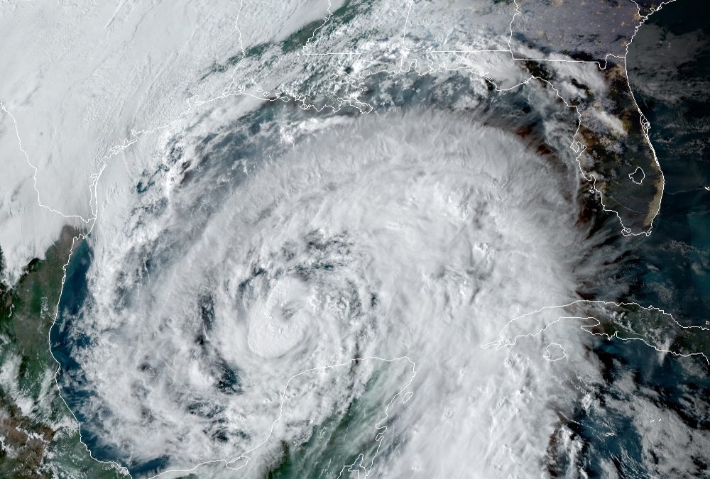
(National Hurricane Center)

That’s all for today, everyone! Have a great rest of your day! See you tomorrow!

Posted in Kentucky Weather | Comments Off on Update on the Tropics

Cloudy, Cooler, and Gloomy Monday

Well we’re definitely not seeing some winter like temperatures for this time of year but get ready for more fall like temperatures to start settling in for the week as some rainfall makes its way through the region. High for today is 61F and the low is 50F, with a slight chance of showers through the late afternoon. About a trace of rain to .5″ is expected to occur for your Monday according to the HRRR 12z model run. Rain chances are expected to stick around for most of the week, so have that umbrella, rain jacket, and windshield wipers ready to go!

Otherwise, Hurricane Epsilon is steering clear of landfall and is expected to stay into the north Atlantic. However, Tropical Storm Zeta is likely to strengthen as it comes up through the Gulf of Mexico. This is expected to impact the southeastern Coastlines of the US, bringing with is some widespread showers as we head into the week. Definitely stay tuned as we fine tune this and keep you guys updated!

Stay safe and Enjoy your Monday!

Courtesy: National Weather Service
Posted in Kentucky Weather | Comments Off on Cloudy, Cooler, and Gloomy Monday

Showers Moving in

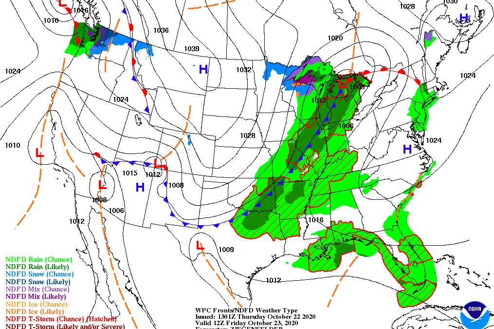
High of 81F with some showers likely for your Friday in South Central Kentucky, so you’ll definitely want to pack that umbrella if you plan on being out and about as a low pressure system dominates the great lakes. A cold front approaching most of the Tennessee Valley will cause total rainfall amounts to be at about .25″ through the region with calm wind conditions out of the Southwest at about 5-10mph. Bringing with it will be much cooler air than what we’ve been seeing on Saturday with a high temperature of 58F and a low of 52F. Other than that, Saturday looks like a dry day overall, so that’ll be the day to get any outdoor chores out of the way. From Sunday and on, we are tracking some additional showers that are headed our way. A big cool down is expected for next week as temperatures stay on the decreasing trend for the most part, so stay tuned with us as we track that out for you!

Stay safe and enjoy your weekend!

Posted in Kentucky Weather | Comments Off on Showers Moving in

The Return of Storms!

Welcome back, everyone! For the first time in a long time, chances for thunderstorms will return to our forecast!

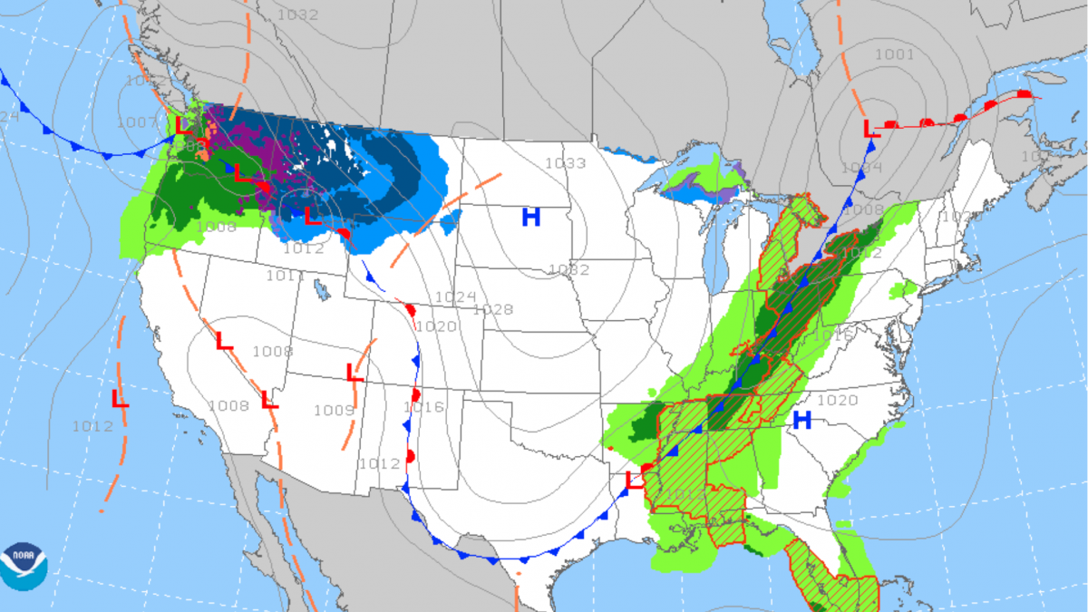
In the morning, showers may form ahead of a cold front as early as 8am. These will be brief and only produce trace amounts of precipitation.

Following that frontal boundary, isolated thunderstorms will begin to form in the afternoon, possibly around 2pm, and remain possible throughout the evening. These will have the potential to produce strong winds and hail.

(Weather Prediction Center)

We advise for you to postpone any outdoor activities for tomorrow evening to avoid the severity of these storms. Stay safe!

Posted in Kentucky Weather | Comments Off on The Return of Storms!

Warmer End of the Week Before Cooling

Good morning everyone!

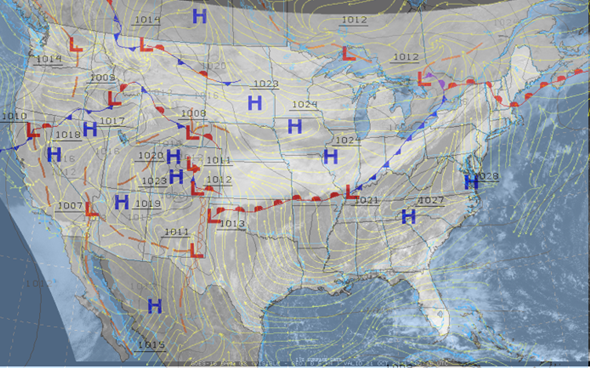
Today will definitely be a big warm-up compared to what we’ve had recently. Those warm temperatures are coming from winds coming in from the Atlantic coast and wrapping around the high pressures in the east.

Source: https://weather.cod.edu/satrad and https://aviationweather.gov/progchart/sfc

Models are in general agreeance with the high temperatures for the next few days but are a little more conflicting with the lows and precipitation amounts for Friday. A high pressure system in southern Canada looks to be squeezed southeast into the US by a deepening low in northeast Canada and a high system in the western US. That high pressure system that is squeezed into the US along with the deepening trough from Canada will push the cold front across us Friday into Saturday. We won’t feel any impacts on the temperature until Saturday, but there is the chance for some light precipitation ahead of the front on Friday. Rain looks to be light but to start in the afternoon hours of Friday and last through until Saturday night.

  • SUMMARY:
    • Wednesday
      • High: 81
      • Low: 60
    • Thursday
      • High: 83
      • Low: 63
    • Friday
      • High: 78
      • Low: 58
      • Precip: .25 inch

Have a fun, safe, and healthy week!

Posted in Kentucky Weather | Comments Off on Warmer End of the Week Before Cooling

Clearing Today to Make for a Summery Wednesday

Hello there! Welcome back to the Western Kentucky University Meteorology Blog! Today started out rather dreary with off-and-on showers that gradually lessened throughout the day. Tonight, these dry, pleasant conditions will carry on into tomorrow, where we will have one last taste of the season that we recently transitioned out of. We will have a noticeable amount of moisture in the air in comparison to what we would normally expect this time of year, and the high temperature could very well surpass 80 degrees. By nightfall, temperatures will decline to the lower 60’s with that muggier air pass sticking around, quite literally!

If you have the time to, get outdoors tomorrow! Don’t forget to hydrate, though. We hope you have a great rest of the day.

Posted in Kentucky Weather | Comments Off on Clearing Today to Make for a Summery Wednesday

Mild & Rainy to Start the Week

Pack that umbrella as you head out the door today as we expect scattered rainfall to be on and off throughout most of the day. We’re above average in temperature for the month so we’re also looking forward to a warmup throughout the rest of the week, but that doesn’t come without some more chances of rain! High for the day will be about 62F and the low will be seasonably mild at about 60F. Relative humidity is at 80% as well, so pretty moist and muggy conditions at the moment. Winds are coming out of the south at 6mph, giving us that warm kick we’ve been feeling as we dive into the fall season. The stationary front will lift northward and bring us another good chance of showers for tomorrow, so definitely stay tuned for more information on that!

Posted in Kentucky Weather | Comments Off on Mild & Rainy to Start the Week

Cooler Temperatures to End Out the Week

Welcome back to the Western Kentucky Meteorology Blog! We hope that you have been able to get outdoors sometime this week to enjoy the weather that we have had!

Today, we have a slight chance for isolated showers throughout the entirety of the day. But, overnight, there will be another cold front passing through, bringing about a lack of precipitation chances and an abundance of cooler temperatures. As a pair of high pressure systems follow suit, we will have pleasant conditions to end out the week. Expect clear skies, calm winds, and cooler temperatures.

(Weather Prediction Center)

Sweater weather, here we come! Have a great weekend!

Posted in Kentucky Weather | Comments Off on Cooler Temperatures to End Out the Week

Big Cooldown for Friday

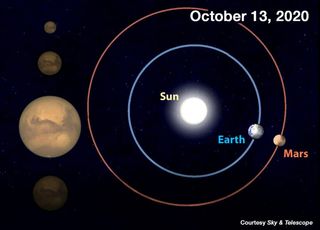
Good morning everyone! Hopefully you all got to see Mars at its brightest last night as it was at peak opposition form the sun.

Mars will reach opposition on Oct. 13, 2020, when the Red Planet will be only 39 million miles (62.7 million km) from Earth — the closest pairing until 2035. As a result, Mars looks much brighter and bigger than usual.
Source: https://www.space.com/mars-opposition-october-2020

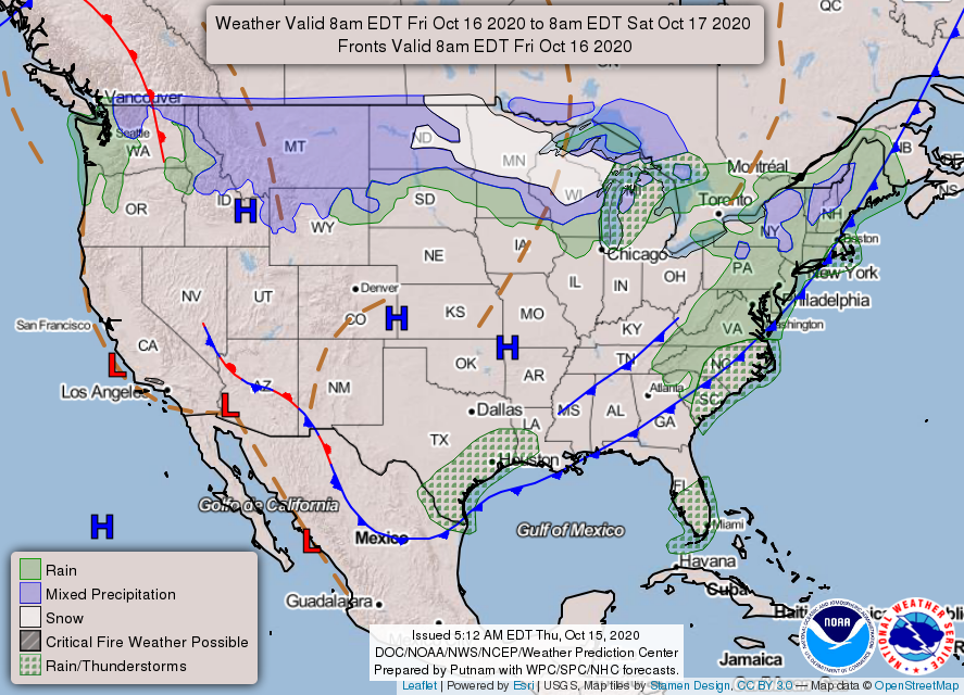
For the time being, we are under a high pressure system so mild conditions will hold until Thursday evening when a cold front will pass bringing some light rain that night as well as cooler temperatures for Friday.

Surface prog chart
Source: https://www.aviationweather.gov/progchart/sfc
  • SUMMARY:
    • Wednesday:
      • High: 79
      • Low: 54
    • Thursday:
      • High: 72
      • Low: 43
      • Precipitation: Trace
    • Friday:
      • High: 59
      • Low: 38

Have a great, safe, and fun week!

Posted in Kentucky Weather | Comments Off on Big Cooldown for Friday

A Beautiful Week Ahead

Good afternoon to you, and welcome back to our blog! We have good news for you, and that is that we are going to be having a relatively quiet week as far as forecasts go! As of now, for most of the week, high pressure systems will be about in our area, making for a fair weather pattern to look forward to. On Thursday, there will be a brief disturbance as a cold front passes through, but conditions look to clear up by Friday and into the weekend.

Moreover, we will see quite the variation in temperatures this week. We have started out fairly warm, but those temperatures will lessen by Thursday, with the frontal passage that is expected. Therefore, Friday and into the weekend, temperatures look to be much cooler than what we started the week out with.

More to come tomorrow! Thank you for reading, and have a wonderful day!

Posted in Kentucky Weather | Comments Off on A Beautiful Week Ahead