Hello, Showers!

The weekend was fairly dry and sunny but get ready to start the week off with some showers for your Monday morning. This is due to a cold front extended right over the Tennessee Valley. The high for today is 71°F and the low is 50°F. Southerly wind flow is priming our atmosphere for the rain chances today. Bowling Green is expected to see the start of light to moderate showers right around noon, with maximum precipitation values of .36 inches. Overall, grab that umbrella as you head out the door and be careful as you commute to and from your lunch plans! Have a good day!

Posted in Kentucky Weather | Comments Off on Hello, Showers!

Warming Things Up

Expect most rainfall from Beta to make its way east and out of the region this morning as we continue the day. The clouds will roll in but no rain is expected for the rest of the weekend. For the next couple of days, things are going to warmup before they cool down. According to the NWS statistics for Bowling Green, we were around 15°F above normal yesterday! The high for today is 77°F and will occur right around 3pm. The low is 63°F with winds remaining light and variable. Temperatures this weekend will creep into the lower 80’s with mostly sunny conditions. Showers will make a return for the start of the work week so definitely stay tuned as we prepare for lower temperatures for the remainder of the work week!

Do you have your pumpkin spice latte ready? Here comes fall!

Posted in Kentucky Weather | Comments Off on Warming Things Up

A Beautiful End to the Week

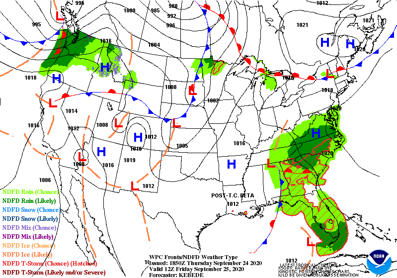
Greetings! Welcome back to the Western Kentucky University Meteorology blog. All of the disruption to the pleasant flow this week can be blamed on post-tropical Beta moving through our region. More specifically, a trough extending out from her core created a boundary of pop-up showers for most of south central Kentucky.

Fortunately, we won’t have to worry about her for much longer. By the looks of it, the chance for showers will only stick around for the rest of tonight and into the early hours of tomorrow. So, if you are on your way to class or work at or before seven o’clock, we recommend you bring a raincoat!

(Weather Prediction Center)

By the afternoon, the clouds will move out and that familiar seasonal trend will return. We won’t see temperatures exceed the upper 70’s nor stoop below the lower 60’s. There will be little to no breeze, but conditions will be comfortable thanks to the lack of humidity.

That’ll do it for today! Get outdoors when you have the chance! Have a great rest of the week!

Posted in Kentucky Weather | Comments Off on A Beautiful End to the Week

Pleasant Start to Fall

Good morning! As you got up and out this morning a few raindrops might have landed on you as post-tropical cyclone Betta made her presence known to us. The rain will continue off and on throughout the day but shouldn’t be anything more than a few sprinkles. With those clouds staying in the sky all day, temperatures will remain fairly low (not pushing past 70°).

Tomorrow we look to have about the same conditions with rain totals looking to be less than 1/10″ so do keep an umbrella handy. By Friday Betta will be finishing moving out of the way. There is a 20% chance of showers up until around 2 pm. Temperatures will be warmer Friday at around 77.

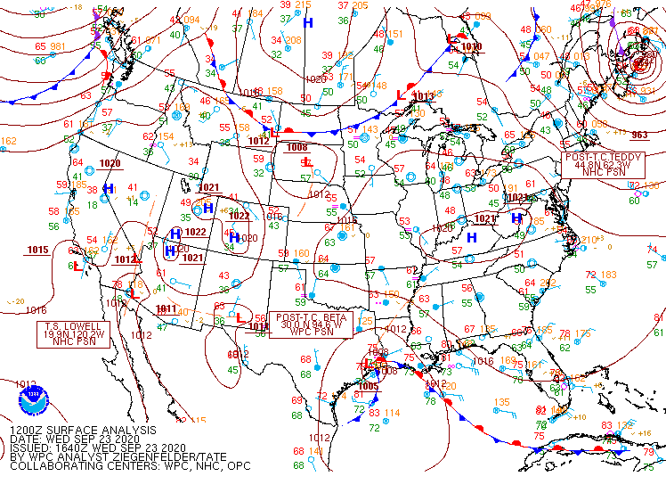
Archived Surface Analysis
Source: WPC

For viewing pleasure check out extra tropical Teddy as it moves towards Nova Scotia.

RAMMB Loop of the Day
  • SUMMARY
    • Wednesday
      • High: 70
      • Low: 58
      • Precipitation: Scattered sprinkles and showers throughout the day. <1/10″
    • Thursday
      • High: 71
      • Low: 59
      • Precipitation: Scattered sprinkles and showers throughout the day. <1/10″
    • Friday
      • High: 77
      • Low: 62
      • Precipitation: 20% chance of showers before 2 pm.

Be safe, be healthy, and have a great week!

Posted in Kentucky Weather | Comments Off on Pleasant Start to Fall

First Day of Autumn

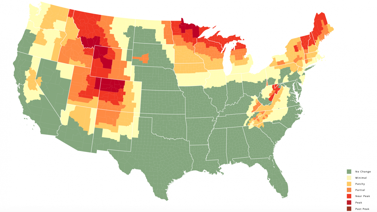
Hooray to the start of a new season! We all know today was the official end of summer and start of autumn, but the colors of the leaves have given us the impression that the unofficial start was sooner. Today, we’ll focus on the predictions for autumn foliage for this year.

Below, the map shows the current state that the country is in as far as the foliage goes. For a better understanding of it, note that green stands for no change in the leaves, orange for a partial change, and maroon for peak change. So far, we have seen no change, but we are expecting to reach peak sometime between October 19th and 26th.

(Smokey Mountains)

For more information, click the map and the page will redirect you to the source. There is a timeline at the bottom of the page that will allow for you to see how the foliage changes with the date that you choose.

That’s all for today! Make it a great one or not, that choice is yours!

Posted in Kentucky Weather | Comments Off on First Day of Autumn

Pleasant Fall Weather Continues

Pleasant fall weather will continue as our region takes part in a surface high pressure system extending from the New England States. The high for today is 77°F and the low is 50°F with mostly sunny conditions throughout the day. The low level thickness models shows support for temperatures being lower than average in both the daytime and nighttime, so pack a light sweater as you head out after dusk.

The story changes later this week as a cold front approaches the Tennessee Valley. The next chance of rain comes Thursday with isolated showers, but we’ll keep you updated on that.

Posted in Kentucky Weather | Comments Off on Pleasant Fall Weather Continues

Our Last Taste of Summer

Prepare to enjoy one of the last weekends that summer has to offer as temperatures start to cool off as we head into the fall season. A cold front is pushing eastward from the Tennessee Valley this morning with the last of the rainfall moving through eastern North Carolina. Fair weather will set us up for a fairly dry weekend, as a surface high pressure rests over the great lakes, bringing with it some below average dew points for the summer season. The high for today is 73°F with mostly sunny conditions for most of the day. The low for today is 48°F.

Game day’s high will be 71°F and the low will be 47°F with still mostly dry and sunny conditions.

Sunday’s high will be 74F° and the low will be 50°F. This is going to be the main setup to kick of the beginning of the work week as well.

Stay safe and make sure you take advantage at some of our last tastes of summer!

Posted in Kentucky Weather | Comments Off on Our Last Taste of Summer

New Seasonal Trend Begins

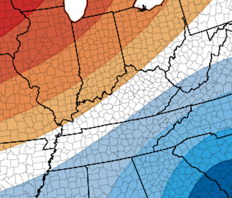
Welcome back to our blog! We all know that the next season does not begin until next week, but the trend in temperatures that we will be seeing will make you think otherwise!

Those crisp mornings and nights will be a part of this trend, as temperatures will stoop down to the upper 40’s starting tomorrow! Whereas, in the afternoons, temperatures will only reach the lower 70’s. We will see this pattern play out through the end of the week!

(Climate Prediction Center)

In the graphic above, warmer colors indicate above normal temperatures, cooler colors indicate below normal temperatures, and white indicates regular temperatures. So, this trend will be nothing new for this time of year, but it serves to be a transition into the new season!

That’s all for today. Get outdoors and enjoy this weather this weekend!

Posted in Kentucky Weather | Comments Off on New Seasonal Trend Begins

Fall Like Conditions on the Way!

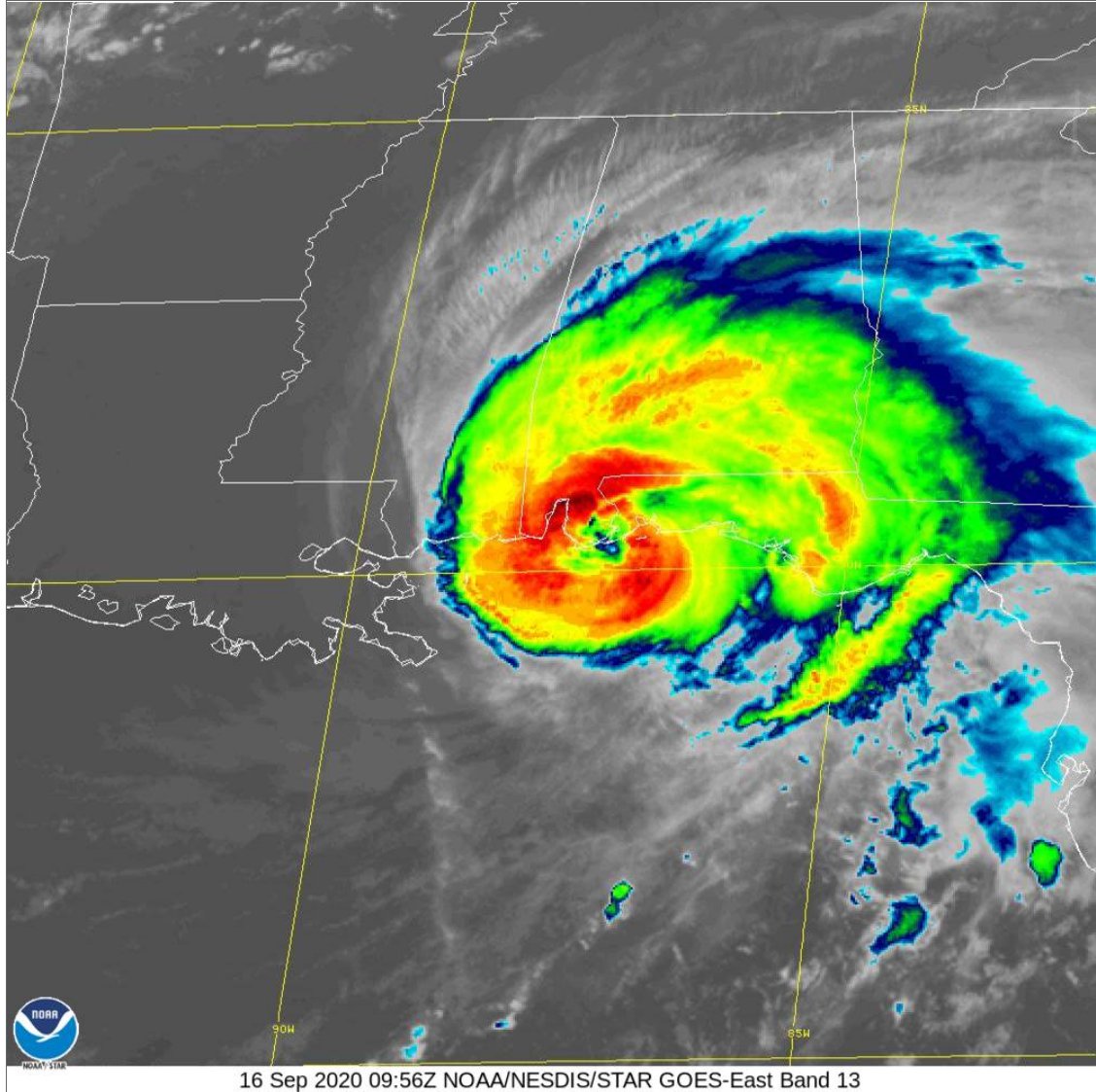
Hurricane Sally officially made landfall early this morning at 4:45 as a category 2. It has continued to produce massive flash flooding across many areas in the south, especially along the Gulf. This system has been fairly slow moving allowing it to take in more moisture and produce more rain.

Image
Source: @NHC_Atlantic

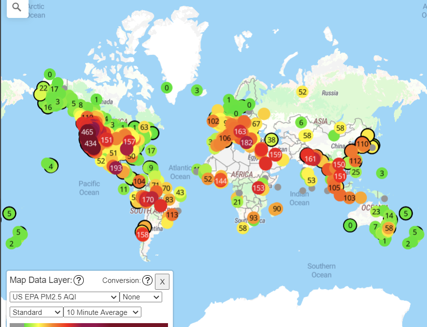
Something else that’s been on everyone’s minds is the wildfire out west. Many of those continue to burn and have unfortunately created very dangerous air quality with values over 400.

Source: Purpleair.com

As those fires continue burning, the smoke from them continues to cover the sky for much of the country. The majority of that smoke appears to have shifted northerly.

As far as local weather goes, conditions will be nice for today and through the weekend. Today and Thursday will be a little on the warmer side in the lower 80s, but as Sally shifts by and with a cold front passing southeast Friday morning temperatures will lower into the 70s.

  • Summary
    • Wednesday
      • High: 85
      • Low: 65
    • Thursday
      • High: 83
      • Low: 58
    • Friday
      • High: 72
      • Low: 51

Stay safe, stay healthy, and have a great week!

Posted in Kentucky Weather | Comments Off on Fall Like Conditions on the Way!

Update on the Tropics

Welcome back to Western Kentucky University’s Meteorology Blog! Thank you for checking out today’s post. Because our forecast will remain rather uneventful for the rest of the week, let’s take a look at the tropics!

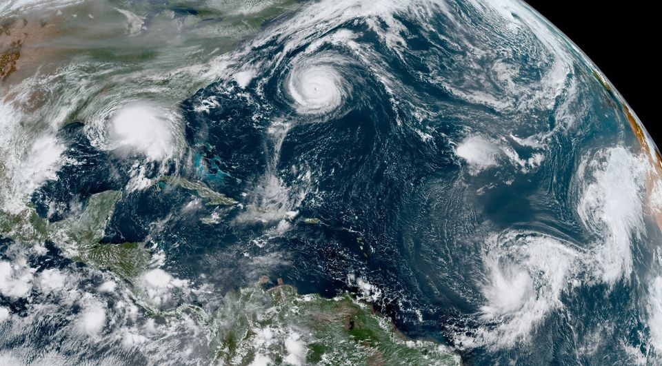
As of now, there is a cluster of five tropical cyclones over the Atlantic basin. According to The National Hurricane Center, this “ties the record for the most number of tropical cyclones in that basin at one time, last set in Sept 1971”. Below is a photo shared by the organization to show the activity.

National Hurricane Center

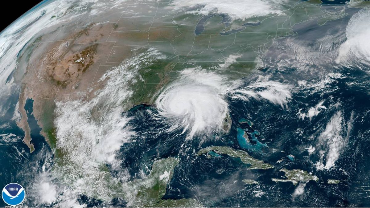
Tomorrow, it is predicted that Sally (pictured below) will make landfall as a category 1 hurricane. Because of this, shower and storm chances will return to the forecast for tomorrow and Thursday. However, the severity will lack, and the main threat that will accompany these storms will be a fair amount of rainfall.

National Hurricane Center

That’s all for today! Make it a great one or not, that choice is yours! Signing off.

Posted in Kentucky Weather | Comments Off on Update on the Tropics