Groundhog says spring in 2 more weeks!

First to recap this historic storm which produced tremendous amounts of ice and snow to our northwest along with very gusty winds for most of the country.

for regional recaps follow these links.

http://www.crh.noaa.gov/lsx/?n=02_01_2011

http://www.srh.noaa.gov/news/display_cmsstory.php?wfo=tsa&storyid=63371&source=0

http://www.crh.noaa.gov/sgf/?n=event_2011feb01_summary

http://www.crh.noaa.gov/news/display_cmsstory.php?wfo=ind&storyid=63391&source=0

http://forecast.weather.gov/product.php?site=NWS&format=CI&version=1&glossary=0&highlight=off&issuedby=BOX&product=LSR

and for wind gusts in our region

http://www.crh.noaa.gov/news/display_cmsstory.php?wfo=lmk&storyid=63501&source=0

what a storm wish the blizzard would have hit here personally but no ice which is good!

Looking in the long range I see several signs that the unexpected cold and frequent snow of the winter will turn into more of a typical la-nina pattern around here meaning warm for the mid-south with cold over the northwest and more frequent rains  but that is still 2 weeks away.

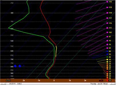
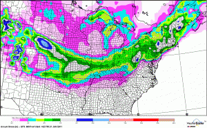
Earlier this week I suggested while quite a few of the models were dry for Friday night and Saturday that would see periods of snow as a low tracking up the east coast would correct west with time on the models. This appears the case as an upper low will track from Texas into eastern Kentucky with one region of snow northwest of the track while the main surface low is along the east coast. Overall I expect .1-.3 qpf to fall a nice blend of the wet NAM the drier GFS and the SREF from Friday into Saturday. Light snow should develop late Friday afternoon with steady snow Friday night into Saturday. It may start out as rain for a hour or two Friday but quickly change to snow withaccumulations from 1-3 inches any track and strength change with the upper low could result in adjusting of snow totals.
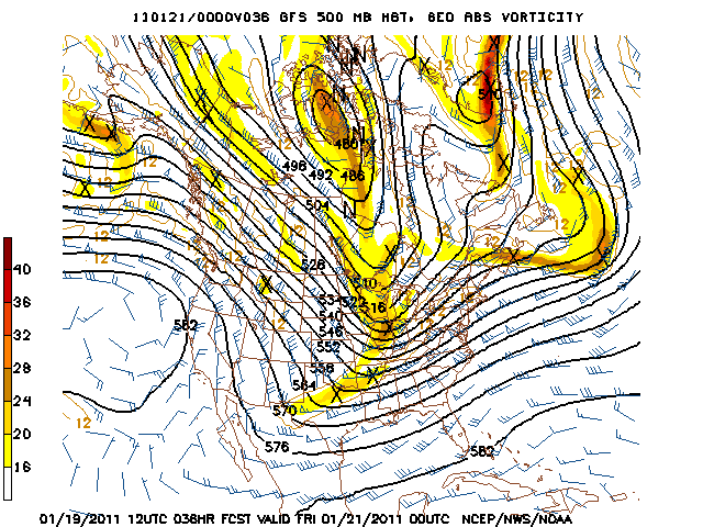
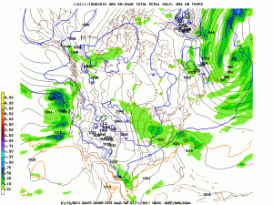
NAM 500 mb map

– friday afternoon the energy is over Texas

By Saturday morning it moves into our region developing the period of snow for late Friday into Saturday.

temperatures will be in the mid to upper 10’s Thursday morning with Highs Thursday in the mid 30’s with fair skies. Lows Friday should be in the mid 20’s with increasing clouds during the day and highs from the mid to upper 30’s. Lows will be around 30 which could lead to some slick spots given the accumulation of snow expected, winter weather advisories may be issued for the region as a result.

This weekend we should warm-up some. This leads into next week one piece of energy should work through Sunday and Monday with a light rain to light snow deal with arctic air coming in behind. At the same time another piece of  energy is left behind in the southern Rockies and as a southeast ridge tries to build it could lead to a classic snowstorm track for the mid south from Texas through the southeast and up the east coast for Late Tuesday through Wednesday of next week if enough energy is left behind in the southern Rockies. Also cold air in the 10’s and 20’s would be pouring in to increase snow ratios more than a typical gulf storm or arctic wave. This should be watched closely as several of the GFS bufkit runs that were trying to form a storm in this timeframe had anywhere from 4 to 9 inches of snowfall at Bowling Green. Another possibility is for the first piece of energy to be stronger and cut into the lakes bringing rain showers to flurries then for the second piece to be very week and actually bring snow  to the gulf coast and track well to our south. right now modeling is split on this DGEX,NOGAPS,JMA and CMC all favor the bigger snowstorm while the UKMET and GFS favor the first piece of energy being stronger with the ECMWF trying to make two storms next week. For now my thinking is that the atmosphere should be to worked over for a storm Sunday into Monday just after two storms in the last week thus the majority of the energy should bundle in the southern Rockies and take that favored snowstorm track by the middle of next week that could be the first 6 snow in recent Bowling green history. But again could be wishful thinking in the long run. speaking of wishful thinking in the other direction A tanking (-) PNA an AO going positive and the long range charts of the ECMWF and GFS show a pattern flip to a typical la-nina pattern which is much warmer than this winter so far around the 15th.

I’ll update again on Friday. My forecast now is 1-3 inches of snow Friday night.

MWG

Posted in Kentucky Weather | Comments Off on Groundhog says spring in 2 more weeks!

forecast through mid week

An arctic cold front will be in place over the upper Ohio valley into the Ozarks. We will be in the warm sector as a result mild air will continue to stream into the region with highs in the low 50’s with the threat for a stray shower. Also low pressure will develop along the front leading to the entire forecast period being mostly cloudy. By Tuesday afternoon the low pressure will deepen and track overhead leading to increasing southerly winds along with heavy rain and thunder by Tuesday night the lack of instability should prevent any strong to severe storms. Highs Tuesday may actually reach the low 60’s after morning lows in the 40’s. The low pressure and frontal boundary will move through early Wednesday leading to much colder conditions with temperatures steady in the mid 30’s with a chance for flurries. The next chance for any measurable snow will be late Friday and Saturday

– there is good agreement on the modeling for the first system Tuesday with high confidence. However I feel looking at the 500 mb pattern the next system for fri-sat should trend northwest with time on the modeling  giving us a chance for snow.  during

Posted in Kentucky Weather | Comments Off on forecast through mid week

spring preview in progress!

we see many temperature busts with modeling and forecasts underdoing the WAA ahead of a week clipper which will pass well to our north. This will result in melting of the persistent snowcover across the region. Highs today will be in the 50′s with BWG near 60. Tonight I still expect lows to fall into the 30′s. I’m going with the warmer ECMWF Sunday for highs in the low to mid 50′s Sunday for the south and 40′s north keeping clouds away Till Sunday night .

An arctic boundary moves into the upper Ohio valley with rain developing along it for Monday through Tuesday night. In fact I like the ECMWF continuing to take this low over Paducah keeping any freezing rain threat minimal and bringing a severe threat from AL into TN and perhaps southern and southeast KY. The 12z ECMWF surface output can’t be shown due to copyright laws. Any severe threat for the south would be shear not instability driven with gusty winds the main threat. Other wise I expect the region to see a soaking rain of 1 to perhaps 2 inches from monday night through early Wednesday. I expect highs in the 40′s Monday with Monday night around 32 north which could lead to a brief period of frz rain for CVG and highs again well into the 40′s and 50′s Tuesday.  By Wednesday the cold front swings through behind the storm and we end up with flurries and temps in the 30′s as southerly winds shift to northwesterly.

This boundary stalls late week over the south and in my view is ideal for the secondary low theory with the ecmwf,cmc and jma all showing this my confidence is higher than usual with secondary lows. My thinking is this should be snowmaker here if there is one this upcoming week. timing would most likely be Saturday.

notice how we’re warm for most of this week and have been cold all winter?  the cold has mainly due to the AO through mid JAN and the PNA till now. notice the PNA going strong negative which is not a cold signal . The AO is positive this week but may go negative around the 7th again. But for this week for the first time all winter no teleconnections are governing cold and the la-nina can have some influence.

AO

PNA

GFS rainfall Mon-Tue, ECMWF is lighter

The the groudhog will be waiting for two things to determine if he sees his shadow this week

1. if the AO projections next week for mid month go positive

2. The ECMWF weeklies ( since I haven’t seen them yet)

Posted in Kentucky Weather | Comments Off on spring preview in progress!

storm recap, winter viewpoints and thoughts on the next few days

Overall around 2 inches of snow fell in Warren county with higher amounts just to our southwest and east of around 4 where the heavier bands set-up. I have seen no totals which confirm the 3-5 the NWS has  for Warren county.  This was the hardest forecast of the season in my view with the exception of the Christmas eve snow. Both of these events relied on mesocale banding to produce the snowfall accumulations which is what the modeling used in meteorology can’t pinpoint. Also the changeover time was a challenge but occurred at the right time for the expected accumulations. The warm and wet ground may have held accumulations down a touch as well. Tonight there may still be some black ice from the moisture left over with lows in the 20’s overnight.

1. I think Thursday features some sunshine with increasing clouds late as a clipper system passes to the north. An interesting battle tomorrow between WAA ahead of a clipper and a snowcover for temperatures. For now I think highs reach the mid 30’s during the day then temperatures are steady Thursday night. By Friday morning with a clipper passing well to the north a few sprinkles or flurries could fall early. This clipper will track north of us like a typical clipper and bring the light accumulation of snows to Ohio and northeast KY.

2. The weekend should be seasonable and dry. Thought some modeling brings some rain close on Sunday I don’t see that occurring.  

3. Another system forms in the southern plains with a clash between cold arctic air moving in and some southerly flow ahead of the low.  In fact the ECMWF is showing signs the typical la-nina SE ridge appears and sends a storm into the great lakes bringing a nice warm-up and rain. The GFS is zonal with an arctic air intrusion by Monday with any storm suppressed along the gulf coast. Neither solution will likely be correct the GFS tends to overdo arctic air intrusions and keep storm tracks to far south while the ECMWF is known for holding back energy to much over the west with over amplifies the trough/ ridge pattern. For now thinking a low tracks from Texas into the region then transfers energy to the east coast This track usually means a sloppy mix for the mid-south.

– Overall this winter BWG has recorded just over 15 inches of snow. this is already 150% of normal for the season. My winter forecast for Bowling Green featured about 50% of normal of snow. The main reason for the bust  is the unexpected teleconnectionpattern of a negative AO for over a month of the winter and a positive PNA is recent weeks. Both of these promoted a eastern trough, cold and snowy instead of the typical la-nina storm track warm and west of us. As for snowfall the remainder of the winter we have a shot early next week some arctic air follows then maybe another chance around the 10th before a warm-up begins to a more typical la-nina pattern. We have a shot at 200% of normal snowfall but it’s been an easy ride to 150% expect the last 50% to be rougher.

MWG

Posted in Kentucky Weather | Comments Off on storm recap, winter viewpoints and thoughts on the next few days

overnight update

Rain has changed to snow with temperatures falling below freezing. The
heaviest precipitation currently is in a horseshoe from east of
Nashville into Warren county then southwest to clarksville with a
dry slot south of Nashville. This period of heaviest precipitation can
produce snowfall rates of 1/2 inch per hour overnight for several
hours. Snowfall will become lighter toward dawn and last through the
morning commute. totals of 3-5 inches with locally higher amounts are
possible overnight and Wednesday morning. The totals were raised based
on the current radar display showing heavy precipitation and our STN
WRF model which still produces plenty of precipitation for snowfall
overnight in this range. Temperatures will fall below freezing
leading to the development of slick spots. Roadways will become slick,
hazardous and perhaps snow covered for the commute to work or any
school buses.

Lead forecaster:MWG

Posted in Kentucky Weather | Comments Off on overnight update

staying the course for now

We’ve seen the NWS go from a dusting after the issuance of this forecast to a winter storm watch for 4-6 inches back to the 2-4 forecasted here yesterday. That shows the uncertainty level with this storm. Tonight is a mesoscale analysis on what will happen.

radar

http://radar.weather.gov/Conus/southmissvly_loop.php

make sure to go the mesonet page for temps!

Rain is currently falling across the region with temperatures near 40. the freezing line is charging east into christian county at this time. This line will slowly move east overnight reaching our region after midnight. However conditions aloft with heavy precipitation support a changeover to snow perhaps mixing with sleet around midnight. Some of the modeling this afternoon is suggesting that snow lasts till noon on Wednesday now with several hours of steady snow in the subfreezing air overnight through Wednesday morning which will result in slicker roads than previously thought. Snow may be heavy at times with the potential for banding with the snowfall that are slow moving all of these factors may require us to raise snow amounts overnight and the NWS to issue a winter storm warning for our region. Currently we will wait till the changeover occurs before deciding on any changes to totals. Right now thinking of 2-4 inches after midnight till noon on Wednesday with difficult travel conditions for the morning commute to work or school with snow ongoing. This system has been the most difficult to forecast this winter season in terms of any change to a small detail can result in little or excessive snowfall. Another update will be released once the changeover is starting to occur in our region. A winter weather advisory remains in effect.

lead forecaster:MWG

Posted in Kentucky Weather | 2 Comments

First forecast on accumulations for Tuesday-Wednesday

A low pressure system is expected to develop along the gulf coast states and ride northeast into the southeastern United States. After highs in the 40’s today with drizzle and fog lows tonight will be in the 30’s followed by highs near 40 Tuesday with more clouds and drizzle. However by Tuesday night Low pressure comes northward developing a shield of precipitation on the backside. We will be northwest of the low track. in recent days there has been some speculation we may be to far west However as usual the track of storms like this one has shifted west over time as the modeling gets a better handle on storm strength.

The NAM model had convective feedback issues due to over development of thunderstorms in the gulf.  The GFS is coming west but is likley not quite west enough yet. My thinking lies with the ECMWF 12z run and the GFS ensemble mean which means around .5 of qpf into the region from Tuesday night to noon on Wednesday. With highs near 40 Tuesday temperatures may only cool into the mid 30’s by midnight. However thickness values and temperatures aloft are more supportive of snow once the precipitation starts. I expect a light rain to break out Tuesday evening this will change to snow around midnight through a process called dynamical cooling. My thinking is heavy precipitation rates will offset marginal thermal profiles for snow. Snow will be heavy at times early Wednesday morning with an expected accumulation of 2-4 inches of wet snow for Bowling Green. With temperatures near freezing roads may stay wet but heavy snowfall rates may make for slick travels. Snow should end by noon Wednesday with highs in the mid 30’s.

This snowfall forecast is largely dependent on several factors

– how much dynamical cooling occurs and how quickly

– track of the low I’m thinking owensboro 60 miles NW of us gets nothing and lake Cumberland 60 mi SE of us gets 6 or more inches. Any change in the track could lead to altered amounts. It should be noted any shifts are likely to be to the west.

– convective bands that may set-up thunderstorms could curl around the low center my thinking now is the best chance for any convective thundersnow is over lake Cumberland or further southeast. 

– downsloping flow off the apps which would limit qpf

Overall this forecast for 2-4 inches of wet snow early Wednesday has low to medium confidence.

MWG

Posted in Kentucky Weather | 1 Comment

Cold temperatures return, but with a break in weather…

Well we will see a little break in the wintry weather this weekend, however as this past snow storm swung through it brought down some bitterly cold air behind the system. Today will be by far the coldest with a high in the low 20s and a low tonight in the lower teens. So look for a possible re-freeze of the roadways in some areas. The sun today will help melt a lot of the snow pack and clear the roadways. Here is a map of the reported snow totals for our region…snowfall-totals

The sun will be out the rest of the weekend, with highs Saturday and Sunday rising just above the freezing mark and lows will dip back into the teens at night. We will stay under mostly cloudy skies with some sunshine as a high pressure has built in over the area. Another weak clipper system may bring some flurries Saturday night but will not amount to anything at all. The next system that could bring some very light snow to the area would be at the start of next week, but does not look like a storm to impact travels at the beginning of the work week but stay tuned as we will have more information later.

Friday: Hi 23 Lo 14. Partly sunny with winds out of the north at 6 mph.

Saturday: Hi 32 Lo 22. Mostly cloudy skies, winds SSW 5-10 mph. 20% of flurries at night.

Sunday: Hi 35 Lo 26. Mostly cloudy skies, with winds out of the south around 5 mph. 20% of snow late.

Posted in Kentucky Weather | Comments Off on Cold temperatures return, but with a break in weather…

Winter Storm On Its Way…

Winter storm to affect our region Thursday through Thursday night.

An upper level trough is digging in the west in association with a surface low forming off the leeward side of the Rockies in the Texas Panhandle. As the low progresses eastward precipitation will makes its way into the area west to east on Thursday. The trough will reach the region Thursday afternoon which is when our best shot of moderate snow would be.gfs_500_036s

Snow looks to start in south central Kentucky between 1 and 4 pm tomorrow afternoon and will exit the region Friday morning, with some lingering flurries possible through mid morning Friday. BUFKIT sounding for Bowling Green shows good dentritic growth in the -10 to -20 degree Celsius range indicating abundant moisture and respectable vertical motion. I have the highlighted dentritic growth zone in yellow in the sounding below.bufkit-sounding

As far as accumulations go, south central Kentucky should see generally 1-3 inches with locally higher amounts possible. It does seem we have good moisture in place to support this. Also with temperatures being in the upper teens Thursday night expect roadways to deteriorate as the heavier snow starts to fall and we approach nighttime hours.earl-barker-gfs1

An update will be coming tomorrow ahead of the storm system to let you know of any changes. I encourage you readers to report road conditions and snow totals so we can update the blog to inform people thinking of getting out on the roads. And reporting snow totals we can give a summary of the event and compare our forecast with what really happened. Thanks for reading and enjoy the rest of your day.

Wednesday: Cloudy, Hi 38 Lo 28. Winds out of the Northwest 3-7 mph.

Thursday: Snow, Hi 37 Lo 17. Snow accumulations 1-3 inches by Friday morning. Winds out of the northwest at 7-10 mph.

Friday: Partly sunny and cold, Hi 22 Lo 13. Northwest winds 10-15 mph.

Posted in Kentucky Weather | Comments Off on Winter Storm On Its Way…

Light Snow Tonight…more snow chances and chilly weather this week…

After evaluating the more reliable 0z (0z and 12z runs use observed upper air data from the U.S. radiosonde network) suite of model runs, there remains favorable continuity with the last set of model runs with only a sharpening of the QPF gradient. Snowfall totals for Monday seem to be consistently forecasted as 2 inches along the KY/TN border where counties 1 tier north of those getting an inch or less of the white stuff. The snow really drops off north of Nashville with totals there being 3 to 4 inches if you happen to be traveling.

Forecast soundings from the RUC, observed in bufkit, have about a half of an inch of snow in Bowling Green, while areas to the south and east receiving just a touch more. Feel that this is good due to continuity of forecast products with the SREF and the fact that any snow that initially falls will fall as virga (precipitation that evaporates before it reaches the ground). This forecasted sounding from the RUC shows precipitation beginning to accumulate in Bowling Green @ 5a.m.

bufkitprofileruc

All of that aside, With freezing ground temperature in place any snow will readily stick and untreated roads will become snow-covered. So take it slow tomorrow morning as the onset of precipitation looks to begin at about 2 a.m. Monday morning at the KY/TN border as seen below in the RUC rapid high resolution rapid refresh (HRRR) simulated radar reflectivity.

hrrrsimradar

For any Kentuckians left without snow from this first shot, most of us will luck out with a second chance on late Monday night into Tuesday. Even though this first surface system is more potent and will drop more snow in the south, its lagging upper level energy will swing through the
Midwest Monday evening, and cause the formation of a surface low in TN that will quickly move northeastward.

There is some disagreement on the exact track, but regardless there will be widespread light snows across most of Kentucky. For now it appears that the further north with this second system, the more snow you will receive. 1-2 inches will not be out of the question for central Kentucky, while northward crossing the Ohio river into Indiana, those areas could receive up to 4 inches. There is still some deviation in model solutions with this second impulse of energy, so no need to carve it in stone yet.

As of now onset of precipitation with the second system will likely start around midnight Monday night and the accumulating snow showers will have moved out by Tuesday afternoon. Snow flurries will continue off and on through Wed. due to wrap around moisture and a cold northwest flow behind the system.

In summary for Bowling Green:
Tonight: Snow flurries after midnight light snow in the early morning
hours, low 24

Monday: High 32, light snow before noon total accumulation <1″,
chance of snow flurries the rest of the day

Monday night: Low 28 snow develops after midnight .5″

Tues: High 32, light snow, new snow .5″

Wed: Mostly Clear, Cold HI=25 low=13

Fri: Mostly Clear, HI=31 low =21

Posted in Kentucky Weather | Comments Off on Light Snow Tonight…more snow chances and chilly weather this week…